San Carlos de Bariloche elevation
San Carlos de Bariloche (Rio Negro, Departamento de Bariloche), Argentina elevation is 839 meters and San Carlos de Bariloche elevation in feet is 2753 ft above sea level [src 1]. San Carlos de Bariloche is a seat of a third-order administrative division (feature code) with elevation that is 489 meters (1604 ft) bigger than average city elevation in Argentina.
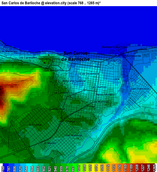
Below is the Elevation map of San Carlos de Bariloche, which displays elevation range with different colors. Scale of the first map is from 768 to 1265 m (2520 to 4150 ft) with average elevation of 873.1 meters (=2865 ft) [note 1]
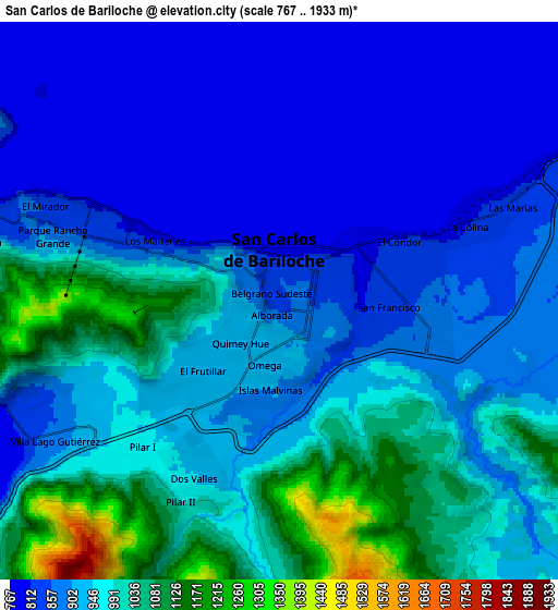
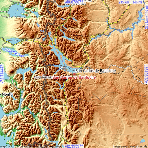
These maps also provides idea of topography and contour of this city, they are displayed at different zoom levels. More info about maps, scale and edge coordinates you can find below images.
| \ | Map #1 | Map #2 | Topo.Map |
| Scale [m] | 768..1265 m | 767..1933 m | × |
| Scale [ft] | 2520..4150 ft | 2516..6342 ft | × |
| Average | 873.1 m = 2865 ft | 923.6 m = 3030 ft | × |
| Width | 7.36 km = 4.6 mi | 14.72 km = 9.1 mi | 235.5 km = 146.3 mi |
| Height | 7.36 km = 4.6 mi | 14.72 km = 9.1 mi | 235.5 km = 146.3 mi |
| ↑Max Latitude | -41.112469° | -41.079351° | -40.07807° |
| Latitude at center | -41.14557° | -41.14557° | -41.14557° |
| ↓Min Latitude | -41.178654° | -41.211722° | -42.19597° |
| ← Min Longitude | -71.352165° | -71.396111° | -72.71447° |
| Longitude center | -71.30822° | -71.30822° | -71.30822° |
| →Max Longitude | -71.264275° | -71.220329° | -69.90197° |
Nearby cities:
Cities around San Carlos de Bariloche sort by population:
• San Martín de los Andes elevation 651 m
109.9 km,  358°
358°
• El Bolsón 320 m
92.5 km,  191°
191°
• Junín de los Andes 779 m
134.4 km,  8°
8°
• Villa La Angostura 796 m
51.3 km,  326°
326°
• Ingeniero Jacobacci 872 m
148.4 km,  97°
97°
• Lago Puelo 207 m
105.3 km, 193°
• El Maitén 704 m
101.2 km,  173°
173°
• Hoyo de Epuyén 231 m
104.3 km, 189°
• Pilcaniyeu 987 m
49.2 km,  87°
87°
• Comallo 772 m
88.1 km,  81°
81°
• Leleque 664 m
142.2 km, 171°
• Ñorquinco 876 m
85.4 km,  156°
156°
Multilingual:
 En español:
San Carlos de Bariloche elevación 839 m.
 En France:
Bariloche élévation 839 m.
 Auf Deutsch:
Bariloche höhe über dem Meeresspiegel ist 839 m.
 На русском:
Сан Карлос де Барилоче высота над уровнем моря 839 м
Sources and notes:
- [note 1] Map square and city borders are not equal. Map elevation data is calculated only from area inside that square.
- [src 1] Elevation data from geonames database provided with same terms of usage.
- [src 2] The elevation map of San Carlos de Bariloche is generated using elevation data from NASA's 3 arcsec (90m) resolution SRTM data.
- [src 3] Base (background) map © OpenStreetMap contributors tiles are generated by Geofabrik and OpenTopoMap.
Copyright & License:
This San Carlos de Bariloche Elevation Map is licensed under CC BY-SA. You may reuse any part from this page, if you give a proper credit by linking to this URL:
 More info on terms of use page.