Catriló elevation
Catriló (La Pampa, Departamento de Catriló), Argentina elevation is 129 meters and Catriló elevation in feet is 423 ft above sea level [src 1]. Catriló is a seat of a second-order administrative division (feature code) with elevation that is 221 meters (725 ft) smaller than average city elevation in Argentina.
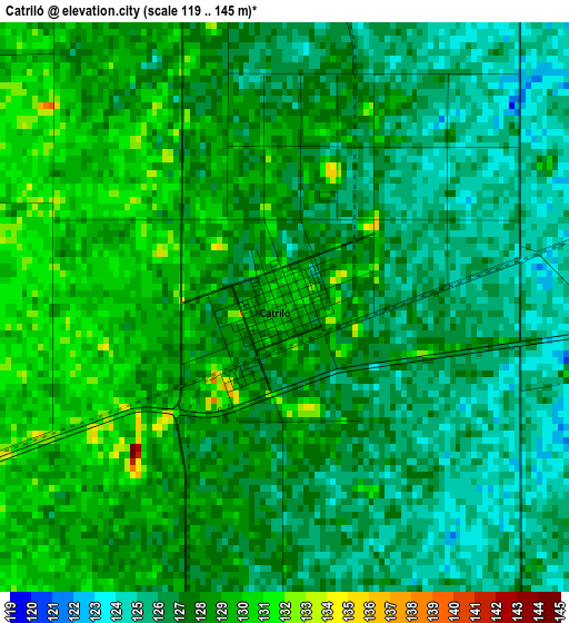
Below is the Elevation map of Catriló, which displays elevation range with different colors. Scale of the first map is from 119 to 145 m (390 to 476 ft) with average elevation of 127.1 meters (=417 ft) [note 1]
These maps also provides idea of topography and contour of this city, they are displayed at different zoom levels. More info about maps, scale and edge coordinates you can find below images.
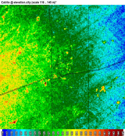
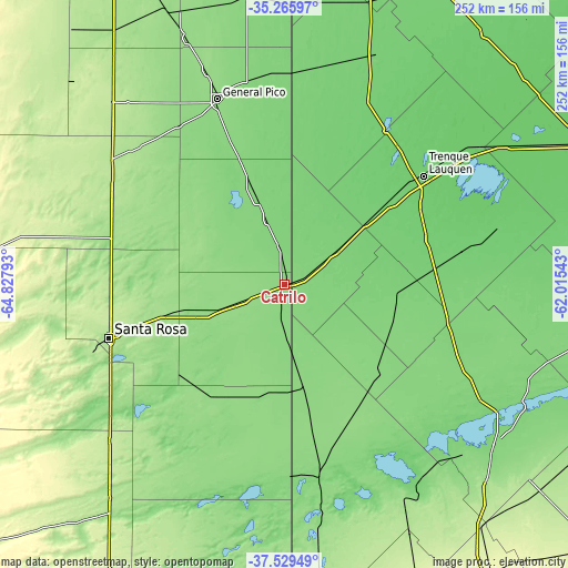
| \ | Map #1 | Map #2 | Topo.Map |
| Scale [m] | 119..145 m | 116..145 m | × |
| Scale [ft] | 390..476 ft | 381..476 ft | × |
| Average | 127.1 m = 417 ft | 126.2 m = 414 ft | × |
| Width | 7.87 km = 4.9 mi | 15.73 km = 9.8 mi | 251.7 km = 156.4 mi |
| Height | 7.87 km = 4.9 mi | 15.73 km = 9.8 mi | 251.7 km = 156.4 mi |
| ↑Max Latitude | -36.370593° | -36.335201° | -35.26597° |
| Latitude at center | -36.40597° | -36.40597° | -36.40597° |
| ↓Min Latitude | -36.441331° | -36.476675° | -37.52949° |
| ← Min Longitude | -63.465625° | -63.509571° | -64.82793° |
| Longitude center | -63.42168° | -63.42168° | -63.42168° |
| →Max Longitude | -63.377735° | -63.333789° | -62.01543° |
Nearby cities:
Cities around Catriló sort by population:
• Santa Rosa elevation 179 m
80.5 km,  253°
253°
• Quemú Quemú 121 m
41.1 km,  341°
341°
• Colonia Barón 154 m
48 km,  306°
306°
• Winifreda 169 m
75.5 km,  285°
285°
• Miguel Riglos 144 m
55.2 km,  205°
205°
• Anguil 159 m
54.3 km,  255°
255°
• Lonquimay 142 m
19.3 km, 249°
• Uriburu 144 m
41 km, 254°
• Trenque Lauquen 95 m
78.4 km,  51°
51°
• Salliqueló 129 m
56.4 km,  133°
133°
• Tres Lomas 116 m
50.5 km,  96°
96°
• Pellegrini 115 m
27.7 km,  55°
55°
Multilingual:
 En español:
Catriló elevación 129 m.
 En France:
Catriló élévation 129 m.


Sources and notes:
- [note 1] Map square and city borders are not equal. Map elevation data is calculated only from area inside that square.
- [src 1] Elevation data from geonames database provided with same terms of usage.
- [src 2] The elevation map of Catriló is generated using elevation data from NASA's 3 arcsec (90m) resolution SRTM data.
- [src 3] Base (background) map © OpenStreetMap contributors tiles are generated by Geofabrik and OpenTopoMap.
Copyright & License:
This Catriló Elevation Map is licensed under CC BY-SA. You may reuse any part from this page, if you give a proper credit by linking to this URL:
 More info on terms of use page.