Daireaux elevation
Daireaux (Buenos Aires, Partido de Daireaux), Argentina elevation is 118 meters and Daireaux elevation in feet is 387 ft above sea level [src 1]. Daireaux is a seat of a second-order administrative division (feature code) with elevation that is 232 meters (761 ft) smaller than average city elevation in Argentina.
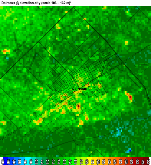
Below is the Elevation map of Daireaux, which displays elevation range with different colors. Scale of the first map is from 103 to 132 m (338 to 433 ft) with average elevation of 114.5 meters (=376 ft) [note 1]
These maps also provides idea of topography and contour of this city, they are displayed at different zoom levels. More info about maps, scale and edge coordinates you can find below images.
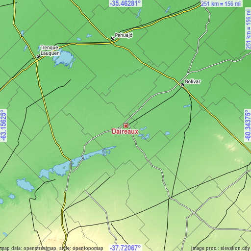
| \ | Map #1 | Topo.Map |
| Scale [m] | 103..132 m | × |
| Scale [ft] | 338..433 ft | × |
| Average | 114.5 m = 376 ft | × |
| Width | 7.85 km = 4.9 mi | 251.1 km = 156 mi |
| Height | 7.85 km = 4.9 mi | 251 km = 156 mi |
| ↑Max Latitude | -36.564712° | -35.46281° |
| Latitude at center | -36.6° | -36.6° |
| ↓Min Latitude | -36.635272° | -37.72067° |
| ← Min Longitude | -61.793945° | -63.15625° |
| Longitude center | -61.75° | -61.75° |
| →Max Longitude | -61.706055° | -60.34375° |
Nearby cities:
Cities around Daireaux sort by population:
• Coronel Suárez elevation 239 m
96.4 km,  189°
189°
• Pigüé 294 m
125.9 km,  207°
207°
• Carlos Casares 81 m
114.2 km,  17°
17°
• Trenque Lauquen 95 m
112.6 km,  308°
308°
• Carhué 110 m
110.2 km,  234°
234°
• Salliqueló 129 m
109.3 km,  261°
261°
• Tres Lomas 116 m
100.5 km,  279°
279°
• Pehuajó 89 m
88.7 km,  351°
351°
• General La Madrid 172 m
84 km,  148°
148°
• Guaminí 110 m
75.2 km, 232°
• San Carlos de Bolívar 99 m
70.1 km,  54°
54°
• Henderson 110 m
33.5 km,  5°
5°
Multilingual:
 En español:
Daireaux elevación 118 m.
 En France:
Daireaux élévation 118 m.
 Auf Deutsch:
Daireaux höhe über dem Meeresspiegel ist 118 m.

Sources and notes:
- [note 1] Map square and city borders are not equal. Map elevation data is calculated only from area inside that square.
- [src 1] Elevation data from geonames database provided with same terms of usage.
- [src 2] The elevation map of Daireaux is generated using elevation data from NASA's 3 arcsec (90m) resolution SRTM data.
- [src 3] Base (background) map © OpenStreetMap contributors tiles are generated by Geofabrik and OpenTopoMap.
Copyright & License:
This Daireaux Elevation Map is licensed under CC BY-SA. You may reuse any part from this page, if you give a proper credit by linking to this URL:
 More info on terms of use page.