Guatraché elevation
Guatraché (La Pampa, Departamento de Guatraché), Argentina elevation is 174 meters and Guatraché elevation in feet is 571 ft above sea level [src 1]. Guatraché is a seat of a second-order administrative division (feature code) with elevation that is 176 meters (577 ft) smaller than average city elevation in Argentina.
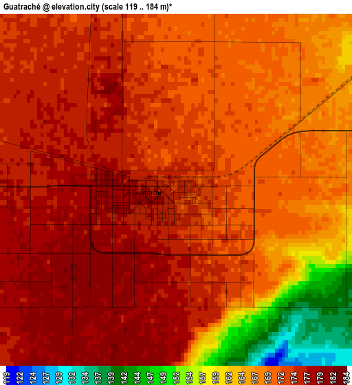
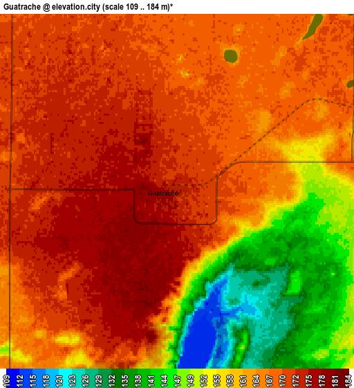
Below is the Elevation map of Guatraché, which displays elevation range with different colors. Scale of the first map is from 119 to 184 m (390 to 604 ft) with average elevation of 170.4 meters (=559 ft) [note 1]
These maps also provides idea of topography and contour of this city, they are displayed at different zoom levels. More info about maps, scale and edge coordinates you can find below images.
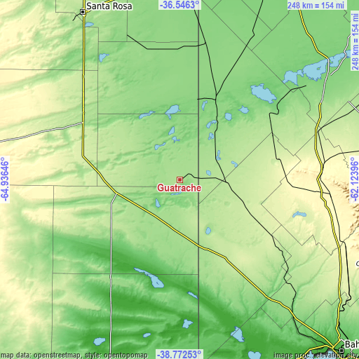
| \ | Map #1 | Map #2 | Topo.Map |
| Scale [m] | 119..184 m | 109..184 m | × |
| Scale [ft] | 390..604 ft | 358..604 ft | × |
| Average | 170.4 m = 559 ft | 163.4 m = 536 ft | × |
| Width | 7.74 km = 4.8 mi | 15.47 km = 9.6 mi | 247.5 km = 153.8 mi |
| Height | 7.74 km = 4.8 mi | 15.47 km = 9.6 mi | 247.5 km = 153.8 mi |
| ↑Max Latitude | -37.632966° | -37.598156° | -36.5463° |
| Latitude at center | -37.66776° | -37.66776° | -37.66776° |
| ↓Min Latitude | -37.702538° | -37.737299° | -38.77253° |
| ← Min Longitude | -63.574155° | -63.618101° | -64.93646° |
| Longitude center | -63.53021° | -63.53021° | -63.53021° |
| →Max Longitude | -63.486265° | -63.442319° | -62.12396° |
Nearby cities:
Cities around Guatraché sort by population:
• General Acha elevation 230 m
100.1 km,  288°
288°
• Macachín 143 m
60.3 km,  348°
348°
• General San Martín 165 m
35.2 km,  190°
190°
• Jacinto Arauz 162 m
47.3 km,  169°
169°
• Miguel Riglos 144 m
91.6 km, 351°
• Alpachiri 161 m
38.8 km,  326°
326°
• Doblas 161 m
71.6 km,  323°
323°
• Bernasconi 164 m
32.3 km,  215°
215°
• General Manuel J. Campos 159 m
23.6 km, 348°
• Pigüé 294 m
99.5 km,  85°
85°
• Carhué 110 m
87.4 km,  51°
51°
• Puan 231 m
68.6 km,  78°
78°
Multilingual:
 En español:
Guatraché elevación 174 m.
 En France:
Guatraché élévation 174 m.
 Auf Deutsch:
Guatraché höhe über dem Meeresspiegel ist 174 m.

Sources and notes:
- [note 1] Map square and city borders are not equal. Map elevation data is calculated only from area inside that square.
- [src 1] Elevation data from geonames database provided with same terms of usage.
- [src 2] The elevation map of Guatraché is generated using elevation data from NASA's 3 arcsec (90m) resolution SRTM data.
- [src 3] Base (background) map © OpenStreetMap contributors tiles are generated by Geofabrik and OpenTopoMap.
Copyright & License:
This Guatraché Elevation Map is licensed under CC BY-SA. You may reuse any part from this page, if you give a proper credit by linking to this URL:
 More info on terms of use page.