Las Coloradas elevation
Las Coloradas (Neuquen, Departamento de Catán-Lil), Argentina elevation is 913 meters and Las Coloradas elevation in feet is 2995 ft above sea level [src 1]. Las Coloradas is a seat of a second-order administrative division (feature code) with elevation that is 563 meters (1847 ft) bigger than average city elevation in Argentina.
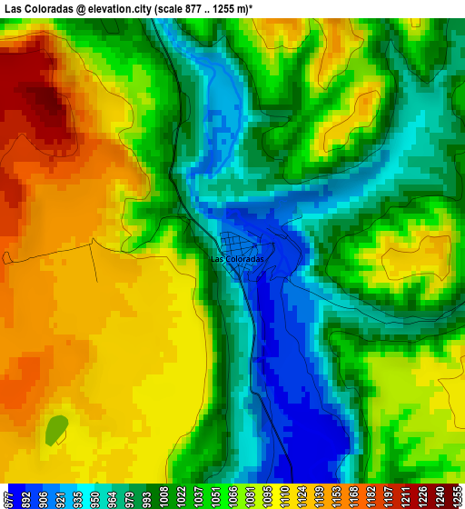
Below is the Elevation map of Las Coloradas, which displays elevation range with different colors. Scale of the first map is from 877 to 1255 m (2877 to 4117 ft) with average elevation of 1046.8 meters (=3434 ft) [note 1]
These maps also provides idea of topography and contour of this city, they are displayed at different zoom levels. More info about maps, scale and edge coordinates you can find below images.
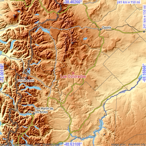
| \ | Map #1 | Topo.Map |
| Scale [m] | 877..1255 m | × |
| Scale [ft] | 2877..4117 ft | × |
| Average | 1046.8 m = 3434 ft | × |
| Width | 7.53 km = 4.7 mi | 241.1 km = 149.8 mi |
| Height | 7.53 km = 4.7 mi | 241.1 km = 149.8 mi |
| ↑Max Latitude | -39.521449° | -38.46266° |
| Latitude at center | -39.55534° | -39.55534° |
| ↓Min Latitude | -39.589214° | -40.63108° |
| ← Min Longitude | -70.638855° | -72.00116° |
| Longitude center | -70.59491° | -70.59491° |
| →Max Longitude | -70.550965° | -69.18866° |
Nearby cities:
Cities around Las Coloradas sort by population:
• Cutral-Có elevation 613 m
136.3 km,  59°
59°
• Zapala 1015 m
86.5 km,  32°
32°
• San Martín de los Andes 651 m
93.2 km,  224°
224°
• Plaza Huincul 600 m
138.4 km, 59°
• Junín de los Andes 779 m
59.8 km, 222°
• Villa La Angostura 796 m
161.2 km,  213°
213°
• Las Lajas 718 m
116.4 km,  9°
9°
• Loncopué 963 m
164.8 km,  359°
359°
• Aluminé 937 m
45.1 km,  321°
321°
• Piedra del Águila 505 m
70.6 km,  140°
140°
• Picún Leufú 386 m
112.2 km,  87°
87°
• Mariano Moreno 773 m
102.2 km, 28°
Multilingual:
 En español:
Las Coloradas elevación 913 m.
 En France:
Las Coloradas élévation 913 m.
 Auf Deutsch:
Las Coloradas höhe über dem Meeresspiegel ist 913 m.

Sources and notes:
- [note 1] Map square and city borders are not equal. Map elevation data is calculated only from area inside that square.
- [src 1] Elevation data from geonames database provided with same terms of usage.
- [src 2] The elevation map of Las Coloradas is generated using elevation data from NASA's 3 arcsec (90m) resolution SRTM data.
- [src 3] Base (background) map © OpenStreetMap contributors tiles are generated by Geofabrik and OpenTopoMap.
Copyright & License:
This Las Coloradas Elevation Map is licensed under CC BY-SA. You may reuse any part from this page, if you give a proper credit by linking to this URL:
 More info on terms of use page.