Los Menucos elevation
Los Menucos (Rio Negro, Departamento de Veinticinco de Mayo), Argentina elevation is 791 meters and Los Menucos elevation in feet is 2595 ft above sea level [src 1]. Los Menucos is a populated place (feature code) with elevation that is 441 meters (1447 ft) bigger than average city elevation in Argentina.
Below is the Elevation map of Los Menucos, which displays elevation range with different colors. Scale of the first map is from 765 to 983 m (2510 to 3225 ft) with average elevation of 808.3 meters (=2652 ft) [note 1]
These maps also provides idea of topography and contour of this city, they are displayed at different zoom levels. More info about maps, scale and edge coordinates you can find below images.
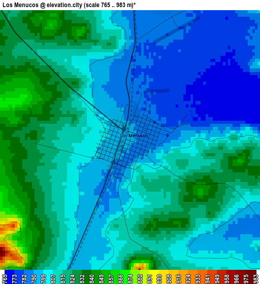
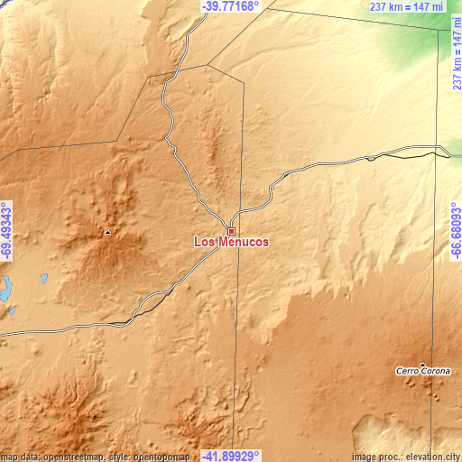
| \ | Map #1 | Topo.Map |
| Scale [m] | 765..983 m | × |
| Scale [ft] | 2510..3225 ft | × |
| Average | 808.3 m = 2652 ft | × |
| Width | 7.39 km = 4.6 mi | 236.6 km = 147 mi |
| Height | 7.39 km = 4.6 mi | 236.6 km = 147 mi |
| ↑Max Latitude | -40.810767° | -39.77168° |
| Latitude at center | -40.84402° | -40.84402° |
| ↓Min Latitude | -40.877256° | -41.89929° |
| ← Min Longitude | -68.131125° | -69.49343° |
| Longitude center | -68.08718° | -68.08718° |
| →Max Longitude | -68.043235° | -66.68093° |
Nearby cities:
Cities around Los Menucos sort by population:
• General Roca elevation 237 m
205.9 km,  12°
12°
• Senillosa 294 m
205.6 km,  351°
351°
• Ingeniero Jacobacci 872 m
133.9 km,  246°
246°
• Valcheta 185 m
163.1 km,  83°
83°
• Piedra del Águila 505 m
190 km,  297°
297°
• Picún Leufú 386 m
179.4 km,  325°
325°
• Maquinchao 898 m
68.5 km,  228°
228°
• Sierra Colorada 656 m
40.1 km,  44°
44°
• Comallo 772 m
184.3 km,  263°
263°
• Telsen 348 m
201 km,  151°
151°
• Gastre 1034 m
183.7 km,  210°
210°
• El Cuy 717 m
104.2 km, 348°
Multilingual:
 En español:
Los Menucos elevación 791 m.
 En France:
Los Menucos élévation 791 m.
 Auf Deutsch:
Los Menucos höhe über dem Meeresspiegel ist 791 m.

Sources and notes:
- [note 1] Map square and city borders are not equal. Map elevation data is calculated only from area inside that square.
- [src 1] Elevation data from geonames database provided with same terms of usage.
- [src 2] The elevation map of Los Menucos is generated using elevation data from NASA's 3 arcsec (90m) resolution SRTM data.
- [src 3] Base (background) map © OpenStreetMap contributors tiles are generated by Geofabrik and OpenTopoMap.
Copyright & License:
This Los Menucos Elevation Map is licensed under CC BY-SA. You may reuse any part from this page, if you give a proper credit by linking to this URL:
 More info on terms of use page.