Mendoza elevation
Mendoza, Argentina elevation is 746 meters and Mendoza elevation in feet is 2448 ft above sea level [src 1]. Mendoza is a seat of a first-order administrative division (feature code) with elevation that is 396 meters (1299 ft) bigger than average city elevation in Argentina.
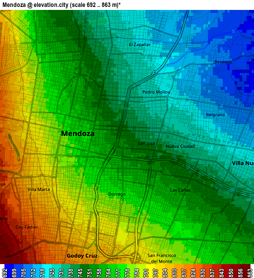
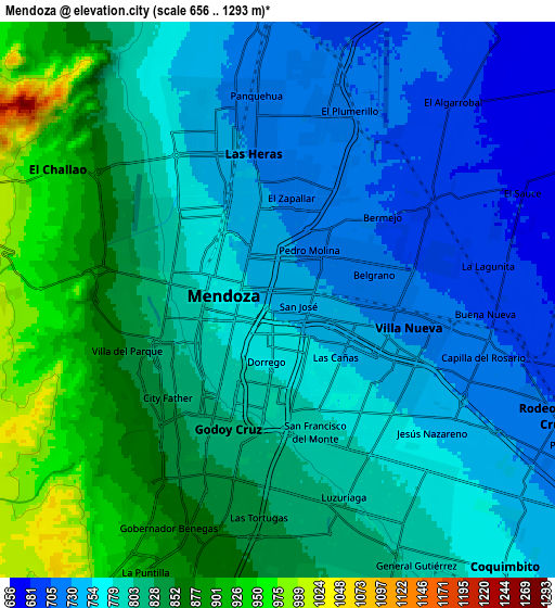
Below is the Elevation map of Mendoza, which displays elevation range with different colors. Scale of the first map is from 692 to 863 m (2270 to 2831 ft) with average elevation of 760.5 meters (=2495 ft) [note 1]
These maps also provides idea of topography and contour of this city, they are displayed at different zoom levels. More info about maps, scale and edge coordinates you can find below images.
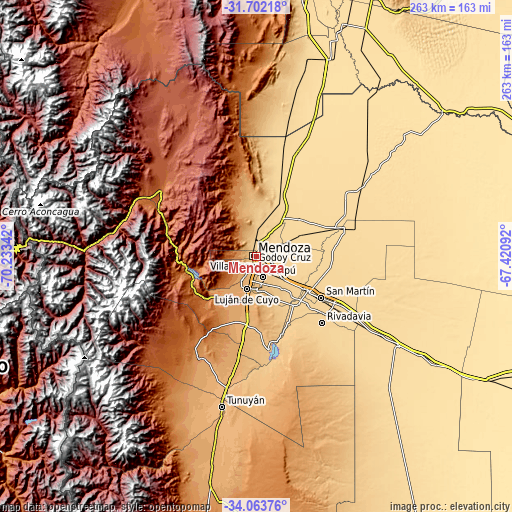
| \ | Map #1 | Map #2 | Topo.Map |
| Scale [m] | 692..863 m | 656..1293 m | × |
| Scale [ft] | 2270..2831 ft | 2152..4242 ft | × |
| Average | 760.5 m = 2495 ft | 795.9 m = 2611 ft | × |
| Width | 8.21 km = 5.1 mi | 16.41 km = 10.2 mi | 262.6 km = 163.2 mi |
| Height | 8.21 km = 5.1 mi | 16.41 km = 10.2 mi | 262.6 km = 163.2 mi |
| ↑Max Latitude | -32.853931° | -32.817007° | -31.70218° |
| Latitude at center | -32.89084° | -32.89084° | -32.89084° |
| ↓Min Latitude | -32.927733° | -32.964612° | -34.06376° |
| ← Min Longitude | -68.871115° | -68.915061° | -70.23342° |
| Longitude center | -68.82717° | -68.82717° | -68.82717° |
| →Max Longitude | -68.783225° | -68.739279° | -67.42092° |
Nearby cities:
Cities around Mendoza sort by population:
• San Martín elevation 661 m
39.6 km,  122°
122°
• Tunuyán 883 m
78.2 km,  192°
192°
• Santa Rosa 610 m
75 km, 122°
• Tupungato 1077 m
61.2 km,  209°
209°
• Rivadavia 667 m
47.7 km,  134°
134°
• Junín 669 m
43.2 km, 131°
• General Lavalle 609 m
28.9 km,  49°
49°
• Luján de Cuyo 955 m
16.8 km,  196°
196°
• Maipú 813 m
10.6 km,  158°
158°
• Villa Nueva 719 m
4.4 km,  99°
99°
• Godoy Cruz 809 m
4.3 km, 189°
• Las Heras 723 m
4.2 km,  358°
358°
Multilingual:
 En español:
Ciudad de Mendoza elevación 746 m.
 En France:
Mendoza élévation 746 m.


Sources and notes:
- [note 1] Map square and city borders are not equal. Map elevation data is calculated only from area inside that square.
- [src 1] Elevation data from geonames database provided with same terms of usage.
- [src 2] The elevation map of Mendoza is generated using elevation data from NASA's 3 arcsec (90m) resolution SRTM data.
- [src 3] Base (background) map © OpenStreetMap contributors tiles are generated by Geofabrik and OpenTopoMap.
Copyright & License:
This Mendoza Elevation Map is licensed under CC BY-SA. You may reuse any part from this page, if you give a proper credit by linking to this URL:
 More info on terms of use page.