Pérez elevation
Pérez (Santa Fe, Rosario Department), Argentina elevation is 37 meters and Pérez elevation in feet is 121 ft above sea level [src 1]. Pérez is a populated place (feature code) with elevation that is 313 meters (1027 ft) smaller than average city elevation in Argentina.
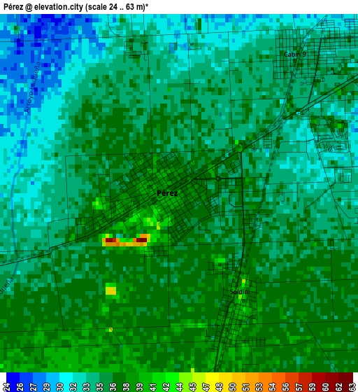
Below is the Elevation map of Pérez, which displays elevation range with different colors. Scale of the first map is from 24 to 63 m (79 to 207 ft) with average elevation of 34.7 meters (=114 ft) [note 1]
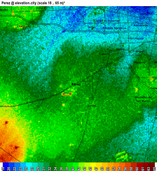
These maps also provides idea of topography and contour of this city, they are displayed at different zoom levels. More info about maps, scale and edge coordinates you can find below images.
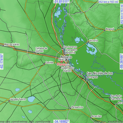
| \ | Map #1 | Map #2 | Topo.Map |
| Scale [m] | 24..63 m | 18..65 m | × |
| Scale [ft] | 79..207 ft | 59..213 ft | × |
| Average | 34.7 m = 114 ft | 33.9 m = 111 ft | × |
| Width | 8.2 km = 5.1 mi | 16.39 km = 10.2 mi | 262.3 km = 163 mi |
| Height | 8.2 km = 5.1 mi | 16.39 km = 10.2 mi | 262.3 km = 163 mi |
| ↑Max Latitude | -32.961486° | -32.924607° | -31.81111° |
| Latitude at center | -32.99835° | -32.99835° | -32.99835° |
| ↓Min Latitude | -33.035199° | -33.072032° | -34.16982° |
| ← Min Longitude | -60.811855° | -60.855801° | -62.17416° |
| Longitude center | -60.76791° | -60.76791° | -60.76791° |
| →Max Longitude | -60.723965° | -60.680019° | -59.36166° |
Nearby cities:
Cities around Pérez sort by population:
• Rosario elevation 38 m
13.3 km,  64°
64°
• Gobernador Gálvez 28 m
12.4 km,  106°
106°
• Granadero Baigorria 32 m
16.4 km,  16°
16°
• Casilda 79 m
37.7 km,  262°
262°
• Capitán Bermúdez 35 m
20.1 km,  13°
13°
• Arroyo Seco 29 m
29.8 km,  125°
125°
• Carcarañá 59 m
39.3 km,  293°
293°
• Funes 36 m
10 km,  336°
336°
• Fray Luis A. Beltrán 30 m
23.3 km, 9°
• Roldán 43 m
17.1 km,  310°
310°
• Villa Mugueta 85 m
43.9 km,  217°
217°
• San Lorenzo 30 m
28.5 km, 5°
Multilingual:
 En español:
Pérez elevación 37 m.
 En France:
Pérez élévation 37 m.


Sources and notes:
- [note 1] Map square and city borders are not equal. Map elevation data is calculated only from area inside that square.
- [src 1] Elevation data from geonames database provided with same terms of usage.
- [src 2] The elevation map of Pérez is generated using elevation data from NASA's 3 arcsec (90m) resolution SRTM data.
- [src 3] Base (background) map © OpenStreetMap contributors tiles are generated by Geofabrik and OpenTopoMap.
Copyright & License:
This Pérez Elevation Map is licensed under CC BY-SA. You may reuse any part from this page, if you give a proper credit by linking to this URL:
 More info on terms of use page.