Tinogasta elevation
Tinogasta (Catamarca, Departamento de Tinogasta), Argentina elevation is 1212 meters and Tinogasta elevation in feet is 3976 ft above sea level [src 1]. Tinogasta is a seat of a second-order administrative division (feature code) with elevation that is 862 meters (2828 ft) bigger than average city elevation in Argentina.
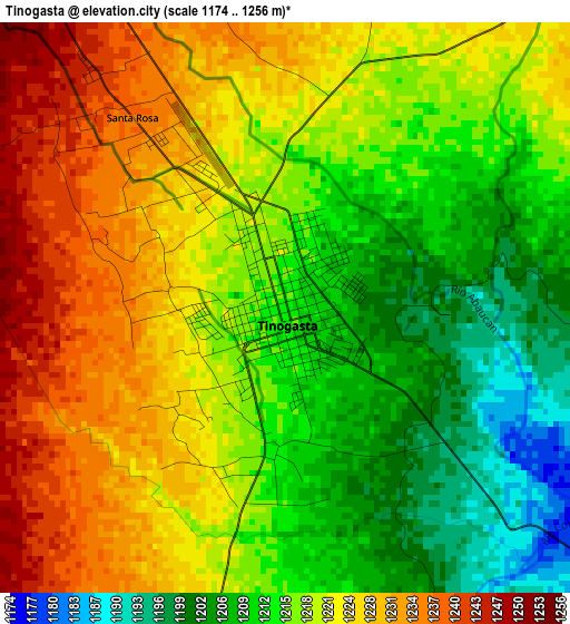
Below is the Elevation map of Tinogasta, which displays elevation range with different colors. Scale of the first map is from 1174 to 1256 m (3852 to 4121 ft) with average elevation of 1218.9 meters (=3999 ft) [note 1]
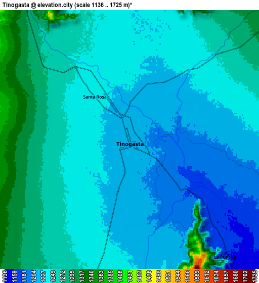
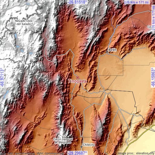
These maps also provides idea of topography and contour of this city, they are displayed at different zoom levels. More info about maps, scale and edge coordinates you can find below images.
| \ | Map #1 | Map #2 | Topo.Map |
| Scale [m] | 1174..1256 m | 1136..1725 m | × |
| Scale [ft] | 3852..4121 ft | 3727..5659 ft | × |
| Average | 1218.9 m = 3999 ft | 1242.9 m = 4078 ft | × |
| Width | 8.62 km = 5.4 mi | 17.25 km = 10.7 mi | 275.9 km = 171.4 mi |
| Height | 8.62 km = 5.4 mi | 17.25 km = 10.7 mi | 275.9 km = 171.4 mi |
| ↑Max Latitude | -28.024404° | -27.985605° | -26.81518° |
| Latitude at center | -28.06319° | -28.06319° | -28.06319° |
| ↓Min Latitude | -28.101962° | -28.140719° | -29.29687° |
| ← Min Longitude | -67.608825° | -67.652771° | -68.97113° |
| Longitude center | -67.56488° | -67.56488° | -67.56488° |
| →Max Longitude | -67.520935° | -67.476989° | -66.15863° |
Nearby cities:
Cities around Tinogasta sort by population:
• Arauco elevation 820 m
95 km,  127°
127°
• Fiambalá 1521 m
43.8 km,  353°
353°
• Vinchina 1460 m
99.7 km,  219°
219°
• Londres 1222 m
57.5 km,  47°
47°
• Hualfín 1842 m
117.6 km,  37°
37°
• Puerta de Corral Quemado 1884 m
111.4 km,  33°
33°
• La Puerta de San José 1434 m
78.5 km, 43°
• Aminga 1388 m
107 km,  144°
144°
• Famatina 1567 m
95.7 km,  177°
177°
• Aimogasta 846 m
92.6 km, 126°
• Belén 1262 m
69.8 km, 48°
• San Blas de los Sauces 1022 m
60.2 km, 129°
Multilingual:
 En español:
Tinogasta elevación 1212 m.
 En France:
Tinogasta élévation 1212 m.
 Auf Deutsch:
Tinogasta höhe über dem Meeresspiegel ist 1212 m.

Sources and notes:
- [note 1] Map square and city borders are not equal. Map elevation data is calculated only from area inside that square.
- [src 1] Elevation data from geonames database provided with same terms of usage.
- [src 2] The elevation map of Tinogasta is generated using elevation data from NASA's 3 arcsec (90m) resolution SRTM data.
- [src 3] Base (background) map © OpenStreetMap contributors tiles are generated by Geofabrik and OpenTopoMap.
Copyright & License:
This Tinogasta Elevation Map is licensed under CC BY-SA. You may reuse any part from this page, if you give a proper credit by linking to this URL:
 More info on terms of use page.