Boedo elevation
Boedo (Buenos Aires F.D., Comuna 5), Argentina elevation is 19 meters and Boedo elevation in feet is 62 ft above sea level [src 1]. Boedo is a section of populated place (feature code) with elevation that is 331 meters (1086 ft) smaller than average city elevation in Argentina.
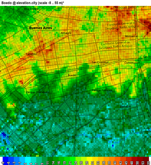
Below is the Elevation map of Boedo, which displays elevation range with different colors. Scale of the first map is from -8 to 55 m (-26 to 180 ft) with average elevation of 20 meters (=66 ft) [note 1]
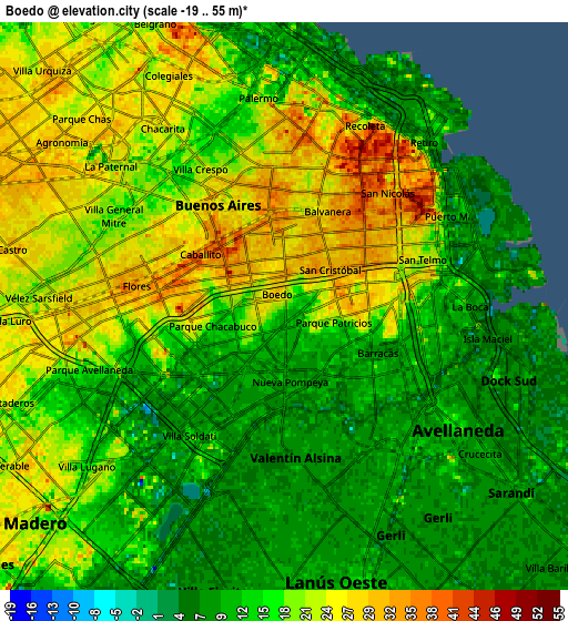
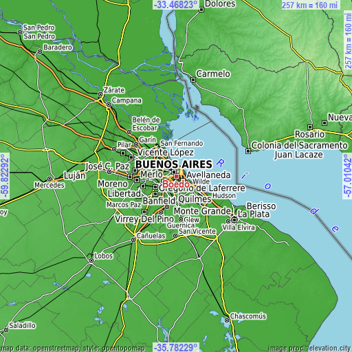
These maps also provides idea of topography and contour of this city, they are displayed at different zoom levels. More info about maps, scale and edge coordinates you can find below images.
| \ | Map #1 | Map #2 | Topo.Map |
| Scale [m] | -8..55 m | -19..55 m | × |
| Scale [ft] | -26..180 ft | -62..180 ft | × |
| Average | 20 m = 66 ft | 16.6 m = 54 ft | × |
| Width | 8.04 km = 5 mi | 16.08 km = 10 mi | 257.3 km = 159.9 mi |
| Height | 8.04 km = 5 mi | 16.08 km = 10 mi | 257.3 km = 159.9 mi |
| ↑Max Latitude | -34.597164° | -34.560982° | -33.46823° |
| Latitude at center | -34.63333° | -34.63333° | -34.63333° |
| ↓Min Latitude | -34.669481° | -34.705615° | -35.78229° |
| ← Min Longitude | -58.460615° | -58.504561° | -59.82292° |
| Longitude center | -58.41667° | -58.41667° | -58.41667° |
| →Max Longitude | -58.372725° | -58.328779° | -57.01042° |
Nearby cities:
Cities around Boedo sort by population:
• Buenos Aires elevation 31 m
4.2 km,  58°
58°
• Balvanera 35 m
3.1 km,  34°
34°
• Belgrano 18 m
8.7 km,  334°
334°
• Villa Lugano 19 m
7.2 km,  225°
225°
• Barracas 10 m
3.5 km,  120°
120°
• Colegiales 27 m
7.3 km,  335°
335°
• Retiro 7 m
6.3 km, 28°
• Villa Santa Rita 25 m
6.4 km,  293°
293°
• Villa Ortúzar 26 m
7.6 km,  321°
321°
• General San Martín 26 m
12.7 km,  301°
301°
• Lanús 10 m
7.9 km,  165°
165°
• Avellaneda 13 m
5.4 km, 123°
Multilingual:
 En español:
Boedo elevación 19 m.
 En France:
Boedo élévation 19 m.


Sources and notes:
- [note 1] Map square and city borders are not equal. Map elevation data is calculated only from area inside that square.
- [src 1] Elevation data from geonames database provided with same terms of usage.
- [src 2] The elevation map of Boedo is generated using elevation data from NASA's 3 arcsec (90m) resolution SRTM data.
- [src 3] Base (background) map © OpenStreetMap contributors tiles are generated by Geofabrik and OpenTopoMap.
Copyright & License:
This Boedo Elevation Map is licensed under CC BY-SA. You may reuse any part from this page, if you give a proper credit by linking to this URL:
 More info on terms of use page.