El Soberbio elevation
El Soberbio (Misiones, Departamento de Guaraní), Argentina elevation is 156 meters and El Soberbio elevation in feet is 512 ft above sea level [src 1]. El Soberbio is a seat of a second-order administrative division (feature code) with elevation that is 194 meters (636 ft) smaller than average city elevation in Argentina.
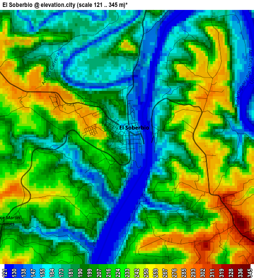
Below is the Elevation map of El Soberbio, which displays elevation range with different colors. Scale of the first map is from 121 to 345 m (397 to 1132 ft) with average elevation of 203.9 meters (=669 ft) [note 1]
These maps also provides idea of topography and contour of this city, they are displayed at different zoom levels. More info about maps, scale and edge coordinates you can find below images.
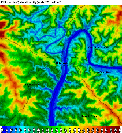
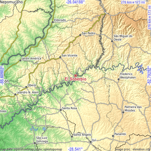
| \ | Map #1 | Map #2 | Topo.Map |
| Scale [m] | 121..345 m | 120..411 m | × |
| Scale [ft] | 397..1132 ft | 394..1348 ft | × |
| Average | 203.9 m = 669 ft | 231.7 m = 760 ft | × |
| Width | 8.68 km = 5.4 mi | 17.37 km = 10.8 mi | 277.9 km = 172.7 mi |
| Height | 8.68 km = 5.4 mi | 17.37 km = 10.8 mi | 277.9 km = 172.7 mi |
| ↑Max Latitude | -27.259412° | -27.22034° | -26.04188° |
| Latitude at center | -27.29847° | -27.29847° | -27.29847° |
| ↓Min Latitude | -27.337514° | -27.376545° | -28.541° |
| ← Min Longitude | -54.242715° | -54.286661° | -55.60502° |
| Longitude center | -54.19877° | -54.19877° | -54.19877° |
| →Max Longitude | -54.154825° | -54.110879° | -52.79252° |
Nearby cities:
Cities around El Soberbio sort by population:
• San Vicente elevation 603 m
76.1 km,  4°
4°
• San Pedro 554 m
75.7 km,  6°
6°
• Aristóbulo del Valle 494 m
72.6 km,  288°
288°
• Dos de Mayo 561 m
57.2 km,  302°
302°
• Campo Grande 454 m
77.9 km,  277°
277°
• Veinticinco de Mayo 396 m
54.5 km,  260°
260°
• Campo Ramón 364 m
83 km, 257°
• Campo Viera 342 m
84.8 km,  267°
267°
• Colonia Aurora 178 m
37.7 km,  238°
238°
• Alba Posse 125 m
56.5 km, 237°
• Panambí 121 m
85 km, 236°
• El Alcázar 210 m
89.1 km,  316°
316°
Multilingual:
 En español:
El Soberbio elevación 156 m.
 En France:
El Soberbio élévation 156 m.
 Auf Deutsch:
El Soberbio höhe über dem Meeresspiegel ist 156 m.

Sources and notes:
- [note 1] Map square and city borders are not equal. Map elevation data is calculated only from area inside that square.
- [src 1] Elevation data from geonames database provided with same terms of usage.
- [src 2] The elevation map of El Soberbio is generated using elevation data from NASA's 3 arcsec (90m) resolution SRTM data.
- [src 3] Base (background) map © OpenStreetMap contributors tiles are generated by Geofabrik and OpenTopoMap.
Copyright & License:
This El Soberbio Elevation Map is licensed under CC BY-SA. You may reuse any part from this page, if you give a proper credit by linking to this URL:
 More info on terms of use page.