Hasenkamp elevation
Hasenkamp (Entre Rios, Departamento de Paraná), Argentina elevation is 90 meters and Hasenkamp elevation in feet is 295 ft above sea level [src 1]. Hasenkamp is a populated place (feature code) with elevation that is 260 meters (853 ft) smaller than average city elevation in Argentina.
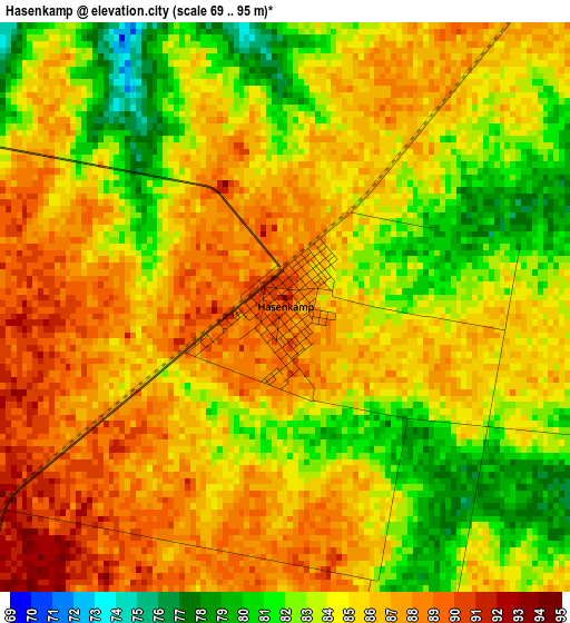
Below is the Elevation map of Hasenkamp, which displays elevation range with different colors. Scale of the first map is from 69 to 95 m (226 to 312 ft) with average elevation of 84.6 meters (=278 ft) [note 1]
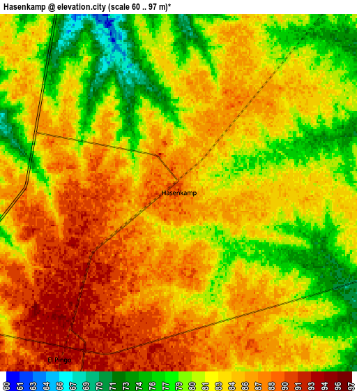
These maps also provides idea of topography and contour of this city, they are displayed at different zoom levels. More info about maps, scale and edge coordinates you can find below images.
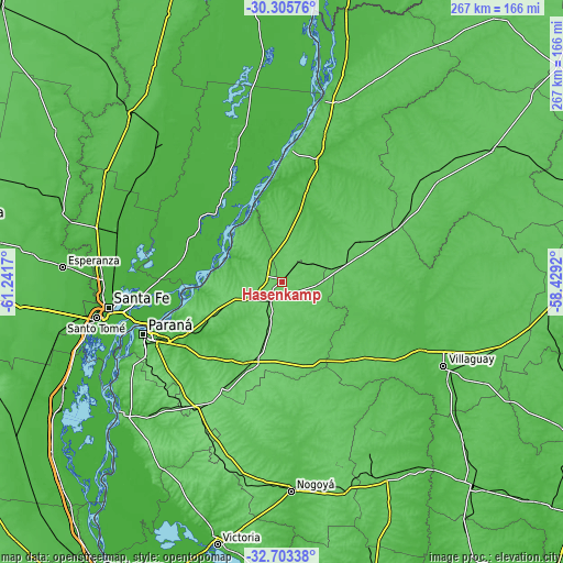
| \ | Map #1 | Map #2 | Topo.Map |
| Scale [m] | 69..95 m | 60..97 m | × |
| Scale [ft] | 226..312 ft | 197..318 ft | × |
| Average | 84.6 m = 278 ft | 83.1 m = 273 ft | × |
| Width | 8.33 km = 5.2 mi | 16.66 km = 10.4 mi | 266.6 km = 165.7 mi |
| Height | 8.33 km = 5.2 mi | 16.66 km = 10.4 mi | 266.6 km = 165.7 mi |
| ↑Max Latitude | -31.474788° | -31.437301° | -30.30576° |
| Latitude at center | -31.51226° | -31.51226° | -31.51226° |
| ↓Min Latitude | -31.549717° | -31.587159° | -32.70338° |
| ← Min Longitude | -59.879395° | -59.923341° | -61.2417° |
| Longitude center | -59.83545° | -59.83545° | -59.83545° |
| →Max Longitude | -59.791505° | -59.747559° | -58.4292° |
Nearby cities:
Cities around Hasenkamp sort by population:
• Santa Elena elevation 74 m
63.3 km,  4°
4°
• Viale 71 m
42.7 km,  202°
202°
• Bovril 81 m
41.5 km,  63°
63°
• Villa María Grande 94 m
18.2 km, 200°
• San Benito 61 m
64.8 km,  242°
242°
• Villa Hernandarias 52 m
34.3 km,  335°
335°
• Seguí 102 m
56.5 km,  208°
208°
• Sauce de Luna 76 m
66 km, 62°
• Piedras Blancas 46 m
37.9 km, 343°
• Villa Urquiza 51 m
53.3 km,  253°
253°
• Tabossi 100 m
33.5 km, 196°
• Helvecia 26 m
51.9 km,  332°
332°
Multilingual:
 En español:
Hasenkamp elevación 90 m.
 En France:
Hasenkamp élévation 90 m.
 Auf Deutsch:
Hasenkamp höhe über dem Meeresspiegel ist 90 m.

Sources and notes:
- [note 1] Map square and city borders are not equal. Map elevation data is calculated only from area inside that square.
- [src 1] Elevation data from geonames database provided with same terms of usage.
- [src 2] The elevation map of Hasenkamp is generated using elevation data from NASA's 3 arcsec (90m) resolution SRTM data.
- [src 3] Base (background) map © OpenStreetMap contributors tiles are generated by Geofabrik and OpenTopoMap.
Copyright & License:
This Hasenkamp Elevation Map is licensed under CC BY-SA. You may reuse any part from this page, if you give a proper credit by linking to this URL:
 More info on terms of use page.