Hurlingham elevation
Hurlingham (Buenos Aires, Partido de Hurlingham), Argentina elevation is 17 meters and Hurlingham elevation in feet is 56 ft above sea level [src 1]. Hurlingham is a seat of a second-order administrative division (feature code) with elevation that is 333 meters (1093 ft) smaller than average city elevation in Argentina.
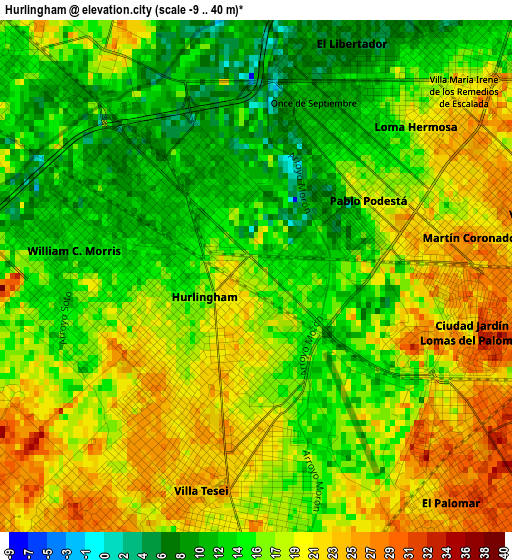
Below is the Elevation map of Hurlingham, which displays elevation range with different colors. Scale of the first map is from -9 to 40 m (-30 to 131 ft) with average elevation of 17 meters (=56 ft) [note 1]
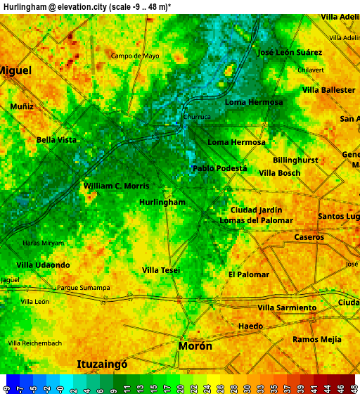
These maps also provides idea of topography and contour of this city, they are displayed at different zoom levels. More info about maps, scale and edge coordinates you can find below images.
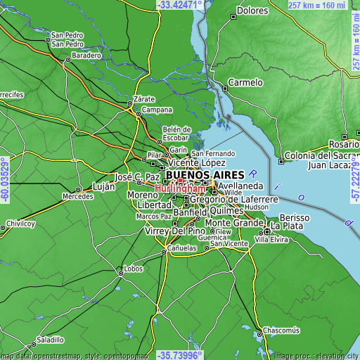
| \ | Map #1 | Map #2 | Topo.Map |
| Scale [m] | -9..40 m | -9..48 m | × |
| Scale [ft] | -30..131 ft | -30..157 ft | × |
| Average | 17 m = 56 ft | 21.4 m = 70 ft | × |
| Width | 8.04 km = 5 mi | 16.09 km = 10 mi | 257.4 km = 159.9 mi |
| Height | 8.05 km = 5 mi | 16.09 km = 10 mi | 257.4 km = 159.9 mi |
| ↑Max Latitude | -34.554215° | -34.518014° | -33.42471° |
| Latitude at center | -34.5904° | -34.5904° | -34.5904° |
| ↓Min Latitude | -34.626569° | -34.662723° | -35.73996° |
| ← Min Longitude | -58.672985° | -58.716931° | -60.03529° |
| Longitude center | -58.62904° | -58.62904° | -58.62904° |
| →Max Longitude | -58.585095° | -58.541149° | -57.22279° |
Nearby cities:
Cities around Hurlingham sort by population:
• Morón elevation 29 m
6.8 km,  172°
172°
• Merlo 21 m
12.5 km,  227°
227°
• San Miguel 30 m
9.2 km,  304°
304°
• Don Torcuato 15 m
10.7 km,  0°
0°
• Los Polvorines 28 m
12 km,  324°
324°
• Villa de Mayo 16 m
10 km,  331°
331°
• Villa Santa Rita 25 m
13.7 km,  99°
99°
• Muñiz 31 m
8.1 km, 297°
• San Justo 35 m
11.4 km,  146°
146°
• General San Martín 26 m
8.8 km,  78°
78°
• Ituzaingó 31 m
8.1 km,  202°
202°
• Caseros 35 m
6.1 km, 103°
Multilingual:
 En español:
Hurlingham elevación 17 m.
 En France:
Hurlingham élévation 17 m.
 Auf Deutsch:
Hurlingham höhe über dem Meeresspiegel ist 17 m.

Sources and notes:
- [note 1] Map square and city borders are not equal. Map elevation data is calculated only from area inside that square.
- [src 1] Elevation data from geonames database provided with same terms of usage.
- [src 2] The elevation map of Hurlingham is generated using elevation data from NASA's 3 arcsec (90m) resolution SRTM data.
- [src 3] Base (background) map © OpenStreetMap contributors tiles are generated by Geofabrik and OpenTopoMap.
Copyright & License:
This Hurlingham Elevation Map is licensed under CC BY-SA. You may reuse any part from this page, if you give a proper credit by linking to this URL:
 More info on terms of use page.