Puerto Iguazú elevation
Puerto Iguazú (Misiones, Departamento de Iguazú), Argentina elevation is 177 meters and Puerto Iguazú elevation in feet is 581 ft above sea level [src 1]. Puerto Iguazú is a seat of a fourth-order administrative division (feature code) with elevation that is 173 meters (568 ft) smaller than average city elevation in Argentina.
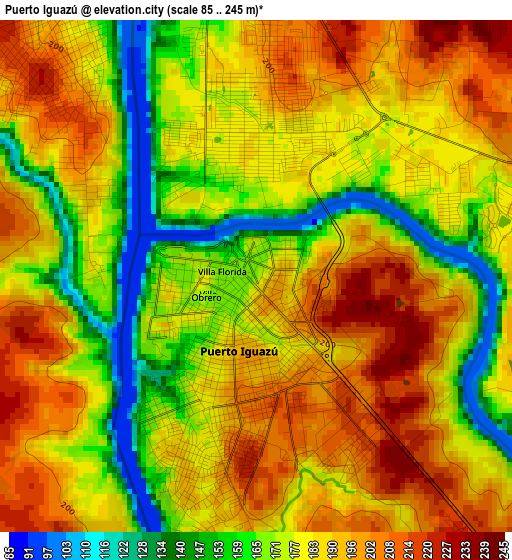
Below is the Elevation map of Puerto Iguazú, which displays elevation range with different colors. Scale of the first map is from 85 to 245 m (279 to 804 ft) with average elevation of 182.1 meters (=597 ft) [note 1]
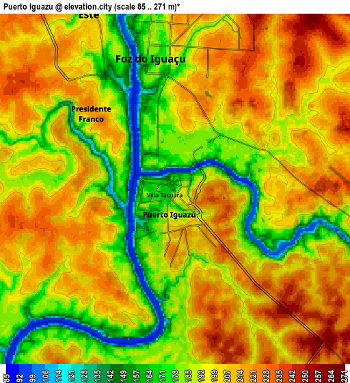
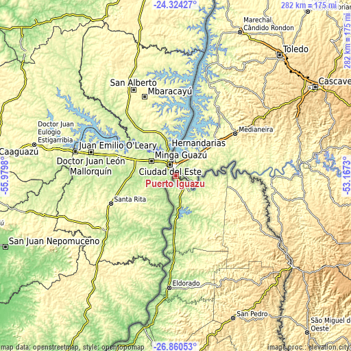
These maps also provides idea of topography and contour of this city, they are displayed at different zoom levels. More info about maps, scale and edge coordinates you can find below images.
| \ | Map #1 | Map #2 | Topo.Map |
| Scale [m] | 85..245 m | 85..271 m | × |
| Scale [ft] | 279..804 ft | 279..889 ft | × |
| Average | 182.1 m = 597 ft | 197.1 m = 647 ft | × |
| Width | 8.81 km = 5.5 mi | 17.63 km = 11 mi | 282 km = 175.2 mi |
| Height | 8.81 km = 5.5 mi | 17.63 km = 11 mi | 282 km = 175.2 mi |
| ↑Max Latitude | -25.559482° | -25.519831° | -24.32427° |
| Latitude at center | -25.59912° | -25.59912° | -25.59912° |
| ↓Min Latitude | -25.638745° | -25.678357° | -26.86053° |
| ← Min Longitude | -54.617495° | -54.661441° | -55.9798° |
| Longitude center | -54.57355° | -54.57355° | -54.57355° |
| →Max Longitude | -54.529605° | -54.485659° | -53.1673° |
Nearby cities:
Cities around Puerto Iguazú sort by population:
• Puerto Eldorado elevation 102 m
90.8 km,  187°
187°
• San Vicente 603 m
121.4 km,  158°
158°
• San Pedro 554 m
122.9 km, 157°
• Montecarlo 205 m
109.1 km, 189°
• Puerto Esperanza 152 m
47.3 km,  184°
184°
• Wanda 206 m
41.1 km, 178°
• Bernardo de Irigoyen 815 m
118 km,  128°
128°
• Puerto Piray 137 m
97.7 km, 187°
• Puerto Libertad 101 m
35.6 km, 181°
• El Alcázar 210 m
126.4 km, 191°
• Caraguatay 126 m
113.8 km, 190°
• Eldorado 233 m
89.7 km, 183°
Multilingual:
 En español:
Puerto Iguazú elevación 177 m.
 En France:
Puerto Iguazú élévation 177 m.
 Auf Deutsch:
Puerto Iguazú höhe über dem Meeresspiegel ist 177 m.

Sources and notes:
- [note 1] Map square and city borders are not equal. Map elevation data is calculated only from area inside that square.
- [src 1] Elevation data from geonames database provided with same terms of usage.
- [src 2] The elevation map of Puerto Iguazú is generated using elevation data from NASA's 3 arcsec (90m) resolution SRTM data.
- [src 3] Base (background) map © OpenStreetMap contributors tiles are generated by Geofabrik and OpenTopoMap.
Copyright & License:
This Puerto Iguazú Elevation Map is licensed under CC BY-SA. You may reuse any part from this page, if you give a proper credit by linking to this URL:
 More info on terms of use page.