Santa María elevation
Santa María (Misiones, Departamento de Concepción de la Sierra), Argentina elevation is 137 meters and Santa María elevation in feet is 449 ft above sea level [src 1]. Santa María is a populated place (feature code) with elevation that is 213 meters (699 ft) smaller than average city elevation in Argentina.
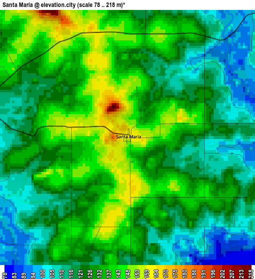
Below is the Elevation map of Santa María, which displays elevation range with different colors. Scale of the first map is from 78 to 218 m (256 to 715 ft) with average elevation of 127.6 meters (=419 ft) [note 1]
These maps also provides idea of topography and contour of this city, they are displayed at different zoom levels. More info about maps, scale and edge coordinates you can find below images.
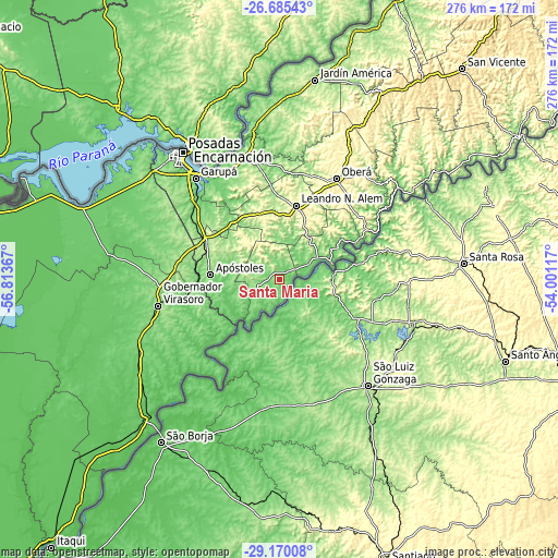
| \ | Map #1 | Topo.Map |
| Scale [m] | 78..218 m | × |
| Scale [ft] | 256..715 ft | × |
| Average | 127.6 m = 419 ft | × |
| Width | 8.63 km = 5.4 mi | 276.3 km = 171.7 mi |
| Height | 8.63 km = 5.4 mi | 276.3 km = 171.7 mi |
| ↑Max Latitude | -27.896068° | -26.68543° |
| Latitude at center | -27.9349° | -27.9349° |
| ↓Min Latitude | -27.973718° | -29.17008° |
| ← Min Longitude | -55.451365° | -56.81367° |
| Longitude center | -55.40742° | -55.40742° |
| →Max Longitude | -55.363475° | -54.00117° |
Nearby cities:
Cities around Santa María sort by population:
• Concepción de la Sierra elevation 167 m
12.3 km,  244°
244°
• Cerro Azul 263 m
34.7 km,  345°
345°
• Azara 127 m
30.1 km, 242°
• Dos Arroyos 287 m
30.3 km,  30°
30°
• Picada Gobernador López 299 m
33.4 km, 28°
• Mojón Grande 327 m
35 km,  44°
44°
• Arroyo del Medio 287 m
26.4 km,  0°
0°
• Tres Capones 157 m
20.9 km,  247°
247°
• Garruchos 80 m
35.8 km,  222°
222°
• Leandro N. Alem 296 m
37.7 km,  12°
12°
• Apóstoles 179 m
34.1 km,  273°
273°
• San Javier 112 m
27.6 km,  75°
75°
Multilingual:
 En español:
Santa María elevación 137 m.
 En France:
Santa María élévation 137 m.
 Auf Deutsch:
Santa María höhe über dem Meeresspiegel ist 137 m.

Sources and notes:
- [note 1] Map square and city borders are not equal. Map elevation data is calculated only from area inside that square.
- [src 1] Elevation data from geonames database provided with same terms of usage.
- [src 2] The elevation map of Santa María is generated using elevation data from NASA's 3 arcsec (90m) resolution SRTM data.
- [src 3] Base (background) map © OpenStreetMap contributors tiles are generated by Geofabrik and OpenTopoMap.
Copyright & License:
This Santa María Elevation Map is licensed under CC BY-SA. You may reuse any part from this page, if you give a proper credit by linking to this URL:
 More info on terms of use page.