Longonjo elevation
Longonjo (Huambo), Angola elevation is 1424 meters and Longonjo elevation in feet is 4672 ft above sea level [src 1]. Longonjo is a populated place (feature code) with elevation that is 455 meters (1493 ft) bigger than average city elevation in Angola.
Below is the Elevation map of Longonjo, which displays elevation range with different colors. Scale of the first map is from 1404 to 1751 m (4606 to 5745 ft) with average elevation of 1483.6 meters (=4867 ft) [note 1]
These maps also provides idea of topography and contour of this city, they are displayed at different zoom levels. More info about maps, scale and edge coordinates you can find below images.
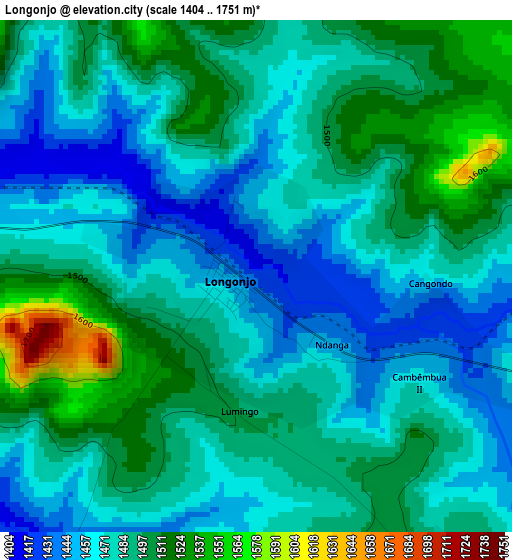
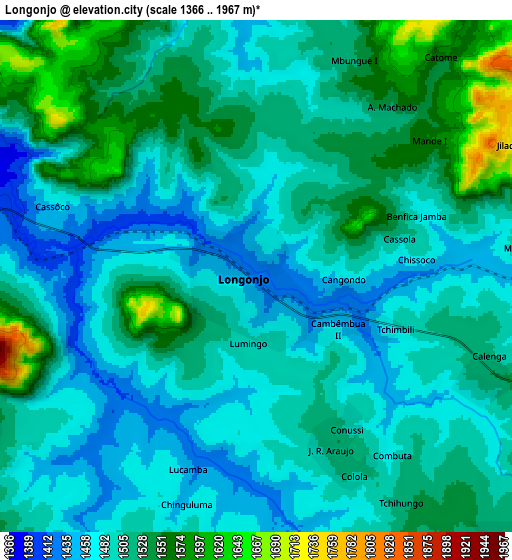
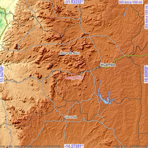
| \ | Map #1 | Map #2 | Topo.Map |
| Scale [m] | 1404..1751 m | 1366..1967 m | × |
| Scale [ft] | 4606..5745 ft | 4482..6453 ft | × |
| Average | 1483.6 m = 4867 ft | 1504.9 m = 4937 ft | × |
| Width | 9.53 km = 5.9 mi | 19.05 km = 11.8 mi | 304.8 km = 189.4 mi |
| Height | 9.53 km = 5.9 mi | 19.05 km = 11.8 mi | 304.8 km = 189.4 mi |
| ↑Max Latitude | -12.863831° | -12.820985° | -11.53232° |
| Latitude at center | -12.90667° | -12.90667° | -12.90667° |
| ↓Min Latitude | -12.949501° | -12.992325° | -14.27351° |
| ← Min Longitude | 15.209385° | 15.165439° | 13.84708° |
| Longitude center | 15.25333° | 15.25333° | 15.25333° |
| →Max Longitude | 15.297275° | 15.341221° | 16.65958° |
Nearby cities:
Cities around Longonjo sort by population:
• Huambo elevation 1716 m
54.6 km,  74°
74°
• Lobito 4 m
195.8 km,  287°
287°
• Benguela 11 m
203.7 km,  280°
280°
• Cuito 1715 m
191.3 km, 72°
• Caála 1742 m
33.8 km,  79°
79°
• Catabola 1531 m
235.9 km, 69°
• Catumbela 12 m
192.6 km, 285°
• Uacu Cungo 1304 m
173 km,  355°
355°
• Caconda 1674 m
94.1 km,  192°
192°
• Chissamba 1404 m
240.3 km, 69°
• Chela 1716 m
70 km,  16°
16°
• Chinjenje 1895 m
28.4 km,  264°
264°
Multilingual:
 En español:
Longonjo elevación 1424 m.
 En France:
Longonjo élévation 1424 m.
 Auf Deutsch:
Longonjo höhe über dem Meeresspiegel ist 1424 m.

Sources and notes:
- [note 1] Map square and city borders are not equal. Map elevation data is calculated only from area inside that square.
- [src 1] Elevation data from geonames database provided with same terms of usage.
- [src 2] The elevation map of Longonjo is generated using elevation data from NASA's 3 arcsec (90m) resolution SRTM data.
- [src 3] Base (background) map © OpenStreetMap contributors tiles are generated by Geofabrik and OpenTopoMap.
Copyright & License:
This Longonjo Elevation Map is licensed under CC BY-SA. You may reuse any part from this page, if you give a proper credit by linking to this URL:
 More info on terms of use page.