Abovyan elevation
Abovyan (Kotayk), Armenia elevation is 1423 meters and Abovyan elevation in feet is 4669 ft above sea level [src 1]. Abovyan is a populated place (feature code) with elevation that is 125 meters (410 ft) bigger than average city elevation in Armenia.
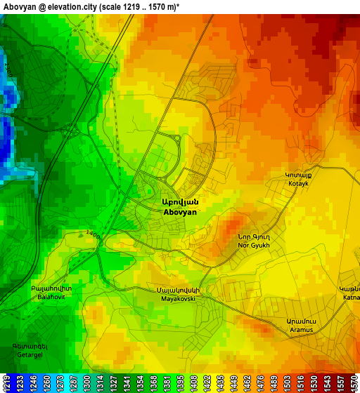
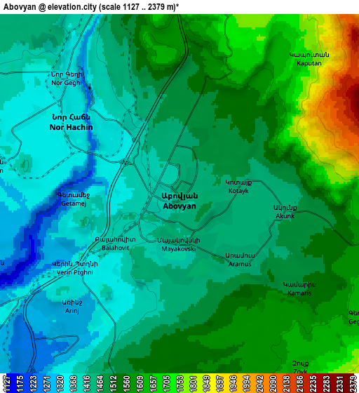
Below is the Elevation map of Abovyan, which displays elevation range with different colors. Scale of the first map is from 1219 to 1570 m (3999 to 5151 ft) with average elevation of 1423.6 meters (=4671 ft) [note 1]
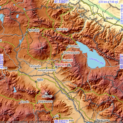
These maps also provides idea of topography and contour of this city, they are displayed at different zoom levels. More info about maps, scale and edge coordinates you can find below images.
| \ | Map #1 | Map #2 | Topo.Map |
| Scale [m] | 1219..1570 m | 1127..2379 m | × |
| Scale [ft] | 3999..5151 ft | 3698..7805 ft | × |
| Average | 1423.6 m = 4671 ft | 1490.6 m = 4890 ft | × |
| Width | 7.46 km = 4.6 mi | 14.91 km = 9.3 mi | 238.6 km = 148.3 mi |
| Height | 7.46 km = 4.6 mi | 14.91 km = 9.3 mi | 238.6 km = 148.3 mi |
| ↑Max Latitude | 40.3072° | 40.340704° | 41.33807° |
| Latitude at center | 40.27368° | 40.27368° | 40.27368° |
| ↓Min Latitude | 40.240143° | 40.206589° | 39.19227° |
| ← Min Longitude | 44.589535° | 44.545589° | 43.22723° |
| Longitude center | 44.63348° | 44.63348° | 44.63348° |
| →Max Longitude | 44.677425° | 44.721371° | 46.03973° |
Nearby cities:
Cities around Abovyan sort by population:
• Byureghavan elevation 1385 m
5.6 km,  322°
322°
• Nor Geghi 1313 m
6.9 km, 321°
• Aramus 1441 m
3.6 km,  134°
134°
• Balahovit 1409 m
3.3 km,  220°
220°
• Arzni 1349 m
4 km,  311°
311°
• Dzoraghbyur 1549 m
7.8 km,  174°
174°
• Akunk’ 1459 m
4.5 km,  99°
99°
• Mayakovski 1418 m
2.4 km, 168°
• Mrgashen 1335 m
7.7 km,  280°
280°
• Kotayk’ 1443 m
2.6 km,  79°
79°
• Nor Gyugh 1432 m
2.2 km,  110°
110°
• Ptghni 1336 m
4.5 km,  243°
243°
Multilingual:
 En español:
Abovyan elevación 1423 m.
 En France:
Abovyan élévation 1423 m.
 Auf Deutsch:
Abowjan höhe über dem Meeresspiegel ist 1423 m.

Sources and notes:
- [note 1] Map square and city borders are not equal. Map elevation data is calculated only from area inside that square.
- [src 1] Elevation data from geonames database provided with same terms of usage.
- [src 2] The elevation map of Abovyan is generated using elevation data from NASA's 3 arcsec (90m) resolution SRTM data.
- [src 3] Base (background) map © OpenStreetMap contributors tiles are generated by Geofabrik and OpenTopoMap.
Copyright & License:
This Abovyan Elevation Map is licensed under CC BY-SA. You may reuse any part from this page, if you give a proper credit by linking to this URL:
 More info on terms of use page.