Alaverdi elevation
Alaverdi (Lori), Armenia elevation is 699 meters and Alaverdi elevation in feet is 2293 ft above sea level [src 1]. Alaverdi is a populated place (feature code) with elevation that is 599 meters (1965 ft) smaller than average city elevation in Armenia.
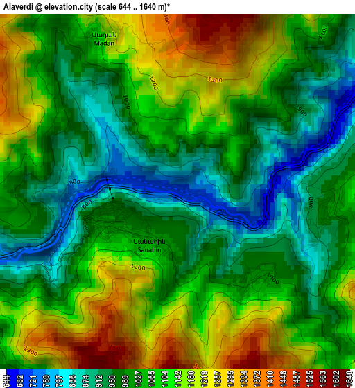
Below is the Elevation map of Alaverdi, which displays elevation range with different colors. Scale of the first map is from 644 to 1640 m (2113 to 5381 ft) with average elevation of 1056.7 meters (=3467 ft) [note 1]
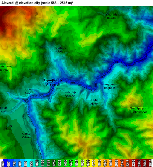
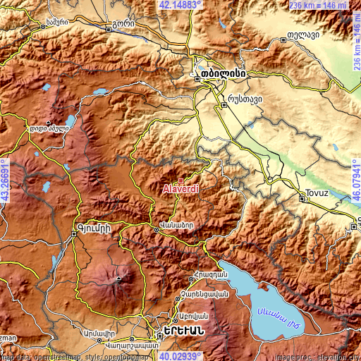
These maps also provides idea of topography and contour of this city, they are displayed at different zoom levels. More info about maps, scale and edge coordinates you can find below images.
| \ | Map #1 | Map #2 | Topo.Map |
| Scale [m] | 644..1640 m | 583..2515 m | × |
| Scale [ft] | 2113..5381 ft | 1913..8251 ft | × |
| Average | 1056.7 m = 3467 ft | 1284.5 m = 4214 ft | × |
| Width | 7.36 km = 4.6 mi | 14.73 km = 9.2 mi | 235.7 km = 146.5 mi |
| Height | 7.36 km = 4.6 mi | 14.73 km = 9.2 mi | 235.7 km = 146.5 mi |
| ↑Max Latitude | 41.130768° | 41.16386° | 42.14883° |
| Latitude at center | 41.09766° | 41.09766° | 41.09766° |
| ↓Min Latitude | 41.064535° | 41.031393° | 40.02939° |
| ← Min Longitude | 44.629215° | 44.585269° | 43.26691° |
| Longitude center | 44.67316° | 44.67316° | 44.67316° |
| →Max Longitude | 44.717105° | 44.761051° | 46.07941° |
Nearby cities:
Cities around Alaverdi sort by population:
• Odzun elevation 1107 m
7 km,  225°
225°
• Bagratashen 440 m
20.2 km,  36°
36°
• Shnogh 640 m
15 km,  68°
68°
• Dsegh 1216 m
15.2 km,  187°
187°
• Akht’ala 1214 m
10.6 km, 42°
• Chochkan 767 m
16.2 km,  55°
55°
• Vardablur 1318 m
19.7 km,  224°
224°
• Agarak 1375 m
19.7 km,  240°
240°
• Archis 754 m
18.5 km, 66°
• Vahagni 1076 m
21.9 km, 194°
• Yeghegnut 1096 m
21.9 km, 189°
• Lorut 1499 m
19.7 km,  155°
155°
Multilingual:
 En español:
Alaverdi elevación 699 m.
 En France:
Alaverdi élévation 699 m.
 Auf Deutsch:
Alawerdi höhe über dem Meeresspiegel ist 699 m.

Sources and notes:
- [note 1] Map square and city borders are not equal. Map elevation data is calculated only from area inside that square.
- [src 1] Elevation data from geonames database provided with same terms of usage.
- [src 2] The elevation map of Alaverdi is generated using elevation data from NASA's 3 arcsec (90m) resolution SRTM data.
- [src 3] Base (background) map © OpenStreetMap contributors tiles are generated by Geofabrik and OpenTopoMap.
Copyright & License:
This Alaverdi Elevation Map is licensed under CC BY-SA. You may reuse any part from this page, if you give a proper credit by linking to this URL:
 More info on terms of use page.