Garrni elevation
Garrni (Kotayk), Armenia elevation is 1413 meters and Garrni elevation in feet is 4636 ft above sea level [src 1]. Garrni is a populated place (feature code) with elevation that is 115 meters (377 ft) bigger than average city elevation in Armenia.
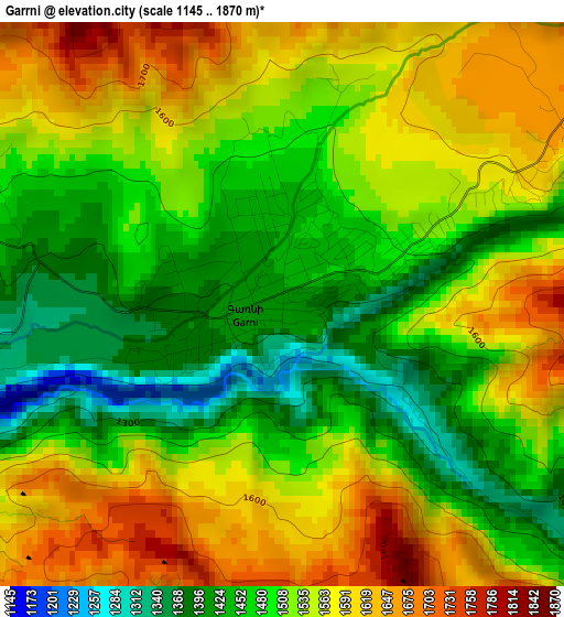
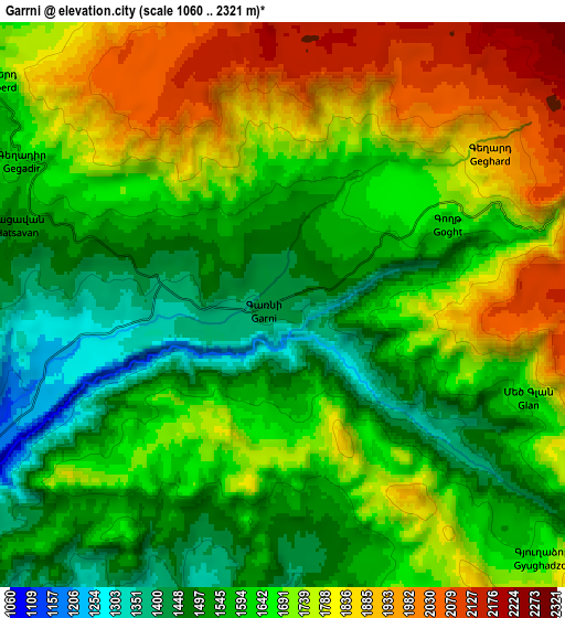
Below is the Elevation map of Garrni, which displays elevation range with different colors. Scale of the first map is from 1145 to 1870 m (3757 to 6135 ft) with average elevation of 1521.7 meters (=4992 ft) [note 1]
These maps also provides idea of topography and contour of this city, they are displayed at different zoom levels. More info about maps, scale and edge coordinates you can find below images.
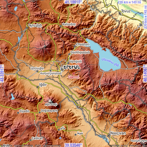
| \ | Map #1 | Map #2 | Topo.Map |
| Scale [m] | 1145..1870 m | 1060..2321 m | × |
| Scale [ft] | 3757..6135 ft | 3478..7615 ft | × |
| Average | 1521.7 m = 4992 ft | 1661.7 m = 5452 ft | × |
| Width | 7.47 km = 4.6 mi | 14.95 km = 9.3 mi | 239.1 km = 148.6 mi |
| Height | 7.47 km = 4.6 mi | 14.95 km = 9.3 mi | 239.1 km = 148.6 mi |
| ↑Max Latitude | 40.152907° | 40.186487° | 41.18615° |
| Latitude at center | 40.11931° | 40.11931° | 40.11931° |
| ↓Min Latitude | 40.085697° | 40.052066° | 39.03546° |
| ← Min Longitude | 44.690475° | 44.646529° | 43.32817° |
| Longitude center | 44.73442° | 44.73442° | 44.73442° |
| →Max Longitude | 44.778365° | 44.822311° | 46.14067° |
Nearby cities:
Cities around Garrni sort by population:
• Aramus elevation 1441 m
15.8 km,  337°
337°
• Dvin 928 m
16.9 km,  229°
229°
• Dzoraghbyur 1549 m
12.3 km,  320°
320°
• Getazat 939 m
17.1 km,  238°
238°
• Goght’ 1578 m
4.5 km,  67°
67°
• Verin Dvin 955 m
16.2 km, 229°
• Akunk’ 1459 m
16.9 km,  345°
345°
• Mayakovski 1418 m
16.9 km,  331°
331°
• Nor Gyugh 1432 m
17.6 km, 338°
• Abovyan 956 m
17.7 km, 243°
• Zarr 1622 m
15.5 km,  359°
359°
• Bardzrashen 1154 m
13.7 km,  253°
253°
Multilingual:
 En español:
Garrni elevación 1413 m.
 En France:
Garrni élévation 1413 m.


Sources and notes:
- [note 1] Map square and city borders are not equal. Map elevation data is calculated only from area inside that square.
- [src 1] Elevation data from geonames database provided with same terms of usage.
- [src 2] The elevation map of Garrni is generated using elevation data from NASA's 3 arcsec (90m) resolution SRTM data.
- [src 3] Base (background) map © OpenStreetMap contributors tiles are generated by Geofabrik and OpenTopoMap.
Copyright & License:
This Garrni Elevation Map is licensed under CC BY-SA. You may reuse any part from this page, if you give a proper credit by linking to this URL:
 More info on terms of use page.