Metsamor elevation
Metsamor (Armavir), Armenia elevation is 840 meters and Metsamor elevation in feet is 2756 ft above sea level [src 1]. Metsamor is a populated place (feature code) with elevation that is 458 meters (1503 ft) smaller than average city elevation in Armenia.
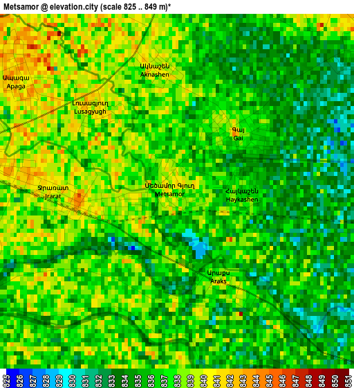
Below is the Elevation map of Metsamor, which displays elevation range with different colors. Scale of the first map is from 825 to 849 m (2707 to 2785 ft) with average elevation of 836.4 meters (=2744 ft) [note 1]
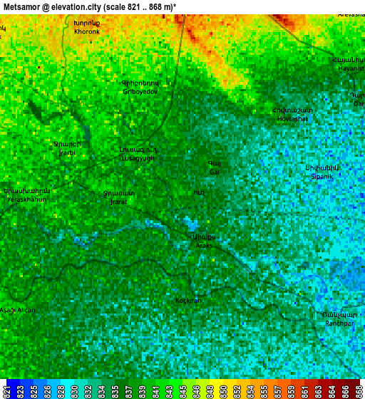
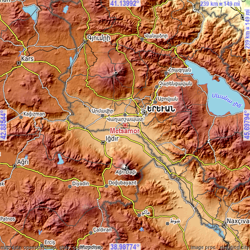
These maps also provides idea of topography and contour of this city, they are displayed at different zoom levels. More info about maps, scale and edge coordinates you can find below images.
| \ | Map #1 | Map #2 | Topo.Map |
| Scale [m] | 825..849 m | 821..868 m | × |
| Scale [ft] | 2707..2785 ft | 2694..2848 ft | × |
| Average | 836.4 m = 2744 ft | 837.4 m = 2747 ft | × |
| Width | 7.48 km = 4.6 mi | 14.96 km = 9.3 mi | 239.3 km = 148.7 mi |
| Height | 7.48 km = 4.6 mi | 14.96 km = 9.3 mi | 239.3 km = 148.7 mi |
| ↑Max Latitude | 40.10595° | 40.139554° | 41.13992° |
| Latitude at center | 40.07233° | 40.07233° | 40.07233° |
| ↓Min Latitude | 40.038693° | 40.00504° | 38.98774° |
| ← Min Longitude | 44.247745° | 44.203799° | 42.88544° |
| Longitude center | 44.29169° | 44.29169° | 44.29169° |
| →Max Longitude | 44.335635° | 44.379581° | 45.69794° |
Nearby cities:
Cities around Metsamor sort by population:
• Hovtashat elevation 836 m
5.3 km,  58°
58°
• Gay 840 m
1.8 km,  40°
40°
• Voskehat 857 m
8.4 km,  23°
23°
• Khoronk’ 858 m
8 km,  331°
331°
• Griboyedov 845 m
4.8 km,  339°
339°
• Apaga 843 m
4.3 km,  310°
310°
• Artimet 859 m
8.9 km,  346°
346°
• Arak’s 837 m
2.1 km,  152°
152°
• Aknashen 838 m
2.6 km, 349°
• Yeraskhahun 843 m
6.1 km,  270°
270°
• Haykashen 837 m
1.4 km,  90°
90°
• Sis 829 m
8.4 km,  100°
100°
Multilingual:
 En español:
Metsamor elevación 840 m.
 En France:
Metsamor élévation 840 m.
 Auf Deutsch:
Metsamor höhe über dem Meeresspiegel ist 840 m.

Sources and notes:
- [note 1] Map square and city borders are not equal. Map elevation data is calculated only from area inside that square.
- [src 1] Elevation data from geonames database provided with same terms of usage.
- [src 2] The elevation map of Metsamor is generated using elevation data from NASA's 3 arcsec (90m) resolution SRTM data.
- [src 3] Base (background) map © OpenStreetMap contributors tiles are generated by Geofabrik and OpenTopoMap.
Copyright & License:
This Metsamor Elevation Map is licensed under CC BY-SA. You may reuse any part from this page, if you give a proper credit by linking to this URL:
 More info on terms of use page.