Nerk’in Getashen elevation
Nerk’in Getashen (Gegharkunik), Armenia elevation is 1936 meters and Nerk’in Getashen elevation in feet is 6352 ft above sea level [src 1]. Nerk’in Getashen is a populated place (feature code) with elevation that is 638 meters (2093 ft) bigger than average city elevation in Armenia.
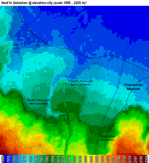
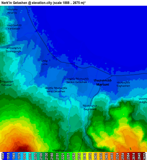
Below is the Elevation map of Nerk’in Getashen, which displays elevation range with different colors. Scale of the first map is from 1898 to 2205 m (6227 to 7234 ft) with average elevation of 1973.1 meters (=6473 ft) [note 1]
These maps also provides idea of topography and contour of this city, they are displayed at different zoom levels. More info about maps, scale and edge coordinates you can find below images.
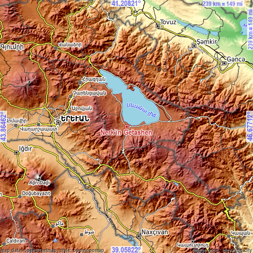
| \ | Map #1 | Map #2 | Topo.Map |
| Scale [m] | 1898..2205 m | 1888..2675 m | × |
| Scale [ft] | 6227..7234 ft | 6194..8776 ft | × |
| Average | 1973.1 m = 6473 ft | 2045.9 m = 6712 ft | × |
| Width | 7.47 km = 4.6 mi | 14.94 km = 9.3 mi | 239.1 km = 148.6 mi |
| Height | 7.47 km = 4.6 mi | 14.94 km = 9.3 mi | 239.1 km = 148.6 mi |
| ↑Max Latitude | 40.175306° | 40.208875° | 41.20821° |
| Latitude at center | 40.14172° | 40.14172° | 40.14172° |
| ↓Min Latitude | 40.108118° | 40.074499° | 39.05822° |
| ← Min Longitude | 45.226925° | 45.182979° | 43.86462° |
| Longitude center | 45.27087° | 45.27087° | 45.27087° |
| →Max Longitude | 45.314815° | 45.358761° | 46.67712° |
Nearby cities:
Cities around Nerk’in Getashen sort by population:
• Martuni elevation 1935 m
3 km,  96°
96°
• Vardenik 1971 m
14.7 km,  93°
93°
• Karanlukh 2111 m
4.4 km,  158°
158°
• Yeranos 1982 m
9.7 km,  316°
316°
• Verin Getashen 1980 m
2 km,  231°
231°
• Lichk’ 1930 m
3.6 km,  302°
302°
• Dzoragyugh 2016 m
8.1 km,  292°
292°
• Astghadzor 2035 m
7.5 km,  106°
106°
• Vaghashen 1957 m
5.1 km, 96°
• Tsovasar 2100 m
6.8 km,  266°
266°
• Vardadzor 1997 m
8.4 km,  306°
306°
• Madina 2169 m
7.4 km,  190°
190°
Multilingual:
 En español:
Nerk’in Getashen elevación 1936 m.
 En France:
Nerk’in Getashen élévation 1936 m.
 Auf Deutsch:
Nerk’in Getashen höhe über dem Meeresspiegel ist 1936 m.

Sources and notes:
- [note 1] Map square and city borders are not equal. Map elevation data is calculated only from area inside that square.
- [src 1] Elevation data from geonames database provided with same terms of usage.
- [src 2] The elevation map of Nerk’in Getashen is generated using elevation data from NASA's 3 arcsec (90m) resolution SRTM data.
- [src 3] Base (background) map © OpenStreetMap contributors tiles are generated by Geofabrik and OpenTopoMap.
Copyright & License:
This Nerk’in Getashen Elevation Map is licensed under CC BY-SA. You may reuse any part from this page, if you give a proper credit by linking to this URL:
 More info on terms of use page.