Step’anavan elevation
Step’anavan (Lori), Armenia elevation is 1405 meters and Step’anavan elevation in feet is 4610 ft above sea level [src 1]. Step’anavan is a populated place (feature code) with elevation that is 107 meters (351 ft) bigger than average city elevation in Armenia.
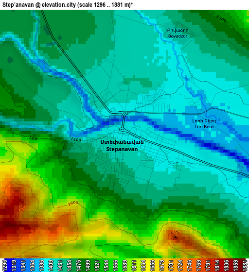
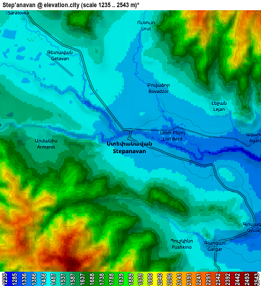
Below is the Elevation map of Step’anavan, which displays elevation range with different colors. Scale of the first map is from 1296 to 1881 m (4252 to 6171 ft) with average elevation of 1483.8 meters (=4868 ft) [note 1]
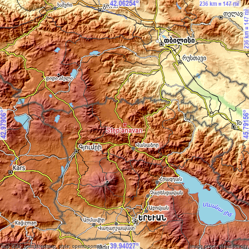
These maps also provides idea of topography and contour of this city, they are displayed at different zoom levels. More info about maps, scale and edge coordinates you can find below images.
| \ | Map #1 | Map #2 | Topo.Map |
| Scale [m] | 1296..1881 m | 1235..2543 m | × |
| Scale [ft] | 4252..6171 ft | 4052..8343 ft | × |
| Average | 1483.8 m = 4868 ft | 1609.3 m = 5280 ft | × |
| Width | 7.37 km = 4.6 mi | 14.75 km = 9.2 mi | 236 km = 146.6 mi |
| Height | 7.37 km = 4.6 mi | 14.75 km = 9.2 mi | 236 km = 146.6 mi |
| ↑Max Latitude | 41.043103° | 41.076238° | 42.06254° |
| Latitude at center | 41.00995° | 41.00995° | 41.00995° |
| ↓Min Latitude | 40.976781° | 40.943595° | 39.94027° |
| ← Min Longitude | 44.341365° | 44.297419° | 42.97906° |
| Longitude center | 44.38531° | 44.38531° | 44.38531° |
| →Max Longitude | 44.429255° | 44.473201° | 45.79156° |
Nearby cities:
Cities around Step’anavan sort by population:
• Tashir elevation 1505 m
14.9 km,  325°
325°
• Odzun 1107 m
19.7 km,  75°
75°
• Arevashogh 1680 m
19.1 km,  209°
209°
• Gyulagarak 1366 m
8.7 km,  123°
123°
• Darpas 1377 m
19.5 km,  170°
170°
• Norashen 1586 m
20.4 km,  347°
347°
• Sarahart’ 1733 m
21.2 km,  222°
222°
• Vardablur 1318 m
11.2 km,  112°
112°
• Agarak 1375 m
7 km,  89°
89°
• Bazum 1521 m
16.5 km,  163°
163°
• Urrut 1459 m
6.5 km,  8°
8°
• Gogaran 1849 m
20.4 km,  230°
230°
Multilingual:
 En español:
Step’anavan elevación 1405 m.
 En France:
Step’anavan élévation 1405 m.
 Auf Deutsch:
Step’anavan höhe über dem Meeresspiegel ist 1405 m.

Sources and notes:
- [note 1] Map square and city borders are not equal. Map elevation data is calculated only from area inside that square.
- [src 1] Elevation data from geonames database provided with same terms of usage.
- [src 2] The elevation map of Step’anavan is generated using elevation data from NASA's 3 arcsec (90m) resolution SRTM data.
- [src 3] Base (background) map © OpenStreetMap contributors tiles are generated by Geofabrik and OpenTopoMap.
Copyright & License:
This Step’anavan Elevation Map is licensed under CC BY-SA. You may reuse any part from this page, if you give a proper credit by linking to this URL:
 More info on terms of use page.