Vagharshapat elevation
Vagharshapat (Armavir), Armenia elevation is 877 meters and Vagharshapat elevation in feet is 2877 ft above sea level [src 1]. Vagharshapat is a populated place (feature code) with elevation that is 421 meters (1381 ft) smaller than average city elevation in Armenia.
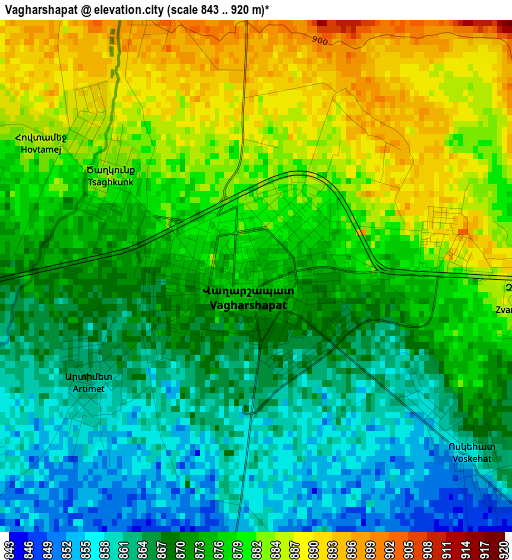
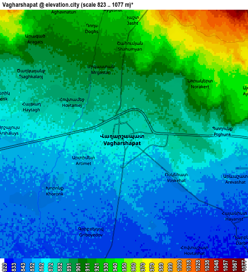
Below is the Elevation map of Vagharshapat, which displays elevation range with different colors. Scale of the first map is from 843 to 920 m (2766 to 3018 ft) with average elevation of 873.6 meters (=2866 ft) [note 1]
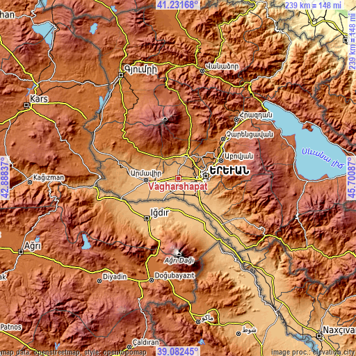
These maps also provides idea of topography and contour of this city, they are displayed at different zoom levels. More info about maps, scale and edge coordinates you can find below images.
| \ | Map #1 | Map #2 | Topo.Map |
| Scale [m] | 843..920 m | 823..1077 m | × |
| Scale [ft] | 2766..3018 ft | 2700..3533 ft | × |
| Average | 873.6 m = 2866 ft | 883.8 m = 2900 ft | × |
| Width | 7.47 km = 4.6 mi | 14.94 km = 9.3 mi | 239 km = 148.5 mi |
| Height | 7.47 km = 4.6 mi | 14.94 km = 9.3 mi | 239 km = 148.5 mi |
| ↑Max Latitude | 40.199144° | 40.232701° | 41.23168° |
| Latitude at center | 40.16557° | 40.16557° | 40.16557° |
| ↓Min Latitude | 40.131979° | 40.098372° | 39.08245° |
| ← Min Longitude | 44.250675° | 44.206729° | 42.88837° |
| Longitude center | 44.29462° | 44.29462° | 44.29462° |
| →Max Longitude | 44.338565° | 44.382511° | 45.70087° |
Nearby cities:
Cities around Vagharshapat sort by population:
• Arshaluys elevation 868 m
6.9 km,  273°
273°
• Norakert 942 m
5.9 km,  53°
53°
• Geghakert 883 m
4.9 km,  296°
296°
• Voskehat 857 m
4.1 km,  130°
130°
• Khoronk’ 858 m
5.2 km,  230°
230°
• Griboyedov 845 m
6.2 km,  198°
198°
• Artimet 859 m
2.9 km, 234°
• Ptghunk’ 868 m
5.9 km,  91°
91°
• Doghs 926 m
6.6 km,  343°
343°
• Tsaghkunk’ 886 m
2.5 km,  311°
311°
• Tsiatsan 886 m
3.1 km,  316°
316°
• Hovtamej 885 m
3.6 km, 302°
Multilingual:
 En español:
Vagharshapat elevación 877 m.
 En France:
Etchmiadzin élévation 877 m.
 Auf Deutsch:
Etschmiadsin höhe über dem Meeresspiegel ist 877 m.

Sources and notes:
- [note 1] Map square and city borders are not equal. Map elevation data is calculated only from area inside that square.
- [src 1] Elevation data from geonames database provided with same terms of usage.
- [src 2] The elevation map of Vagharshapat is generated using elevation data from NASA's 3 arcsec (90m) resolution SRTM data.
- [src 3] Base (background) map © OpenStreetMap contributors tiles are generated by Geofabrik and OpenTopoMap.
Copyright & License:
This Vagharshapat Elevation Map is licensed under CC BY-SA. You may reuse any part from this page, if you give a proper credit by linking to this URL:
 More info on terms of use page.