Aygavan elevation
Aygavan (Ararat), Armenia elevation is 847 meters and Aygavan elevation in feet is 2779 ft above sea level [src 1]. Aygavan is a populated place (feature code) with elevation that is 451 meters (1480 ft) smaller than average city elevation in Armenia.
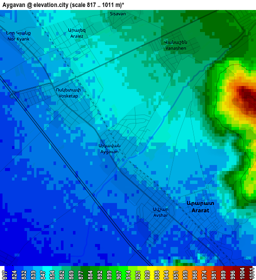
Below is the Elevation map of Aygavan, which displays elevation range with different colors. Scale of the first map is from 817 to 1011 m (2680 to 3317 ft) with average elevation of 849.8 meters (=2788 ft) [note 1]
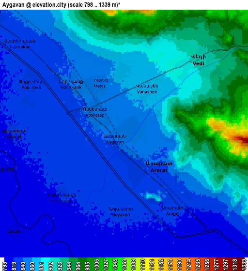
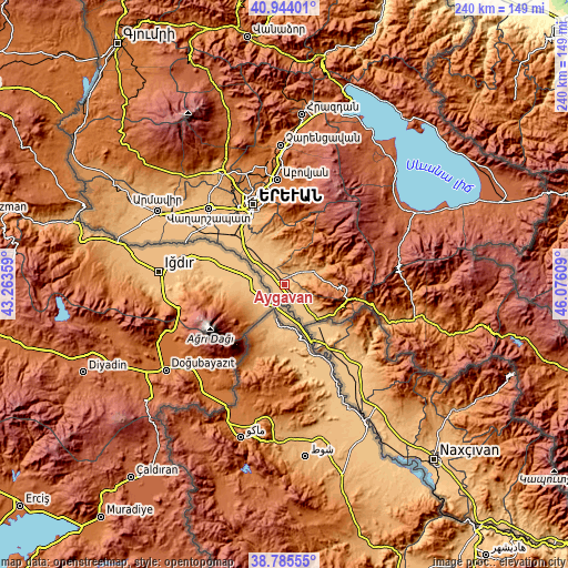
These maps also provides idea of topography and contour of this city, they are displayed at different zoom levels. More info about maps, scale and edge coordinates you can find below images.
| \ | Map #1 | Map #2 | Topo.Map |
| Scale [m] | 817..1011 m | 798..1339 m | × |
| Scale [ft] | 2680..3317 ft | 2618..4393 ft | × |
| Average | 849.8 m = 2788 ft | 867.7 m = 2847 ft | × |
| Width | 7.5 km = 4.7 mi | 15 km = 9.3 mi | 240 km = 149.1 mi |
| Height | 7.5 km = 4.7 mi | 15 km = 9.3 mi | 240 km = 149.1 mi |
| ↑Max Latitude | 39.906988° | 39.94069° | 40.94401° |
| Latitude at center | 39.87327° | 39.87327° | 39.87327° |
| ↓Min Latitude | 39.839535° | 39.805784° | 38.78555° |
| ← Min Longitude | 44.625895° | 44.581949° | 43.26359° |
| Longitude center | 44.66984° | 44.66984° | 44.66984° |
| →Max Longitude | 44.713785° | 44.757731° | 46.07609° |
Nearby cities:
Cities around Aygavan sort by population:
• Ararat elevation 823 m
5.6 km,  147°
147°
• Vedi 914 m
6.5 km,  46°
46°
• Avshar 832 m
2.2 km,  206°
206°
• Vosketap’ 841 m
2 km,  296°
296°
• Aygezard 877 m
10.7 km,  327°
327°
• Lusarrat 821 m
7.1 km,  270°
270°
• Aralez 856 m
3.2 km,  337°
337°
• Goravan 922 m
6.7 km, 54°
• Sisavan 865 m
3.9 km,  356°
356°
• Noyakert 827 m
4.7 km,  180°
180°
• Aygepat 880 m
11.2 km, 327°
• Yeghegnavan 816 m
5.7 km,  228°
228°
Multilingual:
 En español:
Aygavan elevación 847 m.
 En France:
Aygavan élévation 847 m.


Sources and notes:
- [note 1] Map square and city borders are not equal. Map elevation data is calculated only from area inside that square.
- [src 1] Elevation data from geonames database provided with same terms of usage.
- [src 2] The elevation map of Aygavan is generated using elevation data from NASA's 3 arcsec (90m) resolution SRTM data.
- [src 3] Base (background) map © OpenStreetMap contributors tiles are generated by Geofabrik and OpenTopoMap.
Copyright & License:
This Aygavan Elevation Map is licensed under CC BY-SA. You may reuse any part from this page, if you give a proper credit by linking to this URL:
 More info on terms of use page.