Malishka elevation
Malishka (Vayots Dzor), Armenia elevation is 1260 meters and Malishka elevation in feet is 4134 ft above sea level [src 1]. Malishka is a populated place (feature code) with elevation that is 38 meters (125 ft) smaller than average city elevation in Armenia.
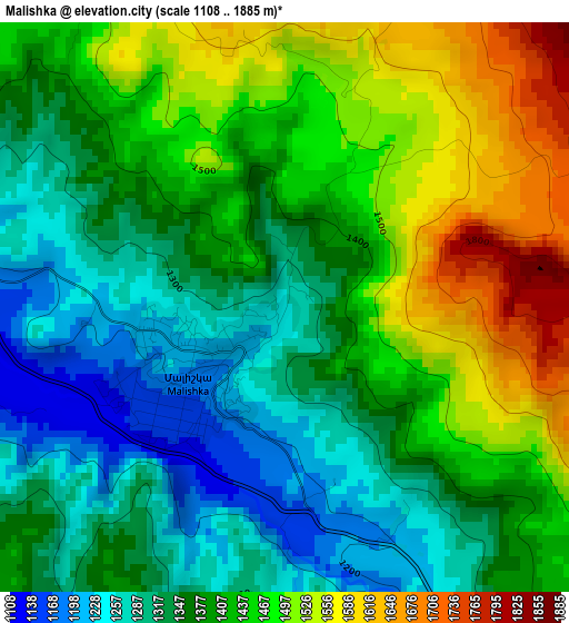
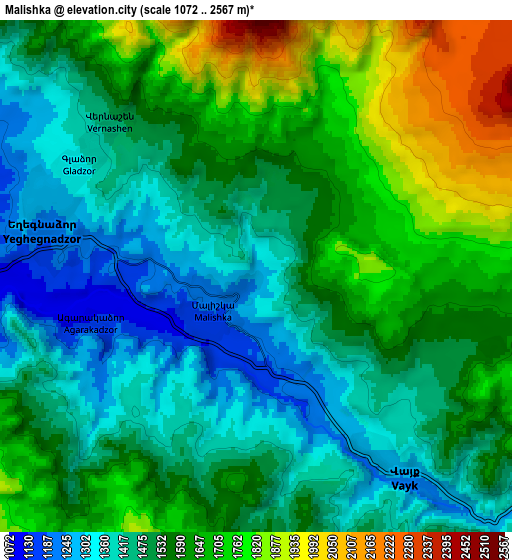
Below is the Elevation map of Malishka, which displays elevation range with different colors. Scale of the first map is from 1108 to 1885 m (3635 to 6184 ft) with average elevation of 1400.5 meters (=4595 ft) [note 1]
These maps also provides idea of topography and contour of this city, they are displayed at different zoom levels. More info about maps, scale and edge coordinates you can find below images.
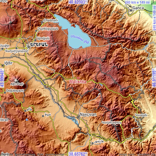
| \ | Map #1 | Map #2 | Topo.Map |
| Scale [m] | 1108..1885 m | 1072..2567 m | × |
| Scale [ft] | 3635..6184 ft | 3517..8422 ft | × |
| Average | 1400.5 m = 4595 ft | 1553.5 m = 5097 ft | × |
| Width | 7.51 km = 4.7 mi | 15.03 km = 9.3 mi | 240.4 km = 149.4 mi |
| Height | 7.51 km = 4.7 mi | 15.03 km = 9.3 mi | 240.4 km = 149.4 mi |
| ↑Max Latitude | 39.78109° | 39.814853° | 40.82003° |
| Latitude at center | 39.74731° | 39.74731° | 39.74731° |
| ↓Min Latitude | 39.713513° | 39.6797° | 38.65762° |
| ← Min Longitude | 45.361755° | 45.317809° | 43.99945° |
| Longitude center | 45.4057° | 45.4057° | 45.4057° |
| →Max Longitude | 45.449645° | 45.493591° | 46.81195° |
Nearby cities:
Cities around Malishka sort by population:
• Yeghegnadzor elevation 1242 m
6.5 km,  286°
286°
• Vayk’ 1237 m
8.3 km,  141°
141°
• Gladzor 1378 m
6.2 km,  306°
306°
• Aghavnadzor 1553 m
15.8 km, 285°
• Getap’ 1118 m
8.5 km,  282°
282°
• Areni 1081 m
19.3 km,  259°
259°
• Shatin 1276 m
13.2 km,  318°
318°
• Rrind 1316 m
19.5 km,  274°
274°
• Zarrit’ap’ 1512 m
15.1 km, 143°
• Agarakadzor 1143 m
4.5 km,  253°
253°
• Vernashen 1543 m
6.2 km, 324°
• Yeghegis 1573 m
14.7 km,  341°
341°
Multilingual:
 En español:
Malishka elevación 1260 m.
 En France:
Malishka élévation 1260 m.
 Auf Deutsch:
Malishka höhe über dem Meeresspiegel ist 1260 m.

Sources and notes:
- [note 1] Map square and city borders are not equal. Map elevation data is calculated only from area inside that square.
- [src 1] Elevation data from geonames database provided with same terms of usage.
- [src 2] The elevation map of Malishka is generated using elevation data from NASA's 3 arcsec (90m) resolution SRTM data.
- [src 3] Base (background) map © OpenStreetMap contributors tiles are generated by Geofabrik and OpenTopoMap.
Copyright & License:
This Malishka Elevation Map is licensed under CC BY-SA. You may reuse any part from this page, if you give a proper credit by linking to this URL:
 More info on terms of use page.