Shahumyan elevation
Shahumyan (Ararat), Armenia elevation is 832 meters and Shahumyan elevation in feet is 2730 ft above sea level [src 1]. Shahumyan is a populated place (feature code) with elevation that is 466 meters (1529 ft) smaller than average city elevation in Armenia.
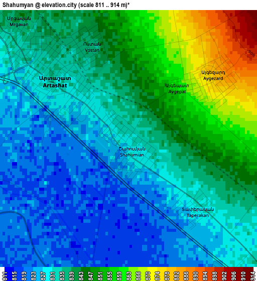
Below is the Elevation map of Shahumyan, which displays elevation range with different colors. Scale of the first map is from 811 to 914 m (2661 to 2999 ft) with average elevation of 837 meters (=2746 ft) [note 1]
These maps also provides idea of topography and contour of this city, they are displayed at different zoom levels. More info about maps, scale and edge coordinates you can find below images.
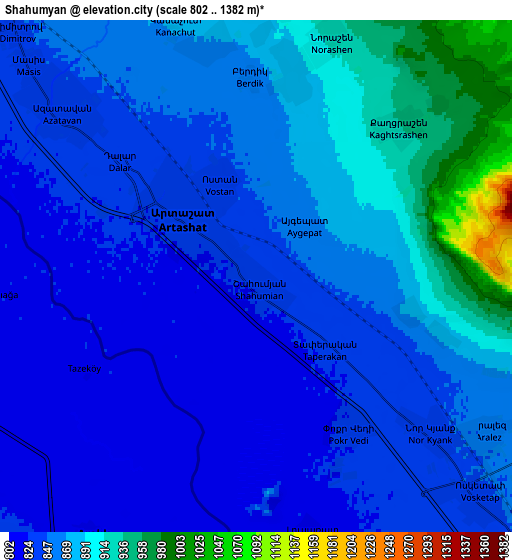
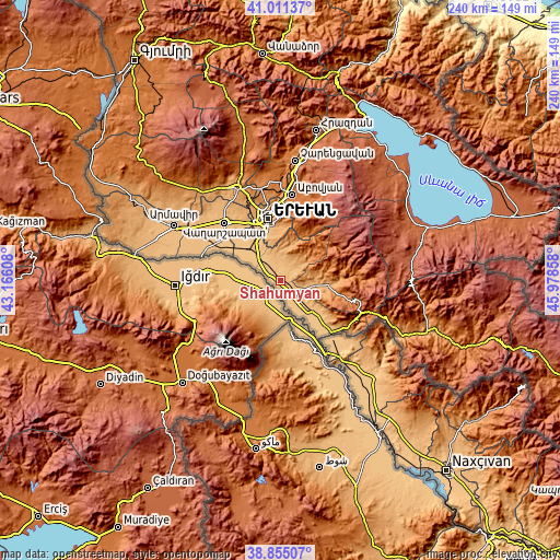
| \ | Map #1 | Map #2 | Topo.Map |
| Scale [m] | 811..914 m | 802..1382 m | × |
| Scale [ft] | 2661..2999 ft | 2631..4534 ft | × |
| Average | 837 m = 2746 ft | 861.6 m = 2827 ft | × |
| Width | 7.49 km = 4.7 mi | 14.99 km = 9.3 mi | 239.8 km = 149 mi |
| Height | 7.49 km = 4.7 mi | 14.99 km = 9.3 mi | 239.8 km = 149 mi |
| ↑Max Latitude | 39.975394° | 40.009062° | 41.01137° |
| Latitude at center | 39.94171° | 39.94171° | 39.94171° |
| ↓Min Latitude | 39.908009° | 39.874291° | 38.85507° |
| ← Min Longitude | 44.528385° | 44.484439° | 43.16608° |
| Longitude center | 44.57233° | 44.57233° | 44.57233° |
| →Max Longitude | 44.616275° | 44.660221° | 45.97858° |
Nearby cities:
Cities around Shahumyan sort by population:
• Artashat elevation 830 m
3.2 km,  312°
312°
• Verin Artashat 893 m
6.3 km,  12°
12°
• Aygezard 877 m
2.9 km,  61°
61°
• Norashen 906 m
6.9 km, 14°
• Vostan 837 m
2.8 km,  337°
337°
• Lusarrat 821 m
7.6 km,  170°
170°
• Dalar 839 m
5.5 km, 314°
• Aygestan 869 m
6.9 km,  350°
350°
• Aralez 856 m
8.5 km,  123°
123°
• Mrgavan 840 m
4.6 km,  317°
317°
• Berk’anush 836 m
6.2 km, 310°
• Aygepat 880 m
3 km,  51°
51°
Multilingual:
 En español:
Shahumyan elevación 832 m.
 En France:
Shahumyan élévation 832 m.
 Auf Deutsch:
Shahumyan höhe über dem Meeresspiegel ist 832 m.

Sources and notes:
- [note 1] Map square and city borders are not equal. Map elevation data is calculated only from area inside that square.
- [src 1] Elevation data from geonames database provided with same terms of usage.
- [src 2] The elevation map of Shahumyan is generated using elevation data from NASA's 3 arcsec (90m) resolution SRTM data.
- [src 3] Base (background) map © OpenStreetMap contributors tiles are generated by Geofabrik and OpenTopoMap.
Copyright & License:
This Shahumyan Elevation Map is licensed under CC BY-SA. You may reuse any part from this page, if you give a proper credit by linking to this URL:
 More info on terms of use page.