Funarë elevation
Funarë (Elbasan, Rrethi i Elbasanit), Albania elevation is 729 meters and Funarë elevation in feet is 2392 ft above sea level [src 1]. Funarë is a seat of a third-order administrative division (feature code) with elevation that is 355 meters (1165 ft) bigger than average city elevation in Albania.
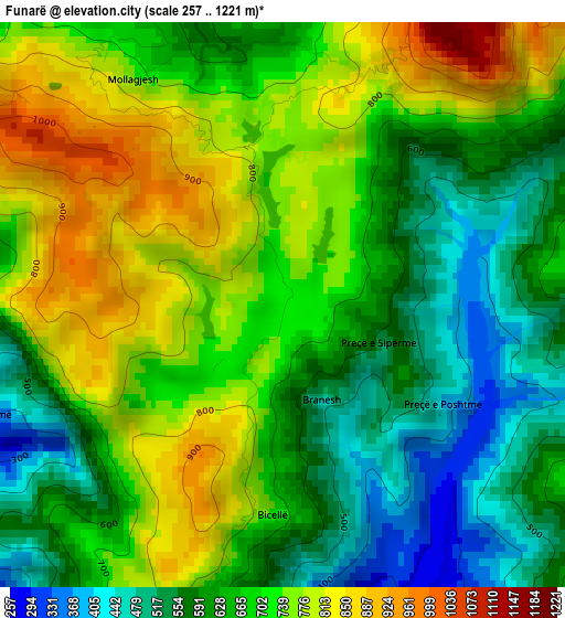
Below is the Elevation map of Funarë, which displays elevation range with different colors. Scale of the first map is from 257 to 1221 m (843 to 4006 ft) with average elevation of 675.1 meters (=2215 ft) [note 1]
These maps also provides idea of topography and contour of this city, they are displayed at different zoom levels. More info about maps, scale and edge coordinates you can find below images.
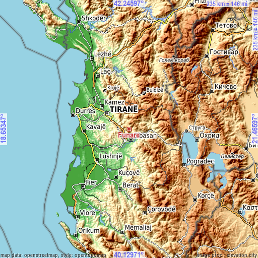
| \ | Map #1 | Topo.Map |
| Scale [m] | 257..1221 m | × |
| Scale [ft] | 843..4006 ft | × |
| Average | 675.1 m = 2215 ft | × |
| Width | 7.35 km = 4.6 mi | 235.3 km = 146.2 mi |
| Height | 7.35 km = 4.6 mi | 235.3 km = 146.2 mi |
| ↑Max Latitude | 41.229449° | 42.24597° |
| Latitude at center | 41.19639° | 41.19639° |
| ↓Min Latitude | 41.163315° | 40.12971° |
| ← Min Longitude | 20.015775° | 18.65347° |
| Longitude center | 20.05972° | 20.05972° |
| →Max Longitude | 20.103665° | 21.46597° |
Nearby cities:
Cities around Funarë sort by population:
• Elbasan elevation 128 m
9.5 km,  168°
168°
• Krrabë 416 m
7.7 km,  286°
286°
• Gjergjan 134 m
17.2 km,  188°
188°
• Shirgjan 124 m
16.1 km,  181°
181°
• Gostimë 309 m
16.1 km,  110°
110°
• Orenjë 802 m
16.1 km,  52°
52°
• Bërzhitë 216 m
14.3 km, 292°
• Shushicë 199 m
13.3 km,  145°
145°
• Bradashesh 112 m
10.6 km,  197°
197°
• Labinot-Fushë 165 m
9.5 km,  130°
130°
• Gracen 763 m
9.4 km,  238°
238°
• Labinot-Mal 823 m
7.8 km,  86°
86°
Multilingual:
 En español:
Funarë elevación 729 m.
 En France:
Funarë élévation 729 m.


Sources and notes:
- [note 1] Map square and city borders are not equal. Map elevation data is calculated only from area inside that square.
- [src 1] Elevation data from geonames database provided with same terms of usage.
- [src 2] The elevation map of Funarë is generated using elevation data from NASA's 3 arcsec (90m) resolution SRTM data.
- [src 3] Base (background) map © OpenStreetMap contributors tiles are generated by Geofabrik and OpenTopoMap.
Copyright & License:
This Funarë Elevation Map is licensed under CC BY-SA. You may reuse any part from this page, if you give a proper credit by linking to this URL:
 More info on terms of use page.