Cerava elevation
Cerava (Korçë, Rrethi i Pogradecit), Albania elevation is 805 meters and Cerava elevation in feet is 2641 ft above sea level [src 1]. Cerava is a seat of a third-order administrative division (feature code) with elevation that is 431 meters (1414 ft) bigger than average city elevation in Albania.
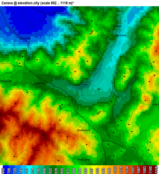
Below is the Elevation map of Cerava, which displays elevation range with different colors. Scale of the first map is from 692 to 1116 m (2270 to 3661 ft) with average elevation of 873.5 meters (=2866 ft) [note 1]
These maps also provides idea of topography and contour of this city, they are displayed at different zoom levels. More info about maps, scale and edge coordinates you can find below images.
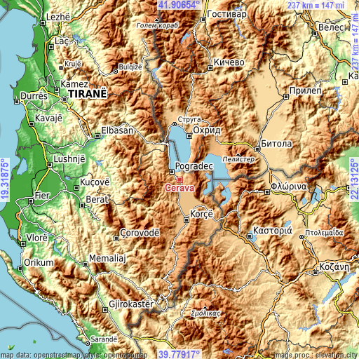
| \ | Map #1 | Topo.Map |
| Scale [m] | 692..1116 m | × |
| Scale [ft] | 2270..3661 ft | × |
| Average | 873.5 m = 2866 ft | × |
| Width | 7.39 km = 4.6 mi | 236.5 km = 147 mi |
| Height | 7.39 km = 4.6 mi | 236.5 km = 147 mi |
| ↑Max Latitude | 40.884622° | 41.90654° |
| Latitude at center | 40.85139° | 40.85139° |
| ↓Min Latitude | 40.818141° | 39.77917° |
| ← Min Longitude | 20.681055° | 19.31875° |
| Longitude center | 20.725° | 20.725° |
| →Max Longitude | 20.768945° | 22.13125° |
Nearby cities:
Cities around Cerava sort by population:
• Pogradec elevation 702 m
8.3 km,  312°
312°
• Maliq 844 m
16.3 km,  187°
187°
• Pojan 823 m
16.9 km,  145°
145°
• Liqenas 861 m
16.6 km,  115°
115°
• Libonik 832 m
16.4 km,  184°
184°
• Trebinjë 898 m
16 km,  295°
295°
• Udënisht 743 m
14.4 km,  329°
329°
• Novoselë 936 m
10.3 km, 192°
• Pirg 871 m
7.6 km, 192°
• Vreshtas 818 m
7.5 km,  144°
144°
• Buçimas 703 m
5.8 km,  320°
320°
• Dardhas 967 m
5.7 km,  263°
263°
Multilingual:
 En español:
Cerava elevación 805 m.
 En France:
Cerava élévation 805 m.


Sources and notes:
- [note 1] Map square and city borders are not equal. Map elevation data is calculated only from area inside that square.
- [src 1] Elevation data from geonames database provided with same terms of usage.
- [src 2] The elevation map of Cerava is generated using elevation data from NASA's 3 arcsec (90m) resolution SRTM data.
- [src 3] Base (background) map © OpenStreetMap contributors tiles are generated by Geofabrik and OpenTopoMap.
Copyright & License:
This Cerava Elevation Map is licensed under CC BY-SA. You may reuse any part from this page, if you give a proper credit by linking to this URL:
 More info on terms of use page.