Çorovodë elevation
Çorovodë (Berat, Rrethi i Skraparit), Albania elevation is 320 meters and Çorovodë elevation in feet is 1050 ft above sea level [src 1]. Çorovodë is a seat of a second-order administrative division (feature code) with elevation that is 54 meters (177 ft) smaller than average city elevation in Albania.
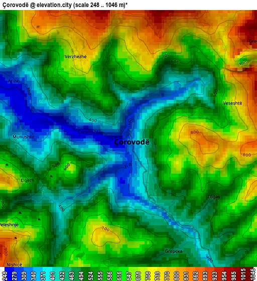
Below is the Elevation map of Çorovodë, which displays elevation range with different colors. Scale of the first map is from 248 to 1046 m (814 to 3432 ft) with average elevation of 567.2 meters (=1861 ft) [note 1]
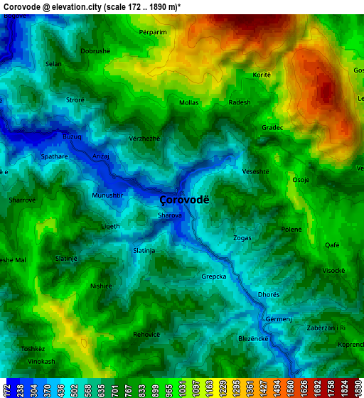
These maps also provides idea of topography and contour of this city, they are displayed at different zoom levels. More info about maps, scale and edge coordinates you can find below images.
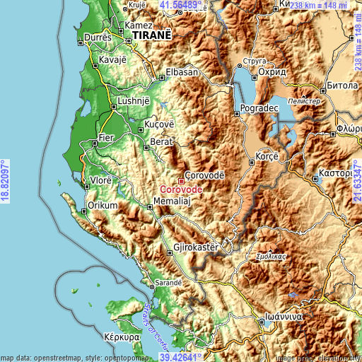
| \ | Map #1 | Map #2 | Topo.Map |
| Scale [m] | 248..1046 m | 172..1890 m | × |
| Scale [ft] | 814..3432 ft | 564..6201 ft | × |
| Average | 567.2 m = 1861 ft | 777.3 m = 2550 ft | × |
| Width | 7.43 km = 4.6 mi | 14.86 km = 9.2 mi | 237.8 km = 147.8 mi |
| Height | 7.43 km = 4.6 mi | 14.86 km = 9.2 mi | 237.8 km = 147.8 mi |
| ↑Max Latitude | 40.537576° | 40.570965° | 41.56489° |
| Latitude at center | 40.50417° | 40.50417° | 40.50417° |
| ↓Min Latitude | 40.470747° | 40.437308° | 39.42641° |
| ← Min Longitude | 20.183275° | 20.139329° | 18.82097° |
| Longitude center | 20.22722° | 20.22722° | 20.22722° |
| →Max Longitude | 20.271165° | 20.315111° | 21.63347° |
Nearby cities:
Cities around Çorovodë sort by population:
• Poliçan elevation 328 m
16.2 km,  317°
317°
• Zhepë 801 m
20 km,  14°
14°
• Buz 747 m
19.9 km,  250°
250°
• Sukë 259 m
15.6 km,  203°
203°
• Topojan 648 m
14.2 km,  184°
184°
• Gjerbës 821 m
14 km, 8°
• Ballaban 322 m
12.5 km,  218°
218°
• Potom 980 m
12.5 km,  98°
98°
• Bogovë 197 m
9.9 km, 318°
• Çepan 817 m
9.7 km,  163°
163°
• Leshnjë 1098 m
8.1 km,  63°
63°
• Vendresha e Vogël 679 m
7.8 km,  272°
272°
Multilingual:
 En español:
Çorovodë elevación 320 m.
 En France:
Çorovodë élévation 320 m.
 Auf Deutsch:
Çorovodë höhe über dem Meeresspiegel ist 320 m.

Sources and notes:
- [note 1] Map square and city borders are not equal. Map elevation data is calculated only from area inside that square.
- [src 1] Elevation data from geonames database provided with same terms of usage.
- [src 2] The elevation map of Çorovodë is generated using elevation data from NASA's 3 arcsec (90m) resolution SRTM data.
- [src 3] Base (background) map © OpenStreetMap contributors tiles are generated by Geofabrik and OpenTopoMap.
Copyright & License:
This Çorovodë Elevation Map is licensed under CC BY-SA. You may reuse any part from this page, if you give a proper credit by linking to this URL:
 More info on terms of use page.