Kukës elevation
Kukës, Albania elevation is 351 meters and Kukës elevation in feet is 1152 ft above sea level [src 1]. Kukës is a seat of a first-order administrative division (feature code) with elevation that is 23 meters (75 ft) smaller than average city elevation in Albania.
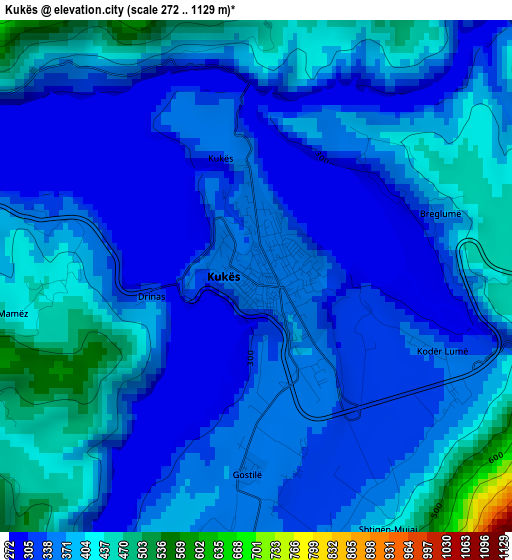
Below is the Elevation map of Kukës, which displays elevation range with different colors. Scale of the first map is from 272 to 1129 m (892 to 3704 ft) with average elevation of 364.4 meters (=1196 ft) [note 1]
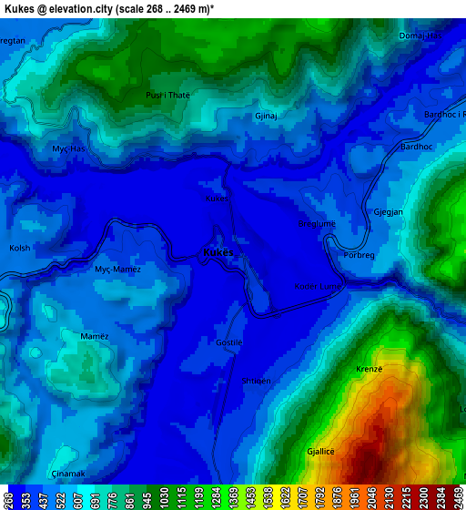
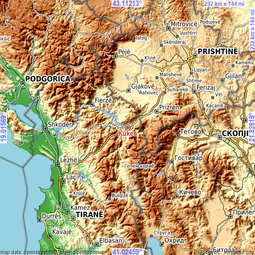
These maps also provides idea of topography and contour of this city, they are displayed at different zoom levels. More info about maps, scale and edge coordinates you can find below images.
| \ | Map #1 | Map #2 | Topo.Map |
| Scale [m] | 272..1129 m | 268..2469 m | × |
| Scale [ft] | 892..3704 ft | 879..8100 ft | × |
| Average | 364.4 m = 1196 ft | 643 m = 2110 ft | × |
| Width | 7.25 km = 4.5 mi | 14.51 km = 9 mi | 232.1 km = 144.2 mi |
| Height | 7.25 km = 4.5 mi | 14.51 km = 9 mi | 232.1 km = 144.2 mi |
| ↑Max Latitude | 42.10955° | 42.142143° | 43.11213° |
| Latitude at center | 42.07694° | 42.07694° | 42.07694° |
| ↓Min Latitude | 42.044313° | 42.01167° | 41.02459° |
| ← Min Longitude | 20.377995° | 20.334049° | 19.01569° |
| Longitude center | 20.42194° | 20.42194° | 20.42194° |
| →Max Longitude | 20.465885° | 20.509831° | 21.82819° |
Nearby cities:
Cities around Kukës sort by population:
• Ujmisht elevation 594 m
19.7 km,  198°
198°
• Golaj 496 m
19.3 km,  349°
349°
• Shishtavec 1352 m
18.6 km,  125°
125°
• Shënmëri 409 m
15.4 km,  281°
281°
• Krumë 462 m
13.4 km,  356°
356°
• Fajzë 428 m
11.6 km,  329°
329°
• Surroj 595 m
11.4 km,  214°
214°
• Zapod 1198 m
11.2 km,  105°
105°
• Bicaj 464 m
9.2 km,  184°
184°
• Kolsh 499 m
6.6 km,  271°
271°
• Gjinaj 705 m
4.7 km,  14°
14°
• Shtiqën 364 m
4.2 km,  165°
165°
Multilingual:
 En español:
Kukës elevación 351 m.
 En France:
Kukës élévation 351 m.


Sources and notes:
- [note 1] Map square and city borders are not equal. Map elevation data is calculated only from area inside that square.
- [src 1] Elevation data from geonames database provided with same terms of usage.
- [src 2] The elevation map of Kukës is generated using elevation data from NASA's 3 arcsec (90m) resolution SRTM data.
- [src 3] Base (background) map © OpenStreetMap contributors tiles are generated by Geofabrik and OpenTopoMap.
Copyright & License:
This Kukës Elevation Map is licensed under CC BY-SA. You may reuse any part from this page, if you give a proper credit by linking to this URL:
 More info on terms of use page.