Mborje elevation
Mborje (Korçë), Albania elevation is 977 meters and Mborje elevation in feet is 3205 ft above sea level [src 1]. Mborje is a populated place (feature code) with elevation that is 603 meters (1978 ft) bigger than average city elevation in Albania.
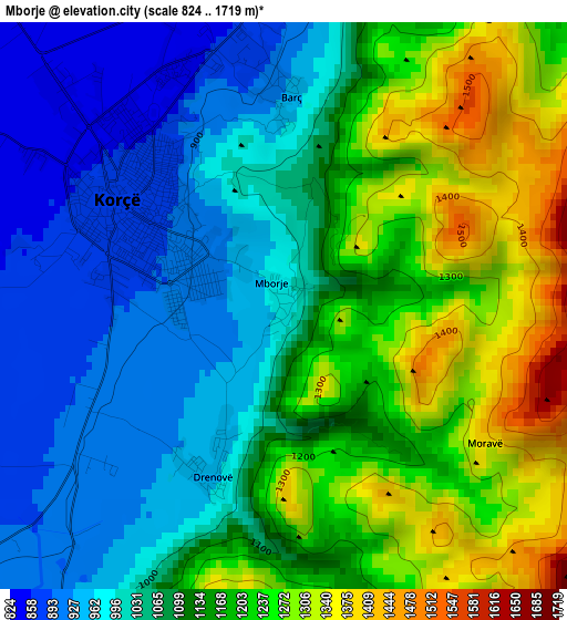
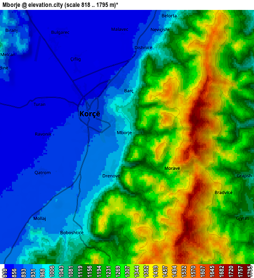
Below is the Elevation map of Mborje, which displays elevation range with different colors. Scale of the first map is from 824 to 1719 m (2703 to 5640 ft) with average elevation of 1109.6 meters (=3640 ft) [note 1]
These maps also provides idea of topography and contour of this city, they are displayed at different zoom levels. More info about maps, scale and edge coordinates you can find below images.
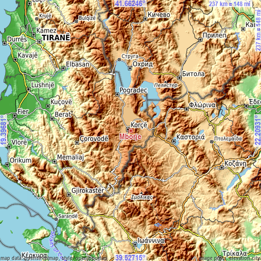
| \ | Map #1 | Map #2 | Topo.Map |
| Scale [m] | 824..1719 m | 818..1795 m | × |
| Scale [ft] | 2703..5640 ft | 2684..5889 ft | × |
| Average | 1109.6 m = 3640 ft | 1109 m = 3638 ft | × |
| Width | 7.42 km = 4.6 mi | 14.84 km = 9.2 mi | 237.4 km = 147.5 mi |
| Height | 7.42 km = 4.6 mi | 14.84 km = 9.2 mi | 237.4 km = 147.5 mi |
| ↑Max Latitude | 40.636686° | 40.670026° | 41.66246° |
| Latitude at center | 40.60333° | 40.60333° | 40.60333° |
| ↓Min Latitude | 40.569957° | 40.536567° | 39.52715° |
| ← Min Longitude | 20.759115° | 20.715169° | 19.39681° |
| Longitude center | 20.80306° | 20.80306° | 20.80306° |
| →Max Longitude | 20.847005° | 20.890951° | 22.20931° |
Nearby cities:
Cities around Mborje sort by population:
• Korçë elevation 869 m
2.5 km,  312°
312°
• Bilisht 926 m
16 km,  80°
80°
• Maliq 844 m
14.3 km,  322°
322°
• Progër 842 m
15.4 km,  48°
48°
• Miras 967 m
14.9 km,  134°
134°
• Pojan 823 m
13.9 km,  12°
12°
• Libonik 832 m
13.8 km, 324°
• Voskop 893 m
9.6 km,  275°
275°
• Hoçisht 919 m
9.4 km,  86°
86°
• Mollaj 893 m
7.1 km,  227°
227°
• Dishnicë 877 m
5.4 km, 9°
• Drenovë 954 m
2.4 km,  202°
202°
Multilingual:
 En español:
Mborje elevación 977 m.
 En France:
Mborje élévation 977 m.


Sources and notes:
- [note 1] Map square and city borders are not equal. Map elevation data is calculated only from area inside that square.
- [src 1] Elevation data from geonames database provided with same terms of usage.
- [src 2] The elevation map of Mborje is generated using elevation data from NASA's 3 arcsec (90m) resolution SRTM data.
- [src 3] Base (background) map © OpenStreetMap contributors tiles are generated by Geofabrik and OpenTopoMap.
Copyright & License:
This Mborje Elevation Map is licensed under CC BY-SA. You may reuse any part from this page, if you give a proper credit by linking to this URL:
 More info on terms of use page.