Sarandë elevation
Sarandë (Vlorë, Rrethi i Sarandës), Albania elevation is 170 meters and Sarandë elevation in feet is 558 ft above sea level [src 1]. Sarandë is a seat of a second-order administrative division (feature code) with elevation that is 204 meters (669 ft) smaller than average city elevation in Albania.
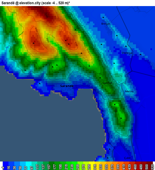
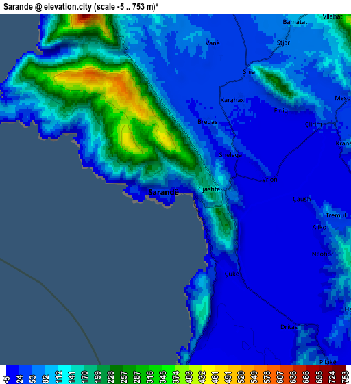
Below is the Elevation map of Sarandë, which displays elevation range with different colors. Scale of the first map is from -4 to 520 m (-13 to 1706 ft) with average elevation of 125.7 meters (=412 ft) [note 1]
These maps also provides idea of topography and contour of this city, they are displayed at different zoom levels. More info about maps, scale and edge coordinates you can find below images.
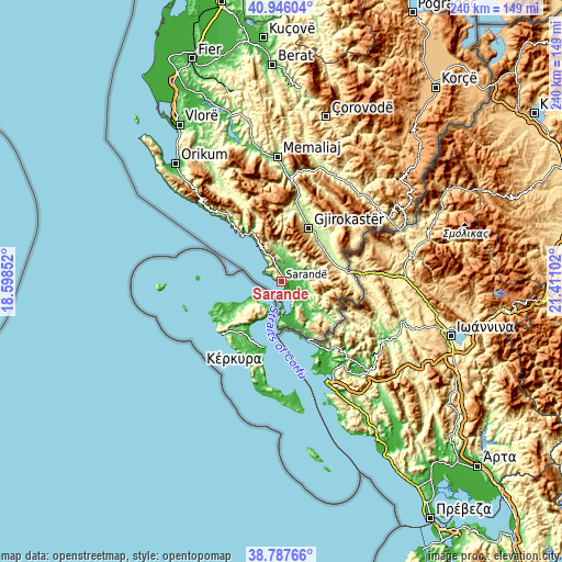
| \ | Map #1 | Map #2 | Topo.Map |
| Scale [m] | -4..520 m | -5..753 m | × |
| Scale [ft] | -13..1706 ft | -16..2470 ft | × |
| Average | 125.7 m = 412 ft | 90.4 m = 297 ft | × |
| Width | 7.5 km = 4.7 mi | 15 km = 9.3 mi | 240 km = 149.1 mi |
| Height | 7.5 km = 4.7 mi | 15 km = 9.3 mi | 240 km = 149.1 mi |
| ↑Max Latitude | 39.909057° | 39.942758° | 40.94604° |
| Latitude at center | 39.87534° | 39.87534° | 39.87534° |
| ↓Min Latitude | 39.841606° | 39.807856° | 38.78766° |
| ← Min Longitude | 19.960825° | 19.916879° | 18.59852° |
| Longitude center | 20.00477° | 20.00477° | 20.00477° |
| →Max Longitude | 20.048715° | 20.092661° | 21.41102° |
Nearby cities:
Cities around Sarandë sort by population:
• Delvinë elevation 200 m
11.6 km,  43°
43°
• Ksamil 16 m
11.8 km,  182°
182°
• Markat 472 m
22.7 km,  134°
134°
• Lazarat 457 m
22.6 km,  32°
32°
• Xarrë 8 m
16.9 km,  165°
165°
• Lukovë 229 m
15.1 km,  329°
329°
• Dhivër 382 m
14.6 km,  107°
107°
• Vergo 234 m
14.6 km,  1°
1°
• Livadhja 35 m
13.9 km, 133°
• Mesopotam 47 m
8.4 km,  62°
62°
• Aliko 33 m
6.6 km, 106°
• Finiq 37 m
5.7 km,  52°
52°
Multilingual:
 En español:
Sarandë elevación 170 m.
 En France:
Sarandë élévation 170 m.


Sources and notes:
- [note 1] Map square and city borders are not equal. Map elevation data is calculated only from area inside that square.
- [src 1] Elevation data from geonames database provided with same terms of usage.
- [src 2] The elevation map of Sarandë is generated using elevation data from NASA's 3 arcsec (90m) resolution SRTM data.
- [src 3] Base (background) map © OpenStreetMap contributors tiles are generated by Geofabrik and OpenTopoMap.
Copyright & License:
This Sarandë Elevation Map is licensed under CC BY-SA. You may reuse any part from this page, if you give a proper credit by linking to this URL:
 More info on terms of use page.