Lushnjë elevation
Lushnjë (Fier, Rrethi i Lushnjës), Albania elevation is 22 meters and Lushnjë elevation in feet is 72 ft above sea level [src 1]. Lushnjë is a seat of a second-order administrative division (feature code) with elevation that is 352 meters (1155 ft) smaller than average city elevation in Albania.
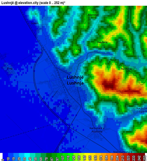
Below is the Elevation map of Lushnjë, which displays elevation range with different colors. Scale of the first map is from 0 to 252 m (0 to 827 ft) with average elevation of 47.4 meters (=156 ft) [note 1]
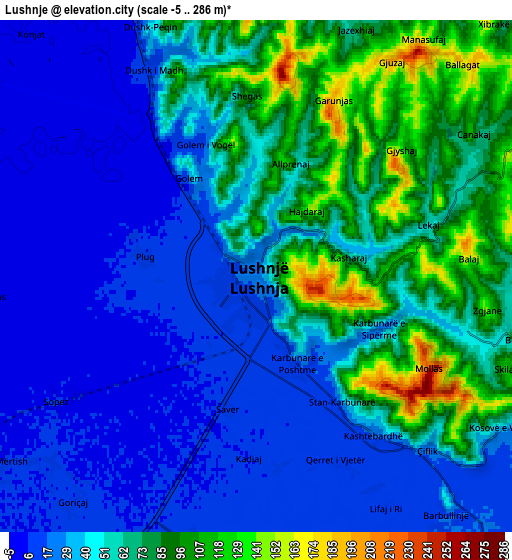
These maps also provides idea of topography and contour of this city, they are displayed at different zoom levels. More info about maps, scale and edge coordinates you can find below images.
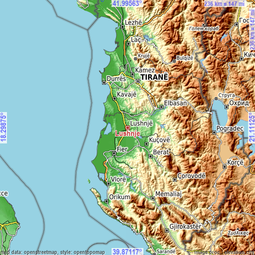
| \ | Map #1 | Map #2 | Topo.Map |
| Scale [m] | 0..252 m | -5..286 m | × |
| Scale [ft] | 0..827 ft | -16..938 ft | × |
| Average | 47.4 m = 156 ft | 49.6 m = 163 ft | × |
| Width | 7.38 km = 4.6 mi | 14.76 km = 9.2 mi | 236.2 km = 146.8 mi |
| Height | 7.38 km = 4.6 mi | 14.76 km = 9.2 mi | 236.2 km = 146.8 mi |
| ↑Max Latitude | 40.975127° | 41.008297° | 41.99563° |
| Latitude at center | 40.94194° | 40.94194° | 40.94194° |
| ↓Min Latitude | 40.908737° | 40.875516° | 39.87117° |
| ← Min Longitude | 19.661055° | 19.617109° | 18.29875° |
| Longitude center | 19.705° | 19.705° | 19.705° |
| →Max Longitude | 19.748945° | 19.792891° | 21.11125° |
Nearby cities:
Cities around Lushnjë sort by population:
• Peqin elevation 52 m
12.2 km,  18°
18°
• Gradishtë 8 m
11.7 km,  239°
239°
• Fier-Shegan 19 m
10.7 km,  140°
140°
• Grabjan 26 m
10.5 km,  276°
276°
• Allkaj 15 m
10.3 km,  155°
155°
• Rrasa e Sipërme 153 m
10.2 km,  73°
73°
• Gjoçaj 33 m
9.4 km,  9°
9°
• Krutja e Poshtme 10 m
8 km,  194°
194°
• Hysgjokaj 142 m
7.8 km, 65°
• Ballagat 179 m
7.8 km,  40°
40°
• Golem 32 m
3.3 km,  330°
330°
• Karbunara e Vogël 20 m
2.5 km,  154°
154°
Multilingual:
 En español:
Lushnjë elevación 22 m.
 En France:
Lushnjë élévation 22 m.


Sources and notes:
- [note 1] Map square and city borders are not equal. Map elevation data is calculated only from area inside that square.
- [src 1] Elevation data from geonames database provided with same terms of usage.
- [src 2] The elevation map of Lushnjë is generated using elevation data from NASA's 3 arcsec (90m) resolution SRTM data.
- [src 3] Base (background) map © OpenStreetMap contributors tiles are generated by Geofabrik and OpenTopoMap.
Copyright & License:
This Lushnjë Elevation Map is licensed under CC BY-SA. You may reuse any part from this page, if you give a proper credit by linking to this URL:
 More info on terms of use page.