Cascade elevation
Cascade, Seychelles elevation is 4 meters and Cascade elevation in feet is 13 ft above sea level [src 1]. Cascade is a seat of a first-order administrative division (feature code) with elevation that is 54 meters (177 ft) smaller than average city elevation in Seychelles.
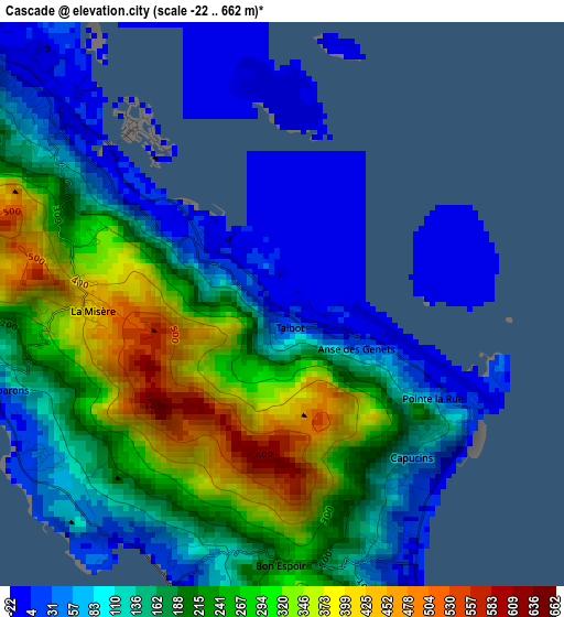
Below is the Elevation map of Cascade, which displays elevation range with different colors. Scale of the first map is from -22 to 662 m (-72 to 2172 ft) with average elevation of 179 meters (=587 ft) [note 1]
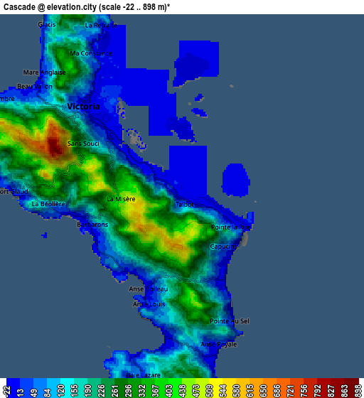
These maps also provides idea of topography and contour of this city, they are displayed at different zoom levels. More info about maps, scale and edge coordinates you can find below images.
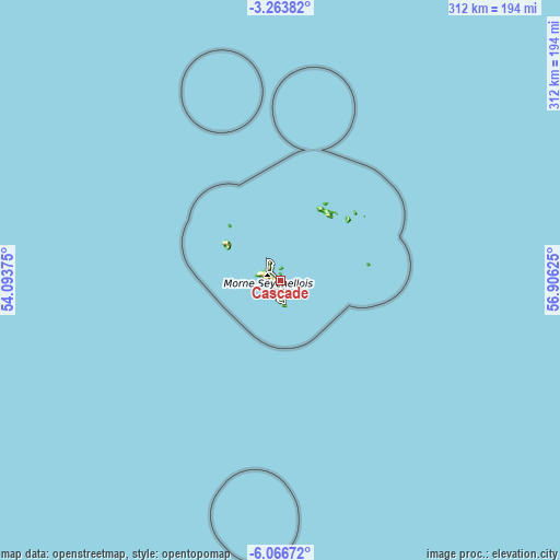
| \ | Map #1 | Map #2 | Topo.Map |
| Scale [m] | -22..662 m | -22..898 m | × |
| Scale [ft] | -72..2172 ft | -72..2946 ft | × |
| Average | 179 m = 587 ft | 173.6 m = 570 ft | × |
| Width | 9.74 km = 6.1 mi | 19.48 km = 12.1 mi | 311.7 km = 193.7 mi |
| Height | 9.74 km = 6.1 mi | 19.48 km = 12.1 mi | 311.7 km = 193.7 mi |
| ↑Max Latitude | -4.622869° | -4.579065° | -3.26382° |
| Latitude at center | -4.66667° | -4.66667° | -4.66667° |
| ↓Min Latitude | -4.710468° | -4.754264° | -6.06672° |
| ← Min Longitude | 55.456055° | 55.412109° | 54.09375° |
| Longitude center | 55.5° | 55.5° | 55.5° |
| →Max Longitude | 55.543945° | 55.587891° | 56.90625° |
Nearby cities:
Cities around Cascade sort by population:
• Victoria elevation 6 m
7.2 km,  316°
316°
• Anse Boileau 3 m
5.9 km,  198°
198°
• Bel Ombre 16 m
10.8 km,  301°
301°
• Beau Vallon 76 m
9.3 km, 303°
• Anse Royale 106 m
7.6 km,  166°
166°
• Takamaka 272 m
11.1 km,  180°
180°
• Port Glaud 25 m
9.2 km,  270°
270°
• La Passe 10 m
51.1 km,  46°
46°
Multilingual:
 En español:
Cascade elevación 4 m.
 En France:
Cascade élévation 4 m.


Sources and notes:
- [note 1] Map square and city borders are not equal. Map elevation data is calculated only from area inside that square.
- [src 1] Elevation data from geonames database provided with same terms of usage.
- [src 2] The elevation map of Cascade is generated using elevation data from NASA's 3 arcsec (90m) resolution SRTM data.
- [src 3] Base (background) map © OpenStreetMap contributors tiles are generated by Geofabrik and OpenTopoMap.
Copyright & License:
This Cascade Elevation Map is licensed under CC BY-SA. You may reuse any part from this page, if you give a proper credit by linking to this URL:
 More info on terms of use page.