Rochester elevation
Rochester (New York, Monroe County), United States elevation is 156 meters and Rochester elevation in feet is 512 ft above sea level [src 1]. Rochester is a seat of a second-order administrative division (feature code) with elevation that is 123 meters (404 ft) smaller than average city elevation in United States.
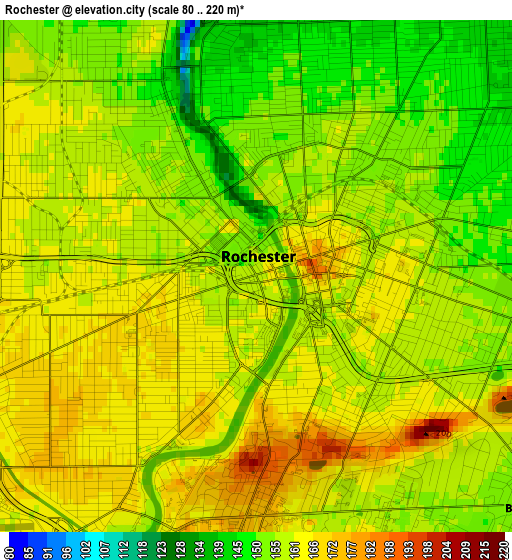
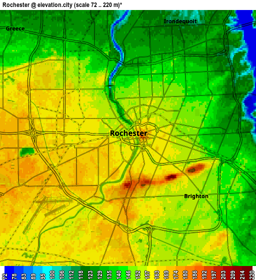
Below is the Elevation map of Rochester, which displays elevation range with different colors. Scale of the first map is from 80 to 220 m (262 to 722 ft) with average elevation of 158.9 meters (=521 ft) [note 1]
These maps also provides idea of topography and contour of this city, they are displayed at different zoom levels. More info about maps, scale and edge coordinates you can find below images.
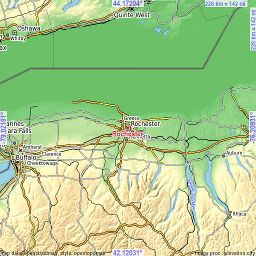
| \ | Map #1 | Map #2 | Topo.Map |
| Scale [m] | 80..220 m | 72..220 m | × |
| Scale [ft] | 262..722 ft | 236..722 ft | × |
| Average | 158.9 m = 521 ft | 148.5 m = 487 ft | × |
| Width | 7.13 km = 4.4 mi | 14.26 km = 8.9 mi | 228.1 km = 141.7 mi |
| Height | 7.13 km = 4.4 mi | 14.26 km = 8.9 mi | 228.1 km = 141.7 mi |
| ↑Max Latitude | 43.18683° | 43.218863° | 44.17204° |
| Latitude at center | 43.15478° | 43.15478° | 43.15478° |
| ↓Min Latitude | 43.122713° | 43.090629° | 42.12031° |
| ← Min Longitude | -77.659505° | -77.703451° | -79.02181° |
| Longitude center | -77.61556° | -77.61556° | -77.61556° |
| →Max Longitude | -77.571615° | -77.527669° | -76.20931° |
Nearby cities:
Cities around Rochester sort by population:
• Irondequoit elevation 117 m
7.1 km,  24°
24°
• Brighton 137 m
5.3 km,  98°
98°
• Gates-North Gates 170 m
7 km,  279°
279°
• Greece 134 m
8.8 km,  314°
314°
• North Gates 163 m
7.4 km,  289°
289°
• East Rochester 138 m
11.6 km,  116°
116°
• Hilton 87 m
20.7 km,  315°
315°
• Webster 134 m
16.3 km,  66°
66°
• Fairport 152 m
15.4 km,  113°
113°
• Spencerport 172 m
15.7 km, 282°
• Scottsville 190 m
17.8 km,  216°
216°
• Pittsford 150 m
10.8 km,  131°
131°
Multilingual:
 En español:
Rochester elevación 156 m.
 En France:
Rochester élévation 156 m.
 Auf Deutsch:
Rochester höhe über dem Meeresspiegel ist 156 m.

Sources and notes:
- [note 1] Map square and city borders are not equal. Map elevation data is calculated only from area inside that square.
- [src 1] Elevation data from geonames database provided with same terms of usage.
- [src 2] The elevation map of Rochester is generated using elevation data from NASA's 3 arcsec (90m) resolution SRTM data.
- [src 3] Base (background) map © OpenStreetMap contributors tiles are generated by Geofabrik and OpenTopoMap.
Copyright & License:
This Rochester Elevation Map is licensed under CC BY-SA. You may reuse any part from this page, if you give a proper credit by linking to this URL:
 More info on terms of use page.