Strogino elevation
Strogino (Moscow), Russia elevation is 125 meters and Strogino elevation in feet is 410 ft above sea level [src 1]. Strogino is a section of populated place (feature code) with elevation that is 74 meters (243 ft) smaller than average city elevation in Russia.
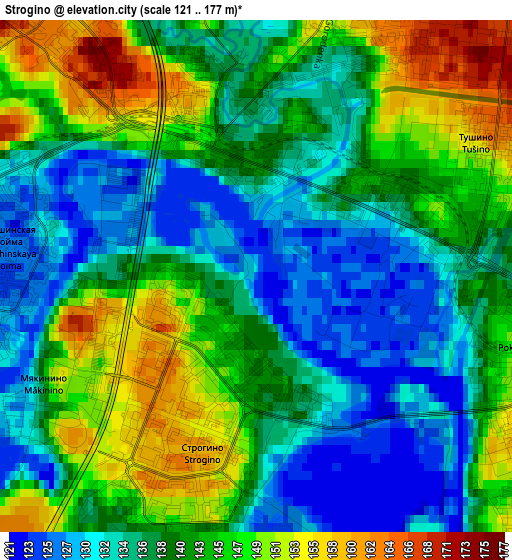
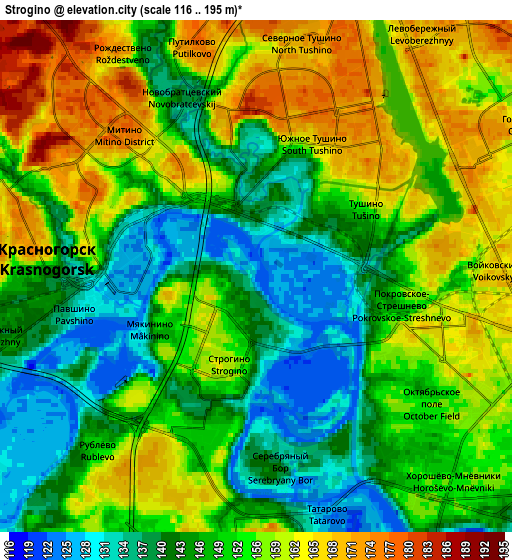
Below is the Elevation map of Strogino, which displays elevation range with different colors. Scale of the first map is from 121 to 177 m (397 to 581 ft) with average elevation of 140.3 meters (=460 ft) [note 1]
These maps also provides idea of topography and contour of this city, they are displayed at different zoom levels. More info about maps, scale and edge coordinates you can find below images.
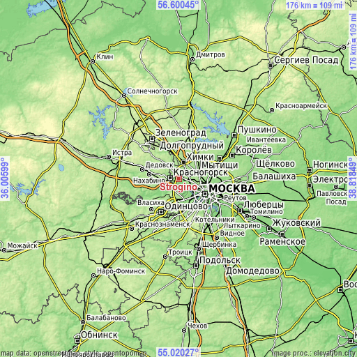
| \ | Map #1 | Map #2 | Topo.Map |
| Scale [m] | 121..177 m | 116..195 m | × |
| Scale [ft] | 397..581 ft | 381..640 ft | × |
| Average | 140.3 m = 460 ft | 151.5 m = 497 ft | × |
| Width | 5.49 km = 3.4 mi | 10.98 km = 6.8 mi | 175.7 km = 109.2 mi |
| Height | 5.49 km = 3.4 mi | 10.98 km = 6.8 mi | 175.7 km = 109.2 mi |
| ↑Max Latitude | 55.843061° | 55.867727° | 56.60045° |
| Latitude at center | 55.81838° | 55.81838° | 55.81838° |
| ↓Min Latitude | 55.793683° | 55.76897° | 55.02027° |
| ← Min Longitude | 37.368295° | 37.324349° | 36.00599° |
| Longitude center | 37.41224° | 37.41224° | 37.41224° |
| →Max Longitude | 37.456185° | 37.500131° | 38.81849° |
Nearby cities:
Cities around Strogino sort by population:
• Khoroshëvo-Mnevniki elevation 148 m
5.3 km,  136°
136°
• Shchukino 153 m
3.1 km,  130°
130°
• Krasnogorsk 155 m
5.1 km,  272°
272°
• Sokol 159 m
6.8 km,  107°
107°
• Pokrovskoye-Streshnëvo 157 m
3.1 km, 111°
• Levoberezhnyy 168 m
5.7 km,  51°
51°
• Novokhovrino 171 m
7.7 km, 45°
• Rublëvo 151 m
5.2 km,  224°
224°
• Golovinskiy 155 m
6.5 km, 53°
• Koptëvo 166 m
6.5 km,  91°
91°
• Arkhangel’skoye 159 m
7.8 km,  244°
244°
• Pavshino 137 m
3.9 km, 267°
Multilingual:
 En español:
Strogino elevación 125 m.
 En France:
Strogino élévation 125 m.
 Auf Deutsch:
Strogino höhe über dem Meeresspiegel ist 125 m.

Sources and notes:
- [note 1] Map square and city borders are not equal. Map elevation data is calculated only from area inside that square.
- [src 1] Elevation data from geonames database provided with same terms of usage.
- [src 2] The elevation map of Strogino is generated using elevation data from NASA's 3 arcsec (90m) resolution SRTM data.
- [src 3] Base (background) map © OpenStreetMap contributors tiles are generated by Geofabrik and OpenTopoMap.
Copyright & License:
This Strogino Elevation Map is licensed under CC BY-SA. You may reuse any part from this page, if you give a proper credit by linking to this URL:
 More info on terms of use page.