Nextipac elevation
Nextipac (Jalisco, Zapopan), Mexico elevation is 1657 meters and Nextipac elevation in feet is 5436 ft above sea level [src 1]. Nextipac is a populated place (feature code) with elevation that is 343 meters (1125 ft) bigger than average city elevation in Mexico.
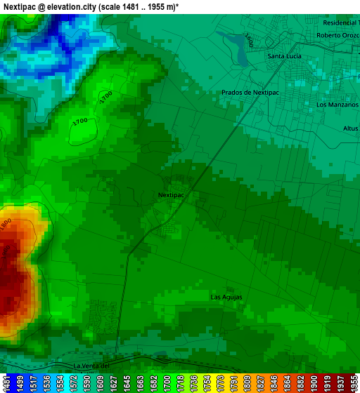
Below is the Elevation map of Nextipac, which displays elevation range with different colors. Scale of the first map is from 1481 to 1955 m (4859 to 6414 ft) with average elevation of 1640.7 meters (=5383 ft) [note 1]
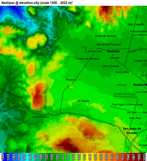
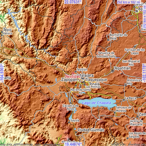
These maps also provides idea of topography and contour of this city, they are displayed at different zoom levels. More info about maps, scale and edge coordinates you can find below images.
| \ | Map #1 | Map #2 | Topo.Map |
| Scale [m] | 1481..1955 m | 1308..2022 m | × |
| Scale [ft] | 4859..6414 ft | 4291..6634 ft | × |
| Average | 1640.7 m = 5383 ft | 1634.7 m = 5363 ft | × |
| Width | 9.14 km = 5.7 mi | 18.28 km = 11.4 mi | 292.4 km = 181.7 mi |
| Height | 9.14 km = 5.7 mi | 18.28 km = 11.4 mi | 292.4 km = 181.7 mi |
| ↑Max Latitude | 20.808335° | 20.849408° | 22.07631° |
| Latitude at center | 20.76725° | 20.76725° | 20.76725° |
| ↓Min Latitude | 20.726154° | 20.685047° | 19.44674° |
| ← Min Longitude | -103.567995° | -103.611941° | -104.9303° |
| Longitude center | -103.52405° | -103.52405° | -103.52405° |
| →Max Longitude | -103.480105° | -103.436159° | -102.1178° |
Nearby cities:
Cities around Nextipac sort by population:
• Zapopan elevation 1568 m
15.3 km,  108°
108°
• Tesistán 1596 m
6.7 km,  56°
56°
• Nuevo México 1625 m
8.5 km,  98°
98°
• La Venta del Astillero 1626 m
4.9 km,  206°
206°
• Campestre las Palomas [Fraccionamiento] 1616 m
9.4 km,  53°
53°
• Zapopan2 1552 m
14.1 km, 113°
• Santa Cruz del Astillero 1437 m
12.6 km,  259°
259°
• La Primavera 1597 m
6.5 km,  221°
221°
• Huaxtla 1420 m
15 km,  254°
254°
• Campo Real 1600 m
8.7 km,  75°
75°
• La Cuchilla (Extramuros de Tesistán) 1608 m
6.6 km, 77°
• Puerta del Llano 1604 m
6.8 km,  72°
72°
Multilingual:
 En español:
Nextipac elevación 1657 m.
 En France:
Nextipac élévation 1657 m.
 Auf Deutsch:
Nextipac höhe über dem Meeresspiegel ist 1657 m.

Sources and notes:
- [note 1] Map square and city borders are not equal. Map elevation data is calculated only from area inside that square.
- [src 1] Elevation data from geonames database provided with same terms of usage.
- [src 2] The elevation map of Nextipac is generated using elevation data from NASA's 3 arcsec (90m) resolution SRTM data.
- [src 3] Base (background) map © OpenStreetMap contributors tiles are generated by Geofabrik and OpenTopoMap.
Copyright & License:
This Nextipac Elevation Map is licensed under CC BY-SA. You may reuse any part from this page, if you give a proper credit by linking to this URL:
 More info on terms of use page.