Tulancingo elevation
Tulancingo (Hidalgo, Tulancingo de Bravo), Mexico elevation is 2187 meters and Tulancingo elevation in feet is 7175 ft above sea level [src 1]. Tulancingo is a seat of a second-order administrative division (feature code) with elevation that is 873 meters (2864 ft) bigger than average city elevation in Mexico.
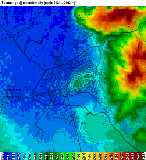
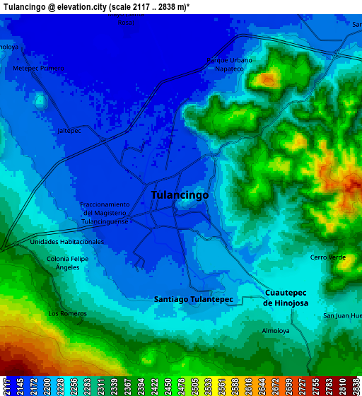
Below is the Elevation map of Tulancingo, which displays elevation range with different colors. Scale of the first map is from 2131 to 2493 m (6991 to 8179 ft) with average elevation of 2211.4 meters (=7255 ft) [note 1]
These maps also provides idea of topography and contour of this city, they are displayed at different zoom levels. More info about maps, scale and edge coordinates you can find below images.
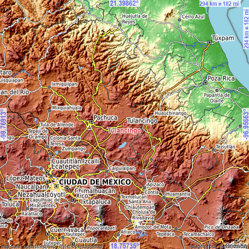
| \ | Map #1 | Map #2 | Topo.Map |
| Scale [m] | 2131..2493 m | 2117..2838 m | × |
| Scale [ft] | 6991..8179 ft | 6946..9311 ft | × |
| Average | 2211.4 m = 7255 ft | 2270.4 m = 7449 ft | × |
| Width | 9.18 km = 5.7 mi | 18.36 km = 11.4 mi | 293.7 km = 182.5 mi |
| Height | 9.18 km = 5.7 mi | 18.36 km = 11.4 mi | 293.7 km = 182.5 mi |
| ↑Max Latitude | 20.124818° | 20.166074° | 21.39862° |
| Latitude at center | 20.08355° | 20.08355° | 20.08355° |
| ↓Min Latitude | 20.042271° | 20.000982° | 18.75735° |
| ← Min Longitude | -98.406825° | -98.450771° | -99.76913° |
| Longitude center | -98.36288° | -98.36288° | -98.36288° |
| →Max Longitude | -98.318935° | -98.274989° | -96.95663° |
Nearby cities:
Cities around Tulancingo sort by population:
• Santiago Tulantepec elevation 2196 m
5.3 km,  171°
171°
• Jaltepec 2164 m
6.7 km,  302°
302°
• Javier Rojo Gómez 2208 m
5.9 km,  254°
254°
• Unidades Habitacionales 2228 m
6.4 km, 250°
• Rincones de la Hacienda 2148 m
5.7 km,  315°
315°
• Pedregal de San José 2179 m
5 km, 247°
• Colonia Felipe Ángeles 2258 m
6.7 km,  240°
240°
• Ahuehuetitla 2180 m
5.6 km,  271°
271°
• El Tepeyac 2270 m
6.6 km,  123°
123°
• Fraccionamiento del Magisterio Tulancinguense 2156 m
3.9 km,  258°
258°
• Ventoquipa 2219 m
6.1 km,  154°
154°
• San Nicolás el Chico 2151 m
2.9 km, 297°
Multilingual:
 En español:
Tulancingo de Bravo elevación 2187 m.
 En France:
Tulancingo élévation 2187 m.
 Auf Deutsch:
Tulancingo höhe über dem Meeresspiegel ist 2187 m.

Sources and notes:
- [note 1] Map square and city borders are not equal. Map elevation data is calculated only from area inside that square.
- [src 1] Elevation data from geonames database provided with same terms of usage.
- [src 2] The elevation map of Tulancingo is generated using elevation data from NASA's 3 arcsec (90m) resolution SRTM data.
- [src 3] Base (background) map © OpenStreetMap contributors tiles are generated by Geofabrik and OpenTopoMap.
Copyright & License:
This Tulancingo Elevation Map is licensed under CC BY-SA. You may reuse any part from this page, if you give a proper credit by linking to this URL:
 More info on terms of use page.