Katsuta elevation
Katsuta (Ibaraki, Hitachinaka-shi), Japan elevation is 21 meters and Katsuta elevation in feet is 69 ft above sea level [src 1]. Katsuta is a populated place (feature code) with elevation that is 64 meters (210 ft) smaller than average city elevation in Japan.
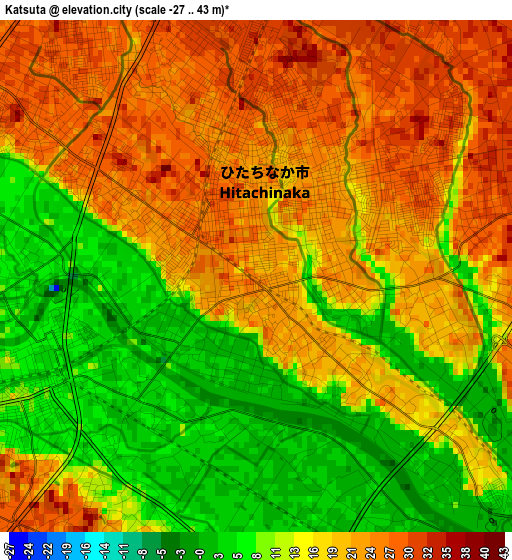
Below is the Elevation map of Katsuta, which displays elevation range with different colors. Scale of the first map is from -27 to 43 m (-89 to 141 ft) with average elevation of 16.7 meters (=55 ft) [note 1]
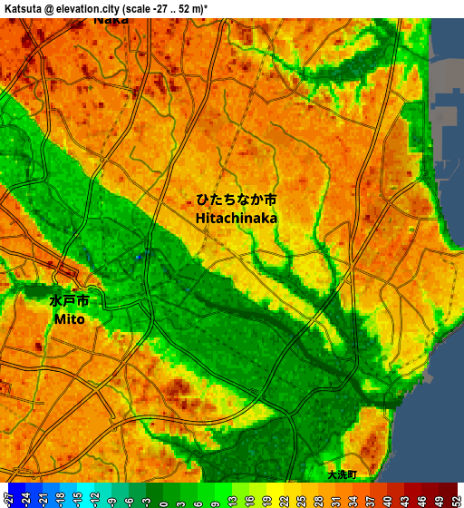
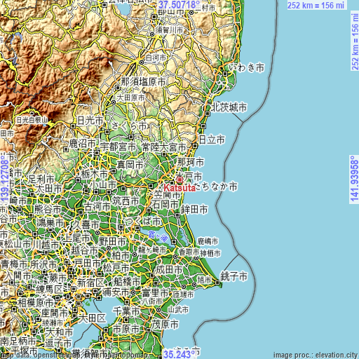
These maps also provides idea of topography and contour of this city, they are displayed at different zoom levels. More info about maps, scale and edge coordinates you can find below images.
| \ | Map #1 | Map #2 | Topo.Map |
| Scale [m] | -27..43 m | -27..52 m | × |
| Scale [ft] | -89..141 ft | -89..171 ft | × |
| Average | 16.7 m = 55 ft | 20.9 m = 69 ft | × |
| Width | 7.87 km = 4.9 mi | 15.74 km = 9.8 mi | 251.8 km = 156.5 mi |
| Height | 7.87 km = 4.9 mi | 15.74 km = 9.8 mi | 251.8 km = 156.5 mi |
| ↑Max Latitude | 36.418701° | 36.454056° | 37.50718° |
| Latitude at center | 36.38333° | 36.38333° | 36.38333° |
| ↓Min Latitude | 36.347943° | 36.31254° | 35.243° |
| ← Min Longitude | 140.489385° | 140.445439° | 139.12708° |
| Longitude center | 140.53333° | 140.53333° | 140.53333° |
| →Max Longitude | 140.577275° | 140.621221° | 141.93958° |
Nearby cities:
Cities around Katsuta sort by population:
• Mito elevation 28 m
8.3 km,  243°
243°
• Hitachi-Naka 31 m
1.5 km,  5°
5°
• Tomobe 45 m
21.2 km,  259°
259°
• Funaishikawa 32 m
9.7 km,  17°
17°
• Okunoya 22 m
15.3 km,  223°
223°
• Kasama 177 m
23.9 km,  270°
270°
• Ōmiya 56 m
21.3 km,  330°
330°
• Ōarai 22 m
8.9 km,  149°
149°
• Hokota 4 m
26 km,  183°
183°
• Hitachiomiya 62 m
23.3 km, 329°
• Omitama 27 m
19.9 km, 223°
• Hitachi-ota 20 m
18.7 km,  358°
358°
Multilingual:
 En español:
Katsuta elevación 21 m.
 En France:
Katsuta élévation 21 m.


Sources and notes:
- [note 1] Map square and city borders are not equal. Map elevation data is calculated only from area inside that square.
- [src 1] Elevation data from geonames database provided with same terms of usage.
- [src 2] The elevation map of Katsuta is generated using elevation data from NASA's 3 arcsec (90m) resolution SRTM data.
- [src 3] Base (background) map © OpenStreetMap contributors tiles are generated by Geofabrik and OpenTopoMap.
Copyright & License:
This Katsuta Elevation Map is licensed under CC BY-SA. You may reuse any part from this page, if you give a proper credit by linking to this URL:
 More info on terms of use page.