Rome elevation
Rome (Latium, Città metropolitana di Roma Capitale), Italy elevation is 52 meters and Rome elevation in feet is 171 ft above sea level [src 1]. Rome is a capital of a political entity (feature code) with elevation that is 270 meters (886 ft) smaller than average city elevation in Italy.
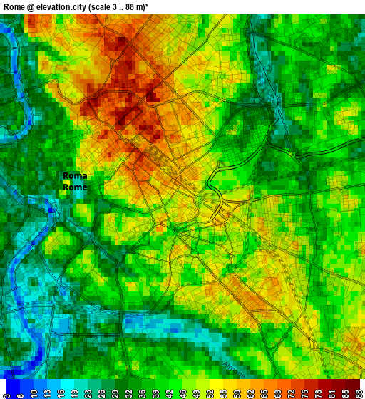
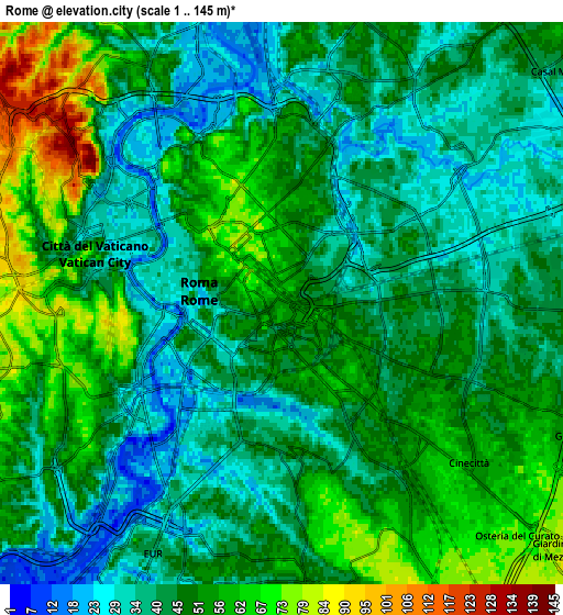
Below is the Elevation map of Rome, which displays elevation range with different colors. Scale of the first map is from 3 to 88 m (10 to 289 ft) with average elevation of 43 meters (=141 ft) [note 1]
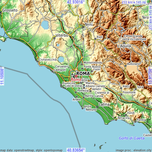
These maps also provides idea of topography and contour of this city, they are displayed at different zoom levels. More info about maps, scale and edge coordinates you can find below images.
| \ | Map #1 | Map #2 | Topo.Map |
| Scale [m] | 3..88 m | 1..145 m | × |
| Scale [ft] | 10..289 ft | 3..476 ft | × |
| Average | 43 m = 141 ft | 47.3 m = 155 ft | × |
| Width | 7.27 km = 4.5 mi | 14.55 km = 9 mi | 232.8 km = 144.7 mi |
| Height | 7.27 km = 4.5 mi | 14.55 km = 9 mi | 232.8 km = 144.7 mi |
| ↑Max Latitude | 41.924635° | 41.957323° | 42.93016° |
| Latitude at center | 41.89193° | 41.89193° | 41.89193° |
| ↓Min Latitude | 41.859208° | 41.82647° | 40.83654° |
| ← Min Longitude | 12.467385° | 12.423439° | 11.10508° |
| Longitude center | 12.51133° | 12.51133° | 12.51133° |
| →Max Longitude | 12.555275° | 12.599221° | 13.91758° |
Nearby cities:
Cities around Rome sort by population:
• Ciampino elevation 127 m
12.6 km,  143°
143°
• Tor Lupara 125 m
14.7 km,  36°
36°
• La Massimina-Casal Lumbroso 47 m
12.9 km,  260°
260°
• Marco Simone 90 m
13.3 km,  57°
57°
• Selcetta 66 m
14.4 km,  191°
191°
• Vitinia 24 m
14.1 km,  217°
217°
• Setteville 77 m
12.9 km, 63°
• Colle Verde 87 m
13 km, 43°
• Ponte Galeria-La Pisana 35 m
15.1 km,  250°
250°
• Colleverde II 90 m
13.6 km,  47°
47°
• Laghetto 94 m
14.6 km, 54°
• Borgo Lotti 109 m
14.7 km,  165°
165°
Multilingual:
 En español:
Roma elevación 52 m.
 En France:
Rome élévation 52 m.


Sources and notes:
- [note 1] Map square and city borders are not equal. Map elevation data is calculated only from area inside that square.
- [src 1] Elevation data from geonames database provided with same terms of usage.
- [src 2] The elevation map of Rome is generated using elevation data from NASA's 3 arcsec (90m) resolution SRTM data.
- [src 3] Base (background) map © OpenStreetMap contributors tiles are generated by Geofabrik and OpenTopoMap.
Copyright & License:
This Rome Elevation Map is licensed under CC BY-SA. You may reuse any part from this page, if you give a proper credit by linking to this URL:
 More info on terms of use page.