Palembang elevation
Palembang (South Sumatra), Indonesia elevation is 5 meters and Palembang elevation in feet is 16 ft above sea level [src 1]. Palembang is a seat of a first-order administrative division (feature code) with elevation that is 186 meters (610 ft) smaller than average city elevation in Indonesia.
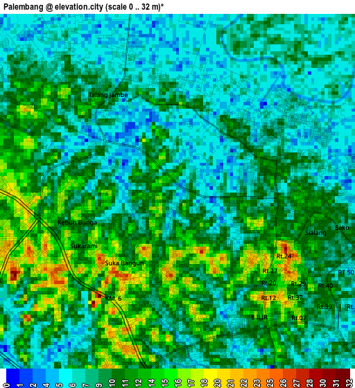
Below is the Elevation map of Palembang, which displays elevation range with different colors. Scale of the first map is from 0 to 32 m (0 to 105 ft) with average elevation of 9.5 meters (=31 ft) [note 1]
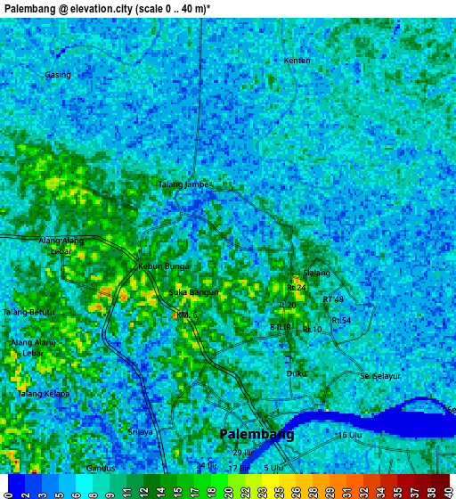
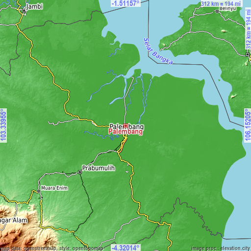
These maps also provides idea of topography and contour of this city, they are displayed at different zoom levels. More info about maps, scale and edge coordinates you can find below images.
| \ | Map #1 | Map #2 | Topo.Map |
| Scale [m] | 0..32 m | 0..40 m | × |
| Scale [ft] | 0..105 ft | 0..131 ft | × |
| Average | 9.5 m = 31 ft | 8.3 m = 27 ft | × |
| Width | 9.76 km = 6.1 mi | 19.52 km = 12.1 mi | 312.3 km = 194.1 mi |
| Height | 9.76 km = 6.1 mi | 19.52 km = 12.1 mi | 312.3 km = 194.1 mi |
| ↑Max Latitude | -2.872841° | -2.82895° | -1.51157° |
| Latitude at center | -2.91673° | -2.91673° | -2.91673° |
| ↓Min Latitude | -2.960618° | -3.004503° | -4.32014° |
| ← Min Longitude | 104.701855° | 104.657909° | 103.33955° |
| Longitude center | 104.7458° | 104.7458° | 104.7458° |
| →Max Longitude | 104.789745° | 104.833691° | 106.15205° |
Nearby cities:
Cities around Palembang sort by population:
• Tanjung Lubuk elevation 19 m
67.8 km,  178°
178°
• Pedamaran 19 m
64.4 km,  170°
170°
• Sungsang 6 m
64 km,  15°
15°
• Sungairotan 13 m
55.9 km,  248°
248°
• Kayu Agung 17 m
53.7 km, 169°
• Tanjung Lubuk 18 m
50.4 km, 167°
• Glumbang 25 m
49.6 km,  223°
223°
• Tanjungraja 20 m
46.9 km, 176°
• Pangkalan Balai 19 m
39.2 km,  275°
275°
• Indralaya 8 m
38.1 km,  191°
191°
• Sungaigerong 0 m
13.5 km,  122°
122°
• Talangbetutu 10 m
7 km,  304°
304°
Multilingual:
 En español:
Palembang elevación 5 m.
 En France:
Palembang élévation 5 m.


Sources and notes:
- [note 1] Map square and city borders are not equal. Map elevation data is calculated only from area inside that square.
- [src 1] Elevation data from geonames database provided with same terms of usage.
- [src 2] The elevation map of Palembang is generated using elevation data from NASA's 3 arcsec (90m) resolution SRTM data.
- [src 3] Base (background) map © OpenStreetMap contributors tiles are generated by Geofabrik and OpenTopoMap.
Copyright & License:
This Palembang Elevation Map is licensed under CC BY-SA. You may reuse any part from this page, if you give a proper credit by linking to this URL:
 More info on terms of use page.