Zaragoza elevation
Zaragoza (Aragon, Provincia de Zaragoza), Spain elevation is 214 meters and Zaragoza elevation in feet is 702 ft above sea level [src 1]. Zaragoza is a seat of a first-order administrative division (feature code) with elevation that is 389 meters (1276 ft) smaller than average city elevation in Spain.
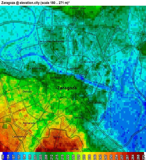
Below is the Elevation map of Zaragoza, which displays elevation range with different colors. Scale of the first map is from 180 to 271 m (591 to 889 ft) with average elevation of 208.3 meters (=683 ft) [note 1]
These maps also provides idea of topography and contour of this city, they are displayed at different zoom levels. More info about maps, scale and edge coordinates you can find below images.
| \ | Map #1 | Map #2 | Topo.Map |
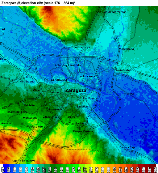
| Scale [m] | 180..271 m | 176..364 m | × |
| Scale [ft] | 591..889 ft | 577..1194 ft | × |
| Average | 208.3 m = 683 ft | 227 m = 745 ft | × |
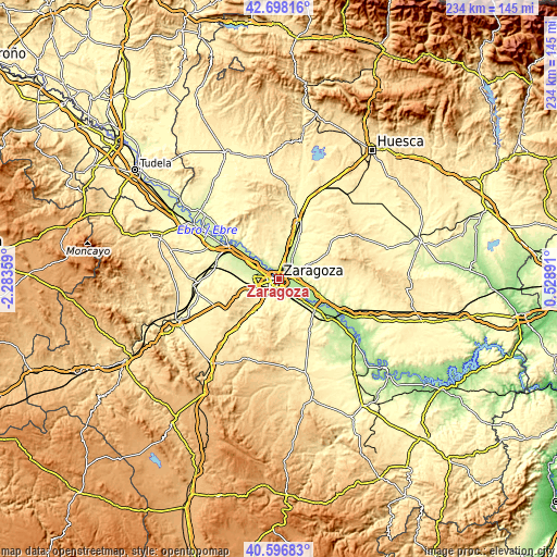
| Width | 7.3 km = 4.5 mi | 14.6 km = 9.1 mi | 233.6 km = 145.2 mi |
| Height | 7.3 km = 4.5 mi | 14.6 km = 9.1 mi | 233.6 km = 145.2 mi |
| ↑Max Latitude | 41.688885° | 41.721694° | 42.69816° |
| Latitude at center | 41.65606° | 41.65606° | 41.65606° |
| ↓Min Latitude | 41.623218° | 41.590359° | 40.59683° |
| ← Min Longitude | -0.921285° | -0.965231° | -2.28359° |
| Longitude center | -0.87734° | -0.87734° | -0.87734° |
| →Max Longitude | -0.833395° | -0.789449° | 0.52891° |
Nearby cities:
Cities around Zaragoza sort by population:
• Delicias elevation 228 m
2.6 km,  253°
253°
• Oliver-Valdefierro 240 m
4.8 km, 254°
• Almozara 205 m
2.1 km,  285°
285°
• Montecanal 259 m
5.9 km,  240°
240°
• Utebo 213 m
11.7 km,  299°
299°
• Villanueva de Gállego 252 m
13.3 km,  19°
19°
• Puebla de Alfindén 201 m
10.8 km,  104°
104°
• Cuarte de Huerva 262 m
8.2 km,  213°
213°
• Villamayor de Gállego 240 m
9.3 km,  69°
69°
• Cadrete 304 m
13.1 km, 211°
• El Burgo de Ebro 186 m
14.7 km,  129°
129°
• Alfajarín 191 m
15.2 km,  107°
107°
Multilingual:
 En español:
Zaragoza elevación 214 m.
 En France:
Saragosse élévation 214 m.
 Auf Deutsch:
Saragossa höhe über dem Meeresspiegel ist 214 m.

Sources and notes:
- [note 1] Map square and city borders are not equal. Map elevation data is calculated only from area inside that square.
- [src 1] Elevation data from geonames database provided with same terms of usage.
- [src 2] The elevation map of Zaragoza is generated using elevation data from NASA's 3 arcsec (90m) resolution SRTM data.
- [src 3] Base (background) map © OpenStreetMap contributors tiles are generated by Geofabrik and OpenTopoMap.
Copyright & License:
This Zaragoza Elevation Map is licensed under CC BY-SA. You may reuse any part from this page, if you give a proper credit by linking to this URL:
 More info on terms of use page.