Murcia elevation
Murcia, Spain elevation is 53 meters and Murcia elevation in feet is 174 ft above sea level [src 1]. Murcia is a seat of a first-order administrative division (feature code) with elevation that is 550 meters (1804 ft) smaller than average city elevation in Spain.
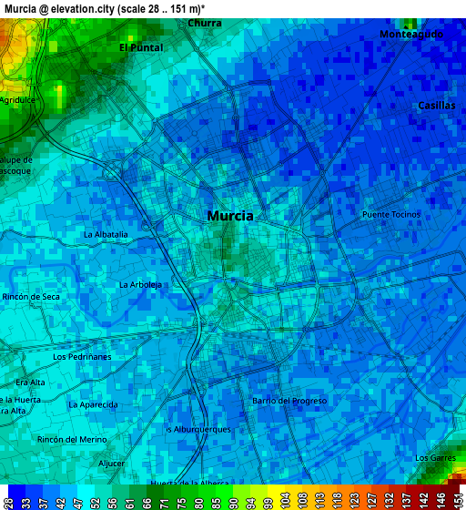
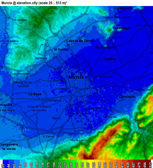
Below is the Elevation map of Murcia, which displays elevation range with different colors. Scale of the first map is from 28 to 151 m (92 to 495 ft) with average elevation of 46.5 meters (=153 ft) [note 1]
These maps also provides idea of topography and contour of this city, they are displayed at different zoom levels. More info about maps, scale and edge coordinates you can find below images.
| \ | Map #1 | Map #2 | Topo.Map |
| Scale [m] | 28..151 m | 25..513 m | × |
| Scale [ft] | 92..495 ft | 82..1683 ft | × |
| Average | 46.5 m = 153 ft | 93 m = 305 ft | × |
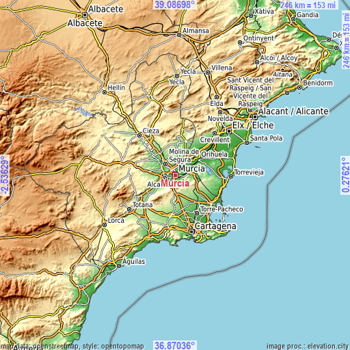
| Width | 7.7 km = 4.8 mi | 15.4 km = 9.6 mi | 246.5 km = 153.2 mi |
| Height | 7.7 km = 4.8 mi | 15.4 km = 9.6 mi | 246.5 km = 153.2 mi |
| ↑Max Latitude | 38.021667° | 38.056278° | 39.08698° |
| Latitude at center | 37.98704° | 37.98704° | 37.98704° |
| ↓Min Latitude | 37.952396° | 37.917736° | 36.87036° |
| ← Min Longitude | -1.173985° | -1.217931° | -2.53629° |
| Longitude center | -1.13004° | -1.13004° | -1.13004° |
| →Max Longitude | -1.086095° | -1.042149° | 0.27621° |
Nearby cities:
Cities around Murcia sort by population:
• Molina de Segura elevation 108 m
10.1 km,  317°
317°
• Alcantarilla 76 m
7.9 km,  255°
255°
• Las Torres de Cotillas 87 m
10.8 km,  295°
295°
• Santomera 38 m
10.9 km,  40°
40°
• Beniel 32 m
13 km,  59°
59°
• Ceuti 95 m
16.3 km,  308°
308°
• Sangonera la Verde 85 m
9.4 km,  226°
226°
• Alguazas 100 m
12.9 km, 305°
• Esparragal 44 m
6.6 km, 38°
• Lorquí 114 m
15 km, 315°
• Santa Cruz 30 m
7.4 km, 58°
• Cobatillas 56 m
8.9 km,  31°
31°
Multilingual:
 En español:
Murcia elevación 53 m.
 En France:
Murcie élévation 53 m.


Sources and notes:
- [note 1] Map square and city borders are not equal. Map elevation data is calculated only from area inside that square.
- [src 1] Elevation data from geonames database provided with same terms of usage.
- [src 2] The elevation map of Murcia is generated using elevation data from NASA's 3 arcsec (90m) resolution SRTM data.
- [src 3] Base (background) map © OpenStreetMap contributors tiles are generated by Geofabrik and OpenTopoMap.
Copyright & License:
This Murcia Elevation Map is licensed under CC BY-SA. You may reuse any part from this page, if you give a proper credit by linking to this URL:
 More info on terms of use page.