Mönchengladbach elevation
Mönchengladbach (North Rhine-Westphalia, Düsseldorf District), Germany elevation is 57 meters and Mönchengladbach elevation in feet is 187 ft above sea level [src 1]. Mönchengladbach is a seat of a third-order administrative division (feature code) with elevation that is 201 meters (659 ft) smaller than average city elevation in Germany.
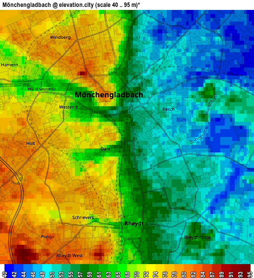
Below is the Elevation map of Mönchengladbach, which displays elevation range with different colors. Scale of the first map is from 40 to 95 m (131 to 312 ft) with average elevation of 62.6 meters (=205 ft) [note 1]
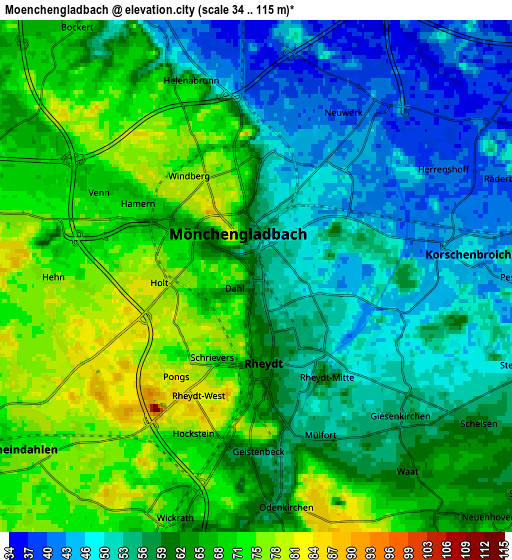
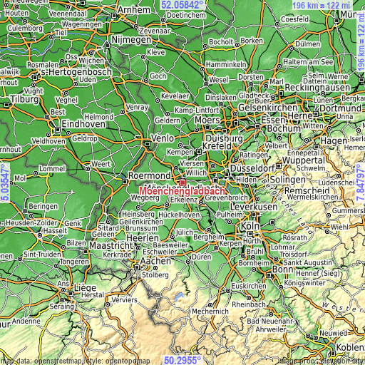
These maps also provides idea of topography and contour of this city, they are displayed at different zoom levels. More info about maps, scale and edge coordinates you can find below images.
| \ | Map #1 | Map #2 | Topo.Map |
| Scale [m] | 40..95 m | 34..115 m | × |
| Scale [ft] | 131..312 ft | 112..377 ft | × |
| Average | 62.6 m = 205 ft | 61 m = 200 ft | × |
| Width | 6.13 km = 3.8 mi | 12.25 km = 7.6 mi | 196 km = 121.8 mi |
| Height | 6.13 km = 3.8 mi | 12.25 km = 7.6 mi | 196 km = 121.8 mi |
| ↑Max Latitude | 51.212927° | 51.240447° | 52.05842° |
| Latitude at center | 51.18539° | 51.18539° | 51.18539° |
| ↓Min Latitude | 51.157837° | 51.130267° | 50.2955° |
| ← Min Longitude | 6.397775° | 6.353829° | 5.03547° |
| Longitude center | 6.44172° | 6.44172° | 6.44172° |
| →Max Longitude | 6.485665° | 6.529611° | 7.84797° |
Nearby cities:
Cities around Mönchengladbach sort by population:
• Viersen elevation 44 m
8.3 km,  336°
336°
• Grevenbroich 52 m
14.4 km,  136°
136°
• Willich 43 m
11.4 km,  40°
40°
• Neubrück 51 m
14.9 km,  112°
112°
• Erkelenz 99 m
14.7 km,  216°
216°
• Kaarst 42 m
13.3 km,  68°
68°
• Korschenbroich 48 m
5 km,  82°
82°
• Tönisvorst 42 m
15.5 km,  13°
13°
• Wegberg 67 m
12 km,  246°
246°
• Jüchen 75 m
10.3 km,  156°
156°
• Schwalmtal 62 m
12.7 km,  285°
285°
• Niederkrüchten 54 m
15.8 km,  275°
275°
Multilingual:
 En español:
Mönchengladbach elevación 57 m.
 En France:
Mönchengladbach élévation 57 m.
 Auf Deutsch:
Mönchengladbach höhe über dem Meeresspiegel ist 57 m.

Sources and notes:
- [note 1] Map square and city borders are not equal. Map elevation data is calculated only from area inside that square.
- [src 1] Elevation data from geonames database provided with same terms of usage.
- [src 2] The elevation map of Mönchengladbach is generated using elevation data from NASA's 3 arcsec (90m) resolution SRTM data.
- [src 3] Base (background) map © OpenStreetMap contributors tiles are generated by Geofabrik and OpenTopoMap.
Copyright & License:
This Mönchengladbach Elevation Map is licensed under CC BY-SA. You may reuse any part from this page, if you give a proper credit by linking to this URL:
 More info on terms of use page.