Tonghua elevation
Tonghua (Jilin, Tonghua Shi), China elevation is 375 meters and Tonghua elevation in feet is 1230 ft above sea level [src 1]. Tonghua is a seat of a second-order administrative division (feature code) with elevation that is 183 meters (600 ft) smaller than average city elevation in China.
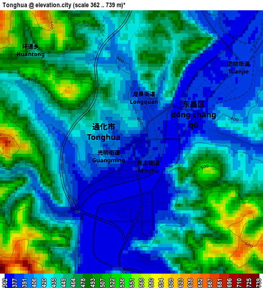
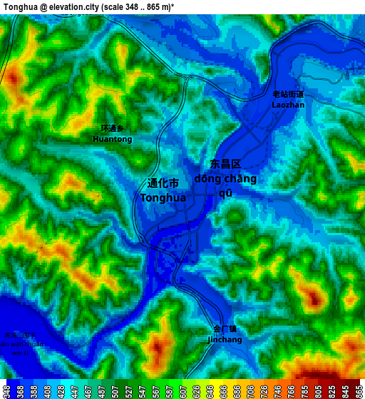
Below is the Elevation map of Tonghua, which displays elevation range with different colors. Scale of the first map is from 362 to 739 m (1188 to 2425 ft) with average elevation of 444.5 meters (=1458 ft) [note 1]
These maps also provides idea of topography and contour of this city, they are displayed at different zoom levels. More info about maps, scale and edge coordinates you can find below images.
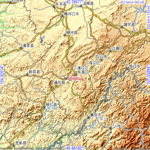
| \ | Map #1 | Map #2 | Topo.Map |
| Scale [m] | 362..739 m | 348..865 m | × |
| Scale [ft] | 1188..2425 ft | 1142..2838 ft | × |
| Average | 444.5 m = 1458 ft | 485.5 m = 1593 ft | × |
| Width | 7.29 km = 4.5 mi | 14.59 km = 9.1 mi | 233.4 km = 145 mi |
| Height | 7.29 km = 4.5 mi | 14.59 km = 9.1 mi | 233.4 km = 145 mi |
| ↑Max Latitude | 41.752513° | 41.785289° | 42.76077° |
| Latitude at center | 41.71972° | 41.71972° | 41.71972° |
| ↓Min Latitude | 41.68691° | 41.654084° | 40.66152° |
| ← Min Longitude | 125.882445° | 125.838499° | 124.52014° |
| Longitude center | 125.92639° | 125.92639° | 125.92639° |
| →Max Longitude | 125.970335° | 126.014281° | 127.33264° |
Nearby cities:
Cities around Tonghua sort by population:
• Baishan elevation 471 m
47.6 km,  59°
59°
• Meihekou 329 m
92.1 km,  347°
347°
• Linjiang 339 m
82 km,  83°
83°
• Liuhe 399 m
60.4 km,  343°
343°
• Sanchazi 558 m
68.8 km,  54°
54°
• Huanren 269 m
68.8 km,  222°
222°
• Hepingjie 730 m
90.2 km,  65°
65°
• Erdaojiang 407 m
10.8 km, 54°
• Jingyu 549 m
102.4 km,  44°
44°
• Ji’an 182 m
69.5 km,  162°
162°
• Sunjia Buzi 587 m
63.8 km, 58°
• Kuaidamao 517 m
16.9 km,  244°
244°
Multilingual:
 En español:
Tonghua elevación 375 m.
 En France:
Tonghua élévation 375 m.


Sources and notes:
- [note 1] Map square and city borders are not equal. Map elevation data is calculated only from area inside that square.
- [src 1] Elevation data from geonames database provided with same terms of usage.
- [src 2] The elevation map of Tonghua is generated using elevation data from NASA's 3 arcsec (90m) resolution SRTM data.
- [src 3] Base (background) map © OpenStreetMap contributors tiles are generated by Geofabrik and OpenTopoMap.
Copyright & License:
This Tonghua Elevation Map is licensed under CC BY-SA. You may reuse any part from this page, if you give a proper credit by linking to this URL:
 More info on terms of use page.