Shijiazhuang elevation
Shijiazhuang (Hebei), China elevation is 77 meters and Shijiazhuang elevation in feet is 253 ft above sea level [src 1]. Shijiazhuang is a seat of a first-order administrative division (feature code) with elevation that is 481 meters (1578 ft) smaller than average city elevation in China.
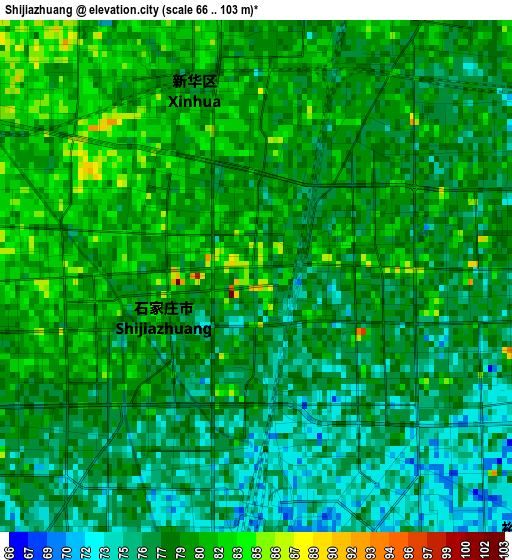
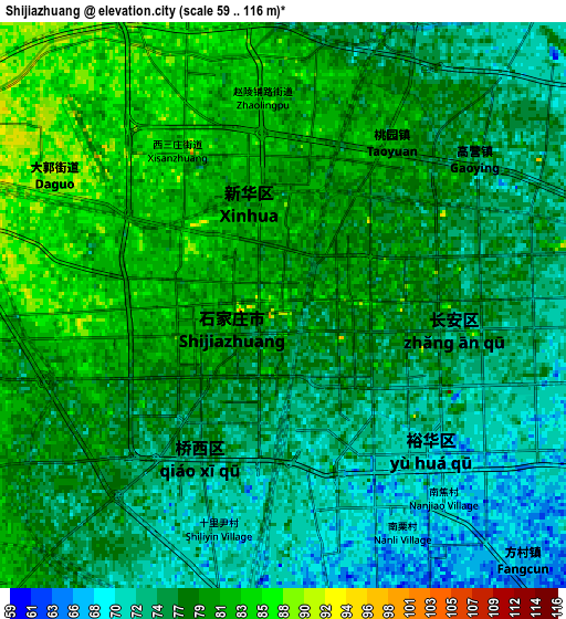
Below is the Elevation map of Shijiazhuang, which displays elevation range with different colors. Scale of the first map is from 66 to 103 m (217 to 338 ft) with average elevation of 78.3 meters (=257 ft) [note 1]
These maps also provides idea of topography and contour of this city, they are displayed at different zoom levels. More info about maps, scale and edge coordinates you can find below images.
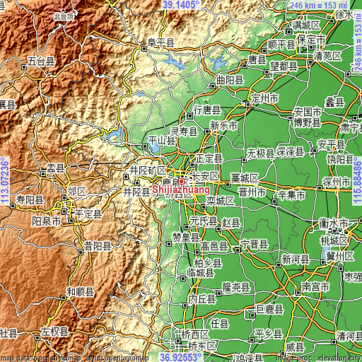
| \ | Map #1 | Map #2 | Topo.Map |
| Scale [m] | 66..103 m | 59..116 m | × |
| Scale [ft] | 217..338 ft | 194..381 ft | × |
| Average | 78.3 m = 257 ft | 77.2 m = 253 ft | × |
| Width | 7.7 km = 4.8 mi | 15.39 km = 9.6 mi | 246.3 km = 153 mi |
| Height | 7.7 km = 4.8 mi | 15.39 km = 9.6 mi | 246.3 km = 153 mi |
| ↑Max Latitude | 38.075992° | 38.110577° | 39.1405° |
| Latitude at center | 38.04139° | 38.04139° | 38.04139° |
| ↓Min Latitude | 38.006772° | 37.972138° | 36.92553° |
| ← Min Longitude | 114.434665° | 114.390719° | 113.07236° |
| Longitude center | 114.47861° | 114.47861° | 114.47861° |
| →Max Longitude | 114.522555° | 114.566501° | 115.88486° |
Nearby cities:
Cities around Shijiazhuang sort by population:
• Xingtai elevation 76 m
108.8 km,  179°
179°
• Luancheng 55 m
23.6 km,  139°
139°
• Yangquan 722 m
82.8 km,  255°
255°
• Dingzhou 64 m
69.2 km,  40°
40°
• Xinji 40 m
65.4 km,  103°
103°
• Tianchang 281 m
40.8 km, 263°
• Xiushui 946 m
95.7 km,  274°
274°
• Leping 914 m
85.8 km,  236°
236°
• Guanshan 771 m
81.6 km,  251°
251°
• Yinying 853 m
81.5 km, 261°
• Yijing 672 m
80.2 km, 253°
• Huolu 139 m
16.6 km,  285°
285°
Multilingual:
 En español:
Shijiazhuang elevación 77 m.
 En France:
Shijiazhuang élévation 77 m.
 Auf Deutsch:
Shijiazhuang höhe über dem Meeresspiegel ist 77 m.

Sources and notes:
- [note 1] Map square and city borders are not equal. Map elevation data is calculated only from area inside that square.
- [src 1] Elevation data from geonames database provided with same terms of usage.
- [src 2] The elevation map of Shijiazhuang is generated using elevation data from NASA's 3 arcsec (90m) resolution SRTM data.
- [src 3] Base (background) map © OpenStreetMap contributors tiles are generated by Geofabrik and OpenTopoMap.
Copyright & License:
This Shijiazhuang Elevation Map is licensed under CC BY-SA. You may reuse any part from this page, if you give a proper credit by linking to this URL:
 More info on terms of use page.