Camaçari elevation
Camaçari (Bahia), Brazil elevation is 29 meters and Camaçari elevation in feet is 95 ft above sea level [src 1]. Camaçari is a populated place (feature code) with elevation that is 353 meters (1158 ft) smaller than average city elevation in Brazil.
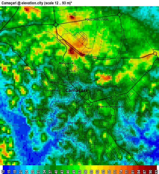
Below is the Elevation map of Camaçari, which displays elevation range with different colors. Scale of the first map is from 12 to 93 m (39 to 305 ft) with average elevation of 39.9 meters (=131 ft) [note 1]
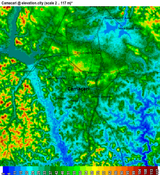
These maps also provides idea of topography and contour of this city, they are displayed at different zoom levels. More info about maps, scale and edge coordinates you can find below images.
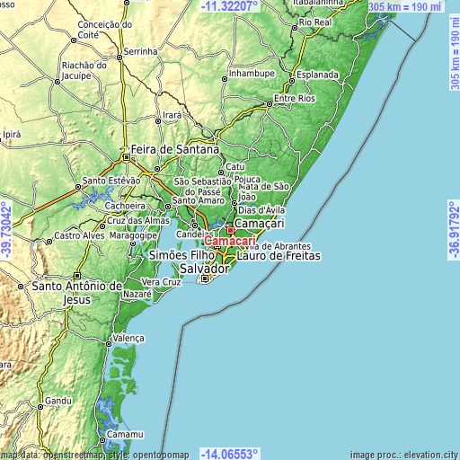
| \ | Map #1 | Map #2 | Topo.Map |
| Scale [m] | 12..93 m | 2..117 m | × |
| Scale [ft] | 39..305 ft | 7..384 ft | × |
| Average | 39.9 m = 131 ft | 39.4 m = 129 ft | × |
| Width | 9.53 km = 5.9 mi | 19.07 km = 11.8 mi | 305 km = 189.5 mi |
| Height | 9.53 km = 5.9 mi | 19.07 km = 11.8 mi | 305.1 km = 189.6 mi |
| ↑Max Latitude | -12.654626° | -12.611744° | -11.32207° |
| Latitude at center | -12.6975° | -12.6975° | -12.6975° |
| ↓Min Latitude | -12.740367° | -12.783227° | -14.06553° |
| ← Min Longitude | -38.368115° | -38.412061° | -39.73042° |
| Longitude center | -38.32417° | -38.32417° | -38.32417° |
| →Max Longitude | -38.280225° | -38.236279° | -36.91792° |
Nearby cities:
Cities around Camaçari sort by population:
• Salvador elevation 10 m
36.5 km,  213°
213°
• Lauro de Freitas 10 m
21.9 km,  180°
180°
• Alagoinhas 158 m
63.3 km,  350°
350°
• Simões Filho 33 m
13 km,  221°
221°
• Santo Amaro 11 m
45.3 km,  291°
291°
• Catu 79 m
38.8 km, 351°
• São Sebastião do Passé 51 m
27.7 km,  317°
317°
• Mata de São João 35 m
18.8 km,  8°
8°
• São Francisco do Conde 21 m
39.4 km,  281°
281°
• Itaparica 20 m
43.9 km,  241°
241°
• Saubara 20 m
48.4 km,  264°
264°
• Madre de Deus 2 m
32.5 km, 261°
Multilingual:
 En español:
Camaçari elevación 29 m.
 En France:
Camaçari élévation 29 m.


Sources and notes:
- [note 1] Map square and city borders are not equal. Map elevation data is calculated only from area inside that square.
- [src 1] Elevation data from geonames database provided with same terms of usage.
- [src 2] The elevation map of Camaçari is generated using elevation data from NASA's 3 arcsec (90m) resolution SRTM data.
- [src 3] Base (background) map © OpenStreetMap contributors tiles are generated by Geofabrik and OpenTopoMap.
Copyright & License:
This Camaçari Elevation Map is licensed under CC BY-SA. You may reuse any part from this page, if you give a proper credit by linking to this URL:
 More info on terms of use page.