Petrolina elevation
Petrolina (Pernambuco), Brazil elevation is 383 meters and Petrolina elevation in feet is 1257 ft above sea level [src 1]. Petrolina is a populated place (feature code) with elevation that is 1 meters (3 ft) bigger than average city elevation in Brazil.
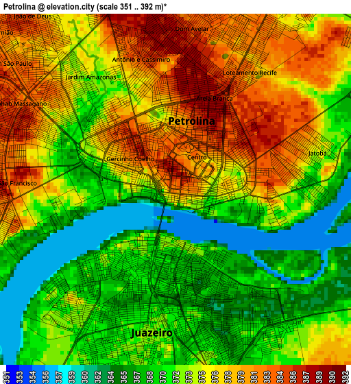
Below is the Elevation map of Petrolina, which displays elevation range with different colors. Scale of the first map is from 351 to 392 m (1152 to 1286 ft) with average elevation of 373.7 meters (=1226 ft) [note 1]
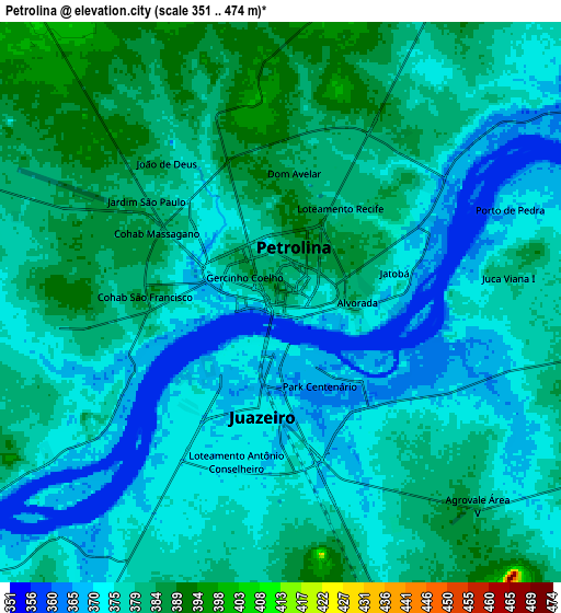
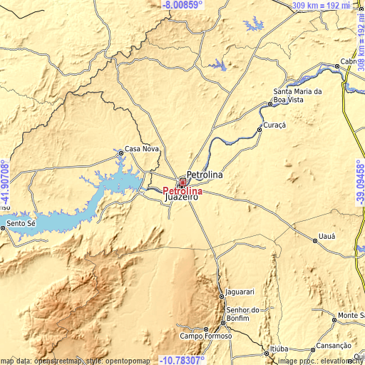
These maps also provides idea of topography and contour of this city, they are displayed at different zoom levels. More info about maps, scale and edge coordinates you can find below images.
| \ | Map #1 | Map #2 | Topo.Map |
| Scale [m] | 351..392 m | 351..474 m | × |
| Scale [ft] | 1152..1286 ft | 1152..1555 ft | × |
| Average | 373.7 m = 1226 ft | 377.2 m = 1238 ft | × |
| Width | 9.64 km = 6 mi | 19.28 km = 12 mi | 308.5 km = 191.7 mi |
| Height | 9.64 km = 6 mi | 19.28 km = 12 mi | 308.5 km = 191.7 mi |
| ↑Max Latitude | -9.355252° | -9.311888° | -8.00859° |
| Latitude at center | -9.39861° | -9.39861° | -9.39861° |
| ↓Min Latitude | -9.441963° | -9.48531° | -10.78307° |
| ← Min Longitude | -40.544775° | -40.588721° | -41.90708° |
| Longitude center | -40.50083° | -40.50083° | -40.50083° |
| →Max Longitude | -40.456885° | -40.412939° | -39.09458° |
Nearby cities:
Cities around Petrolina sort by population:
• Senhor do Bonfim elevation 544 m
123 km,  163°
163°
• Ouricuri 451 m
174.8 km,  15°
15°
• Campo Formoso 580 m
124.9 km,  170°
170°
• Jaguarari 660 m
101.8 km, 160°
• Pindobaçu 435 m
150.1 km, 174°
• Cabrobó 327 m
163.6 km,  53°
53°
• Santa Maria da Boa Vista 351 m
99.1 km, 48°
• Curaçá 359 m
79.2 km,  55°
55°
• Uauá 440 m
122.1 km,  113°
113°
• Monte Santo 483 m
172.4 km,  132°
132°
• Ponto Novo 370 m
167.7 km, 166°
• Laje 576 m
101.7 km,  210°
210°
Multilingual:
 En español:
Petrolina elevación 383 m.
 En France:
Petrolina élévation 383 m.
 Auf Deutsch:
Petrolina höhe über dem Meeresspiegel ist 383 m.

Sources and notes:
- [note 1] Map square and city borders are not equal. Map elevation data is calculated only from area inside that square.
- [src 1] Elevation data from geonames database provided with same terms of usage.
- [src 2] The elevation map of Petrolina is generated using elevation data from NASA's 3 arcsec (90m) resolution SRTM data.
- [src 3] Base (background) map © OpenStreetMap contributors tiles are generated by Geofabrik and OpenTopoMap.
Copyright & License:
This Petrolina Elevation Map is licensed under CC BY-SA. You may reuse any part from this page, if you give a proper credit by linking to this URL:
 More info on terms of use page.