Recife elevation
Recife (Pernambuco), Brazil elevation is 8 meters and Recife elevation in feet is 26 ft above sea level [src 1]. Recife is a seat of a first-order administrative division (feature code) with elevation that is 374 meters (1227 ft) smaller than average city elevation in Brazil.
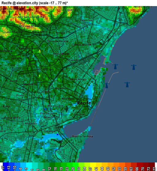
Below is the Elevation map of Recife, which displays elevation range with different colors. Scale of the first map is from -17 to 77 m (-56 to 253 ft) with average elevation of 11.4 meters (=37 ft) [note 1]
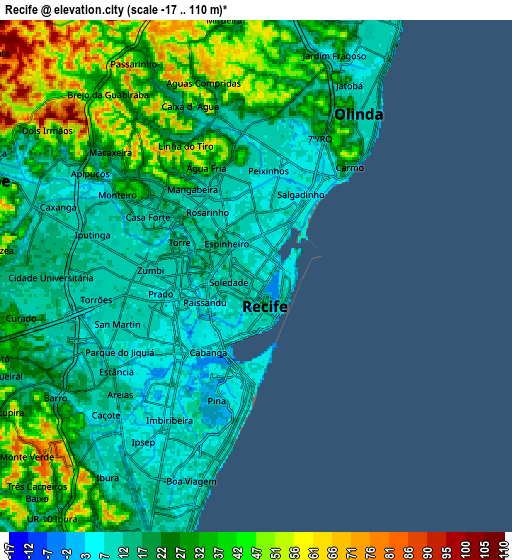
These maps also provides idea of topography and contour of this city, they are displayed at different zoom levels. More info about maps, scale and edge coordinates you can find below images.
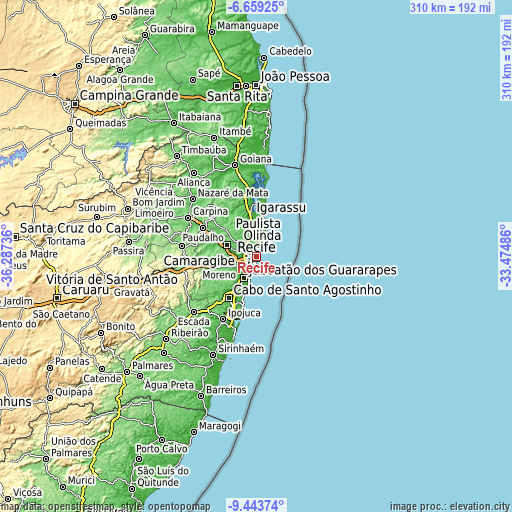
| \ | Map #1 | Map #2 | Topo.Map |
| Scale [m] | -17..77 m | -17..110 m | × |
| Scale [ft] | -56..253 ft | -56..361 ft | × |
| Average | 11.4 m = 37 ft | 24.6 m = 81 ft | × |
| Width | 9.68 km = 6 mi | 19.35 km = 12 mi | 309.6 km = 192.4 mi |
| Height | 9.68 km = 6 mi | 19.35 km = 12 mi | 309.6 km = 192.4 mi |
| ↑Max Latitude | -8.010376° | -7.966857° | -6.65925° |
| Latitude at center | -8.05389° | -8.05389° | -8.05389° |
| ↓Min Latitude | -8.0974° | -8.140904° | -9.44374° |
| ← Min Longitude | -34.925055° | -34.969001° | -36.28736° |
| Longitude center | -34.88111° | -34.88111° | -34.88111° |
| →Max Longitude | -34.837165° | -34.793219° | -33.47486° |
Nearby cities:
Cities around Recife sort by population:
• Jaboatão elevation 88 m
19.3 km,  223°
223°
• Jaboatão dos Guararapes 48 m
16.1 km,  246°
246°
• Olinda 37 m
5.8 km,  29°
29°
• Paulista 20 m
12.6 km,  4°
4°
• Cabo 16 m
30.5 km,  213°
213°
• São Lourenço da Mata 48 m
16.2 km,  290°
290°
• Igarassu 22 m
24.6 km,  353°
353°
• Abreu e Lima 30 m
16 km, 351°
• Moreno 78 m
24.3 km, 252°
• Itapissuma 13 m
30.9 km,  357°
357°
• Itamaracá 7 m
34.6 km,  10°
10°
• Araçoiaba 166 m
37.3 km,  321°
321°
Multilingual:
 En español:
Recife elevación 8 m.
 En France:
Recife élévation 8 m.


Sources and notes:
- [note 1] Map square and city borders are not equal. Map elevation data is calculated only from area inside that square.
- [src 1] Elevation data from geonames database provided with same terms of usage.
- [src 2] The elevation map of Recife is generated using elevation data from NASA's 3 arcsec (90m) resolution SRTM data.
- [src 3] Base (background) map © OpenStreetMap contributors tiles are generated by Geofabrik and OpenTopoMap.
Copyright & License:
This Recife Elevation Map is licensed under CC BY-SA. You may reuse any part from this page, if you give a proper credit by linking to this URL:
 More info on terms of use page.