Sydney elevation
Sydney (New South Wales), Australia elevation is 1 meters and Sydney elevation in feet is 3 ft above sea level [src 1]. Sydney is a seat of a first-order administrative division (feature code) with elevation that is 112 meters (367 ft) smaller than average city elevation in Australia.
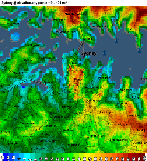
Below is the Elevation map of Sydney, which displays elevation range with different colors. Scale of the first map is from -19 to 101 m (-62 to 331 ft) with average elevation of 33.1 meters (=109 ft) [note 1]
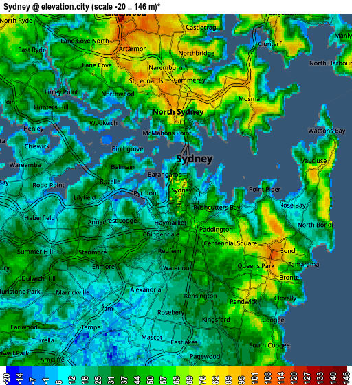
These maps also provides idea of topography and contour of this city, they are displayed at different zoom levels. More info about maps, scale and edge coordinates you can find below images.
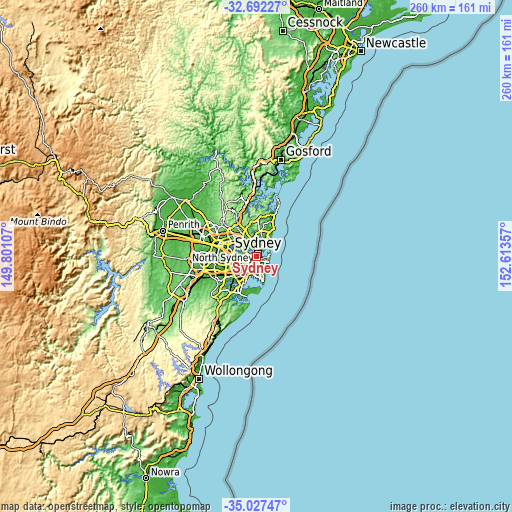
| \ | Map #1 | Map #2 | Topo.Map |
| Scale [m] | -19..101 m | -20..146 m | × |
| Scale [ft] | -62..331 ft | -66..479 ft | × |
| Average | 33.1 m = 109 ft | 36.3 m = 119 ft | × |
| Width | 8.11 km = 5 mi | 16.23 km = 10.1 mi | 259.6 km = 161.3 mi |
| Height | 8.11 km = 5 mi | 16.23 km = 10.1 mi | 259.7 km = 161.4 mi |
| ↑Max Latitude | -33.831353° | -33.794841° | -32.69227° |
| Latitude at center | -33.86785° | -33.86785° | -33.86785° |
| ↓Min Latitude | -33.904331° | -33.940797° | -35.02747° |
| ← Min Longitude | 151.163375° | 151.119429° | 149.80107° |
| Longitude center | 151.20732° | 151.20732° | 151.20732° |
| →Max Longitude | 151.251265° | 151.295211° | 152.61357° |
Nearby cities:
Cities around Sydney sort by population:
• Sydney Central Business District elevation 76 m
0.3 km,  6°
6°
• Surry Hills 41 m
1.8 km,  163°
163°
• Pyrmont 20 m
1.2 km,  259°
259°
• Potts Point 17 m
1.7 km,  86°
86°
• Darlinghurst 53 m
1.7 km,  139°
139°
• Haymarket 24 m
1.2 km,  188°
188°
• Ultimo 30 m
1.4 km,  221°
221°
• Elizabeth Bay 46 m
1.9 km,  103°
103°
• Woolloomooloo 6 m
1.2 km, 104°
• The Rocks 19 m
1 km,  4°
4°
• Balmain East 34 m
1.8 km,  311°
311°
• Millers Point 31 m
1 km,  341°
341°
Multilingual:
 En español:
Sídney elevación 1 m.
 En France:
Sydney élévation 1 m.


Sources and notes:
- [note 1] Map square and city borders are not equal. Map elevation data is calculated only from area inside that square.
- [src 1] Elevation data from geonames database provided with same terms of usage.
- [src 2] The elevation map of Sydney is generated using elevation data from NASA's 3 arcsec (90m) resolution SRTM data.
- [src 3] Base (background) map © OpenStreetMap contributors tiles are generated by Geofabrik and OpenTopoMap.
Copyright & License:
This Sydney Elevation Map is licensed under CC BY-SA. You may reuse any part from this page, if you give a proper credit by linking to this URL:
 More info on terms of use page.